METAR & TAF KMIO
Current METAR
Observed 18:55Z
KMIO 271855Z AUTO 19011KT 10SM CLR 37/22 A2987 RMK A01 TSNO
- Wind
- 190° @ 11 kt
- Visibility
- 10 SM
- Temp / Dew
- 37°C / 22°C
- Altimeter
- 29.87 inHg
- Clouds
- CLR
- Density alt
- 3,702 ft
- Ceiling
- Unlimited
- Rules
- VFR
Airport info & contacts
Manager on record, flight service, ARTCC, attendance schedule and pattern altitude — published by the FAA and refreshed every 28 days.
Location
- From city
- 2 NM NW
- VFR sectional
- KANSAS CITY
- ARTCC
- ZKC · KANSAS CITY
- NOTAM facility
- MLC (NOTAM-D)
Airport manager
- Name
- JILL FITZGIBBON
- Phone
- 918-541-2349
- Address
- 2600 REX PLOTT DR, MIAMI OK 74355
Flight service · Hours
- FSS MLC
- MC ALESTER1-800-WX-BRIEF
- Attendance
- MON-FRI · 0800-1630
Frequencies
Tap any row to copy the frequency to your clipboard.
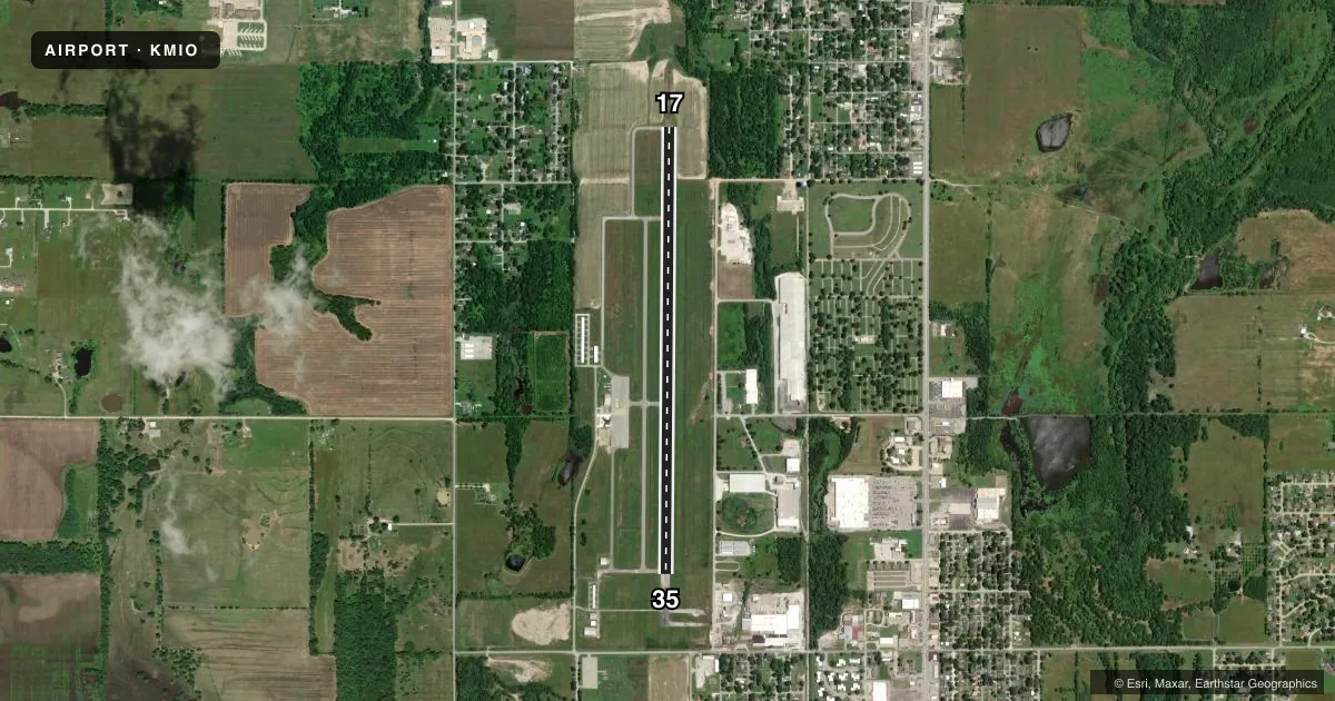
Runways & pattern
Full pagePattern entry · RWY 17
RIGHT TRAFFICRunway end performance
| End | TORA | TODA | ASDA | LDA | VGSI | Approach lights | Obstruction |
|---|---|---|---|---|---|---|---|
| 17 | — | — | — | — | PAPI 4-box left(3°) | ODALS | 38', trees, 735' from thr, 115' R of cntrln, slope 14 |
| 35 | — | — | — | — | PAPI 4-box left(3°) | — | — |
Declared distances in feet. TORA = takeoff run available, TODA = takeoff distance, ASDA = accelerate-stop, LDA = landing distance.
Airport sketch
Runways drawn to scale from FAA survey coordinates, rendered over satellite imagery. Not for navigation.
Approaches & charts
Services on the field
Fuel grades, oxygen, maintenance, ramp storage and lighting — as declared to the FAA by the airport operator.
Fuel & services
- Fuel
- 100LLA+
- Oxygen (bottled)
- Not available
- Oxygen (bulk)
- Not available
- Airframe repair
- Not available
- Power plant repair
- Not available
- Other services
- AGRI,INSTR
Ramp & ground
- Transient storage
- Tie-down
- Hangar
- Landing fee
- No fee published
- Customs
- Not available
- Lighting schedule
- SEE RMK
- Beacon schedule
- SS-SR
- Beacon
- White / Green (civil land)(WG)
- Wind indicator
- Lighted
- Segmented circle
- Yes
Fuel & FBOs
Cheapest 100LL and Jet A on the field and nearby. Always confirm with the FBO before taxi.
Airport notes
Surface conditions, obstructions, local procedures, lighting outages and other notes published with each FAA cycle.
General notes
- FOR CD CTC KANSAS CITY ARTCC AT 913-254-8508.
Lighting notes
- DUSK-DAWN. ACTVT ODALS RWY 17; REIL RWY 35; MIRL RWY 17/35 - CTAF.
Fuel notes
- 100LLFUEL AVBL 24 HRS WITH CC.
Other notes
- ESTAB PRIOR TO 1959.
- 1EXCL CITY HOLIDAYS
- MANAGERALT PHONE # 918-961-0959.
VFR map & nearby airports
VFR sectional. Tap any ICAO chip to open that airport.
Key facts · KMIO
Answer card- ICAO
- KMIO
- Name
- MIAMI RGNL
- Location
- MIAMI, OKLAHOMA
- Elevation
- 806.4 ft MSL
- Traffic pattern altitude
- 1,806.4 ft MSL (1,000 AGL)
- Control tower
- Non-towered (use CTAF)
- Total runways
- 1
- Longest runway
- 17/35 · 5,020 ft
- Published ILS approaches
- 0
- Published frequencies
- 2
- Magnetic variation
- 5°
- Current flight rules
- VFR
- Current wind
- 190° at 11 kt
- Favored runway now
- RWY 17
Miami Rgnl sits in Miami, Oklahoma. Field elevation is 806.4 ft MSL. The airport has one asphalt runway, 17/35, at 5,020 ft. There is no control tower. Use CTAF 122.8 for traffic calls. No ILS approaches are published here.
Pattern altitude is not published. Use the standard 1,000 ft AGL pattern unless local procedures or the current Chart Supplement say otherwise. The airport uses 122.8 for both CTAF and UNICOM. Lighting is available from dusk to dawn. Runway 17 has an omni-directional approach lighting system. Runway 35 has runway end identifier lights. Medium intensity runway lights are installed on both ends.
Miami Airport is on the field. It carries 100LL and Jet A. 100LL is available 24 hours with a credit card. The airport is closed on city holidays. For clearance delivery, contact Kansas City Center. This is a non-towered field with a single runway, so keep your pattern work tight and make your radio calls early. Check the current Chart Supplement for any published noise or curfew restrictions before flying in.