METAR & TAF 1K8
Current METAR
Observed 13:35Z
K1K8 271335Z AUTO 21006KT 10SM CLR 30/22 A2993 RMK AO2
- Wind
- 210° @ 6 kt
- Visibility
- 10 SM
- Temp / Dew
- 30°C / 22°C
- Altimeter
- 29.93 inHg
- Clouds
- CLR
- Density alt
- 2,758 ft
- Ceiling
- Unlimited
- Rules
- VFR
Airport info & contacts
Manager on record, flight service, ARTCC, attendance schedule and pattern altitude — published by the FAA and refreshed every 28 days.
Location
- From city
- 1 NM NE
- VFR sectional
- KANSAS CITY
- ARTCC
- ZKC · KANSAS CITY
- NOTAM facility
- MLC (NOTAM-D)
Airport manager
- Name
- JIM BROWN
- Phone
- 918-782-9178
- Address
- P.O. BOX 928, RT 3 BOX 1557, KETCHUM OK 74349
Flight service · Hours
- FSS MLC
- MC ALESTER1-800-WX-BRIEF
- Attendance
- Unattended
Frequencies
Tap any row to copy the frequency to your clipboard.
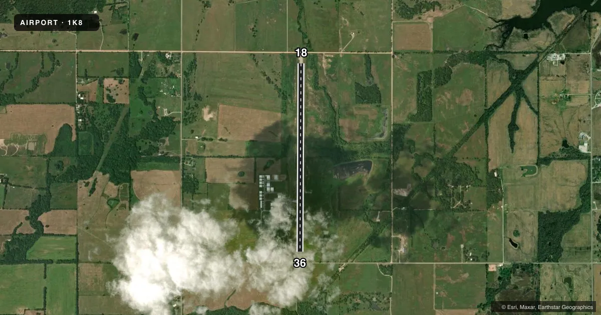
Runways & pattern
Full pagePattern entry · RWY 18
LEFT TRAFFICRunway end performance
| End | TORA | TODA | ASDA | LDA | VGSI | Approach lights | Obstruction |
|---|---|---|---|---|---|---|---|
| 18 | 4,299' | 4,299' | 4,670' | 4,228' | PAPI 4-box left(4°) | — | 16', road, 265' from thr, 0' R of cntrln, slope 20 |
| 36 | 4,287' | 4,287' | 4,670' | 4,238' | PAPI 4-box left(3°) | — | 15', road, 270' from thr, 0' R of cntrln, slope 20 |
Declared distances in feet. TORA = takeoff run available, TODA = takeoff distance, ASDA = accelerate-stop, LDA = landing distance.
Airport sketch
Runways drawn to scale from FAA survey coordinates, rendered over satellite imagery. Not for navigation.
Approaches & charts
Services on the field
Fuel grades, oxygen, maintenance, ramp storage and lighting — as declared to the FAA by the airport operator.
Fuel & services
- Fuel
- 100LLA+
- Airframe repair
- Not available
- Power plant repair
- Not available
- Other services
- INSTR,SALES
Ramp & ground
- Transient storage
- Tie-down
- Hangar
- Lighting schedule
- SEE RMK
- Wind indicator
- Lighted
- Segmented circle
- No
Fuel & FBOs
Cheapest 100LL and Jet A on the field and nearby. Always confirm with the FBO before taxi.
Airport notes
Surface conditions, obstructions, local procedures, lighting outages and other notes published with each FAA cycle.
General notes
- FOR CD CTC KANSAS CITY ARTCC AT 913-254-8508.
- SELF SVC FUEL H24 WITH CREDIT CARD.
Lighting notes
- ACTVT MIRL RWY 18/36 - CTAF. PAPI RWY 18 & 36 ON CONSLY.
Approach & departure obstructions
- 1816 FT TREE 116 FT FM RWY 18 THR 250 FT LEFT OF EXTDD CNTRLN.
- 18ROAD OBS CLNC SLOPE 44:1 TO DTHR; 216 FT HILL 4789 FT FM THR 38:1 OBS CLNC SLOPE TO DTHR.
Other notes
- PROVDD BOTH RWY THLDS LCTD SO AS TO ASSURE A MOC OF 20:1 OVR ALL OBSTNS IN FNA AREAS.
VFR map & nearby airports
VFR sectional. Tap any ICAO chip to open that airport.
Key facts · 1K8
Answer card- ICAO
- 1K8
- Name
- SOUTH GRAND LAKE RGNL
- Location
- KETCHUM, OKLAHOMA
- Elevation
- 782.7 ft MSL
- Traffic pattern altitude
- 1,782.7 ft MSL (1,000 AGL)
- Control tower
- Non-towered (use CTAF)
- Total runways
- 1
- Longest runway
- 18/36 · 4,730 ft
- Published ILS approaches
- 0
- Published frequencies
- 1
- Magnetic variation
- 2°
- Current flight rules
- VFR
- Current wind
- 210° at 6 kt
- Favored runway now
- RWY 18
South Grand Lake Regional Airport sits near Ketchum, Oklahoma. Field elevation is 782.7 ft MSL. The airport has one runway. Runway 18/36 is 4,730 ft long with an asphalt surface. There is no control tower. CTAF is 122.9.
No ILS approaches are published here. Pattern altitude is not published, so use the standard 1,000 ft AGL for light piston operations unless the current Chart Supplement says otherwise. The field has one on-field FBO, South Grand Lake Regional Airport. It carries 100LL and Jet A. Self-serve fuel is available 24 hours a day with a credit card.
A few remarks matter for planning. Runway 18 has a tree close to the threshold. There is also a road obstruction slope to the displaced threshold on 18. A hill sits several thousand feet from the threshold on that end as well. Medium intensity runway lights for 18/36 are activated on the CTAF. The PAPI for both runway directions is on continuously. Clearance delivery is handled through Kansas City ARTCC. For a first-time arrival, pay attention to the obstruction notes on 18 and expect a non-towered pattern with standard CTAF work.