METAR & TAF H71
Current METAR
Observed 15:55Z
KH71 271555Z AUTO 20010KT 10SM CLR 32/22 A2991 RMK AO2 TSNO
- Wind
- 200° @ 10 kt
- Visibility
- 10 SM
- Temp / Dew
- 32°C / 22°C
- Altimeter
- 29.91 inHg
- Clouds
- CLR
- Density alt
- 2,824 ft
- Ceiling
- Unlimited
- Rules
- VFR
Airport info & contacts
Manager on record, flight service, ARTCC, attendance schedule and pattern altitude — published by the FAA and refreshed every 28 days.
Location
- From city
- 6 NM S
- VFR sectional
- KANSAS CITY
- ARTCC
- ZKC · KANSAS CITY
- NOTAM facility
- MLC (NOTAM-D)
Airport manager
- Name
- BRYCE BULLARD
- Phone
- 918-476-6096
- Address
- 5249 WEBB ST, MAIP, PRYOR OK 74361
Flight service · Hours
- FSS MLC
- MC ALESTER1-800-WX-BRIEF
- Attendance
- MON-FRI · 0800-1700
Frequencies
Tap any row to copy the frequency to your clipboard.
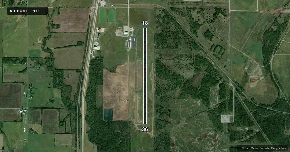
Runways & pattern
Full pagePattern entry · RWY 18
RIGHT TRAFFICRunway end performance
| End | TORA | TODA | ASDA | LDA | VGSI | Approach lights | Obstruction |
|---|---|---|---|---|---|---|---|
| 18 | — | — | — | — | PAPI 4-box left(3°) | — | — |
| 36 | — | — | — | — | PAPI 4-box left(3°) | — | 48', trees, 1720' from thr, 60' R of cntrln, slope 31 |
Declared distances in feet. TORA = takeoff run available, TODA = takeoff distance, ASDA = accelerate-stop, LDA = landing distance.
Airport sketch
Runways drawn to scale from FAA survey coordinates, rendered over satellite imagery. Not for navigation.
Approaches & charts
Services on the field
Fuel grades, oxygen, maintenance, ramp storage and lighting — as declared to the FAA by the airport operator.
Fuel & services
- Fuel
- 100LLA+
- Other services
- AMB,GLD
Ramp & ground
- Transient storage
- Tie-down
- Landing fee
- No fee published
- Customs
- Not available
- Lighting schedule
- SEE RMK
- Beacon schedule
- SS-SR
- Beacon
- White / Green (civil land)(WG)
- Wind indicator
- Lighted
- Segmented circle
- Yes
Fuel & FBOs
Cheapest 100LL and Jet A on the field and nearby. Always confirm with the FBO before taxi.
Airport notes
Surface conditions, obstructions, local procedures, lighting outages and other notes published with each FAA cycle.
General notes
- WKEND GLDR OPS ON & INVOF ARPT.
- FOR CD CTC TULSA APCH AT 918-831-6714.
Lighting notes
- ACTVT REIL RWY 18 & 36; MIRL RWY 18/36 - CTAF.
Fuel notes
- 100LLAVBL H24 WITH CREDIT CARD.
- A+AVBL H24 WITH CREDIT CARD.
Approach & departure obstructions
- 18UNUSBL BYD 9 DEGS RIGHT OF CNTRLN.
VFR map & nearby airports
VFR sectional. Tap any ICAO chip to open that airport.
Key facts · H71
Answer card- ICAO
- H71
- Name
- MID-AMERICA INDUSTRIAL
- Location
- PRYOR, OKLAHOMA
- Elevation
- 622.4 ft MSL
- Traffic pattern altitude
- 1,622.4 ft MSL (1,000 AGL)
- Control tower
- Non-towered (use CTAF)
- Total runways
- 1
- Longest runway
- 18/36 · 5,001 ft
- Published ILS approaches
- 0
- Published frequencies
- 4
- Magnetic variation
- 2°
- Current flight rules
- VFR
- Current wind
- 200° at 10 kt
- Favored runway now
- RWY 18
Mid-America Industrial Airport (H71) sits in Pryor, Oklahoma. Field elevation is 622.4 ft MSL. The airport has one runway. Runway 18/36 is 5,001 ft of asphalt, so it works for light piston traffic and some larger aircraft within performance limits. The airport is non-towered. Pattern altitude is not published, so use the standard 1,000 ft AGL for light piston operations unless the current Chart Supplement says otherwise.
There are no ILS approaches published here. Tulsa Approach handles departure and approach services on 119.1 and 360.825. CTAF and UNICOM are both 122.8. The on-field FBO is MidAmerica Industrial Airport. It carries 100LL and Jet A Prist. Fuel is available 24 hours a day with credit card. Runway end identifier lights are installed on 18 and 36. Medium intensity runway lights are also on 18 and 36. They are controlled by CTAF. Runway 18 is unusable beyond 9 degrees right of the centerline, so plan your approach carefully. Weekend glider operations also occur on and near the airport. If you need a clearance, contact Tulsa Approach at 918-831-6714 before departure.