METAR & TAF KGCM
Current METAR
Observed 13:15Z
KGCM 271315Z AUTO 16004KT 10SM CLR 21/14 A2993 RMK AO2
- Wind
- 160° @ 4 kt
- Visibility
- 10 SM
- Temp / Dew
- 21°C / 14°C
- Altimeter
- 29.93 inHg
- Clouds
- CLR
- Density alt
- 1,617 ft
- Ceiling
- Unlimited
- Rules
- VFR
Airport info & contacts
Manager on record, flight service, ARTCC, attendance schedule and pattern altitude — published by the FAA and refreshed every 28 days.
Location
- From city
- 7 NM E
- VFR sectional
- KANSAS CITY
- ARTCC
- ZKC · KANSAS CITY
- NOTAM facility
- GCM (NOTAM-D)
Airport manager
- Name
- COLBY LINDER
- Phone
- 918-343-0931
- Address
- 19502 E. ROGERS POST ROAD, CLAREMORE OK 74019
Flight service · Hours
- FSS MLC
- MC ALESTER1-800-WX-BRIEF
- Attendance
- 0800-1700
Frequencies
Tap any row to copy the frequency to your clipboard.
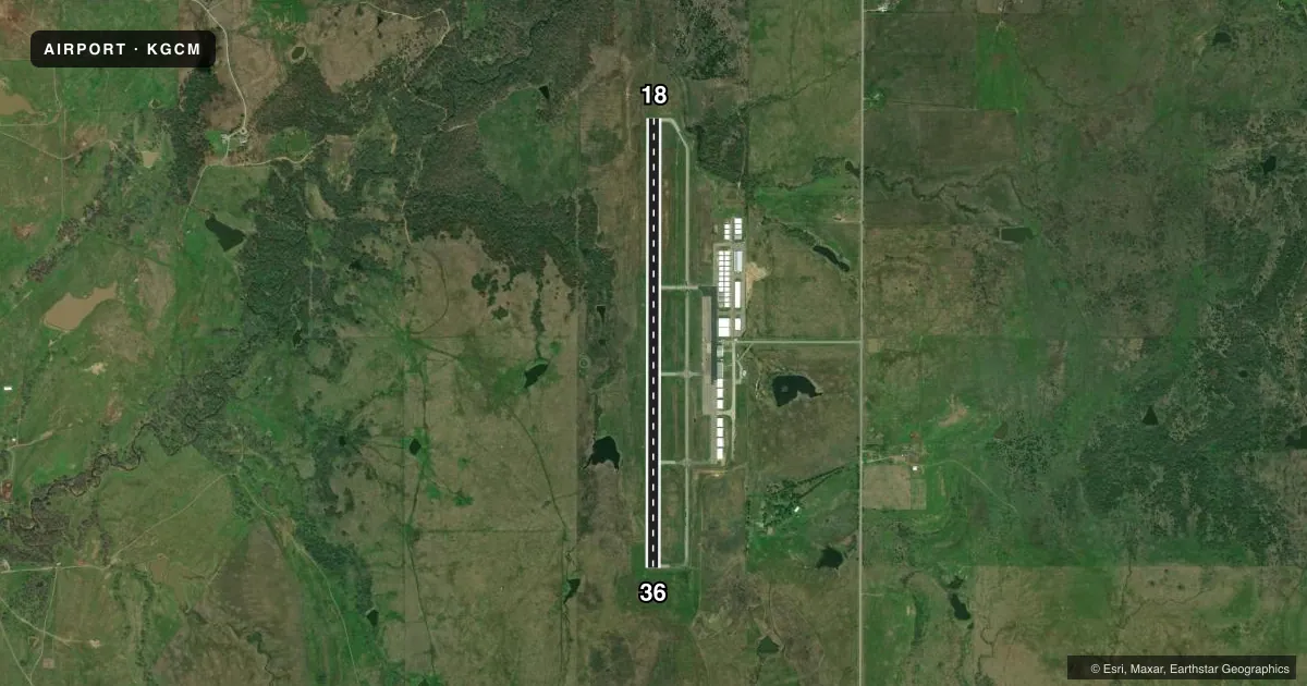
Runways & pattern
Full pagePattern entry · RWY 18
LEFT TRAFFICRunway end performance
| End | TORA | TODA | ASDA | LDA | VGSI | Approach lights | Obstruction |
|---|---|---|---|---|---|---|---|
| 18 | — | — | — | — | PAPI 4-box left(3°) | ODALS | 33', trees, 615' from thr, 120' R of cntrln, slope 12 |
| 36 | — | — | — | — | PAPI 4-box left(3°) | — | 20', trees, 632' from thr, 0' R of cntrln, slope 21 |
Declared distances in feet. TORA = takeoff run available, TODA = takeoff distance, ASDA = accelerate-stop, LDA = landing distance.
Airport sketch
Runways drawn to scale from FAA survey coordinates, rendered over satellite imagery. Not for navigation.
Approaches & charts
Services on the field
Fuel grades, oxygen, maintenance, ramp storage and lighting — as declared to the FAA by the airport operator.
Fuel & services
- Fuel
- 100LLA
- Oxygen (bottled)
- Not available
- Oxygen (bulk)
- Not available
- Airframe repair
- Major
- Power plant repair
- Major
- Other services
- AMB,INSTR,RNTL
Ramp & ground
- Transient storage
- Tie-down
- Hangar
- Landing fee
- No fee published
- Lighting schedule
- SEE RMK
- Beacon schedule
- SS-SR
- Beacon
- White / Green (civil land)(WG)
- Wind indicator
- Lighted
- Segmented circle
- Yes
Fuel & FBOs
Cheapest 100LL and Jet A on the field and nearby. Always confirm with the FBO before taxi.
Airport notes
Surface conditions, obstructions, local procedures, lighting outages and other notes published with each FAA cycle.
General notes
- FOR CD CTC TULSA APCH AT 918-831-6714/6720.
Lighting notes
- ACTVT ODALS RWY 18; REIL RWY 36 - CTAF. MIRL RWY 18/36 SS-SR. PAPI RWY 18 AND 36 ON CONSLY.
Fuel notes
- 100LL100LL & JET A AVBL H24 WITH CC.
Other notes
- 1UNATNDD CHISTMAS, THANKSGIVING.
VFR map & nearby airports
VFR sectional. Tap any ICAO chip to open that airport.
Key facts · KGCM
Answer card- ICAO
- KGCM
- Name
- CLAREMORE RGNL
- Location
- CLAREMORE, OKLAHOMA
- Elevation
- 733 ft MSL
- Traffic pattern altitude
- 1,733 ft MSL (1,000 AGL)
- Control tower
- Non-towered (use CTAF)
- Total runways
- 1
- Longest runway
- 18/36 · 5,200 ft
- Published ILS approaches
- 0
- Published frequencies
- 4
- Magnetic variation
- 5°
- Current flight rules
- VFR
- Current wind
- 160° at 4 kt
- Favored runway now
- RWY 18
Claremore Rgnl sits in Claremore, Oklahoma. Field elevation is 733 ft MSL. The airport has one runway. Runway 18/36 is 5,200 ft long with asphalt pavement. There is no control tower. Pattern altitude is not published. Use the standard 1,000 ft AGL pattern for light piston traffic unless the current Chart Supplement says otherwise.
No ILS approaches are published here. The airport uses CTAF 122.7. UNICOM is also 122.7. Tulsa Approach handles approach and departure services on 119.1 and 360.825. For clearance delivery, contact Tulsa Approach by phone before departure. The field is unattended on federal holidays.
On the field, Claremore Regional Airport carries 100LL and Jet A. There is also a 24-hour automatic fuel service system for both grades. Runway lighting is active from sunset to sunrise on 18 and 36. The approach lighting system is active for runway 18. Runway 36 has runway end identifier lights. PAPI is installed on both runway ends.
For a first-time arrival, the main things to plan for are the non-towered pattern. Also plan for the published lighting setup and the lack of ILS. Check the current Chart Supplement for any changes before you go. If you need local handling details, call the airport operator or the FBO directly.