METAR & TAF H68
H68 does not publish a METAR.
Showing the nearest reporting station: KMKO (MUSKOGEE-DAVIS RGNL) · 18.5 NM away. Conditions at H68 may differ.
METAR · KMKO
Observed 21:53Z
KMKO 262153Z AUTO 23007G15KT 10SM CLR 37/21 A2994 RMK AO2 SLP128 T03720211
- Wind
- 230° @ 7G15 kt
- Visibility
- 10 SM
- Temp / Dew
- 37°C / 21°C
- Altimeter
- 29.94 inHg
- Clouds
- CLR
- Density alt
- 3,358 ft
- Ceiling
- Unlimited
- Rules
- VFR
Airport info & contacts
Manager on record, flight service, ARTCC, attendance schedule and pattern altitude — published by the FAA and refreshed every 28 days.
Location
- From city
- 2 NM E
- VFR sectional
- DALLAS-FT WORTH
- ARTCC
- ZKC · KANSAS CITY
- NOTAM facility
- MLC (NOTAM-D)
Airport manager
- Name
- WHITLEY CROW
- Phone
- 918-485-2554
- Address
- 231 CHURCH ST., 231 CHURCH ST., WAGONER OK 74467
Flight service · Hours
- FSS MLC
- MC ALESTER1-800-WX-BRIEF
- Attendance
- Unattended
Frequencies
Tap any row to copy the frequency to your clipboard.
Runways & pattern
Full pagePattern entry · RWY 18
LEFT TRAFFICRunway end performance
| End | TORA | TODA | ASDA | LDA | VGSI | Approach lights | Obstruction |
|---|---|---|---|---|---|---|---|
| 18 | — | — | — | — | PAPI 2-box left(3°) | — | 41', trees, 478' from thr, 94' R of cntrln, slope 6 |
| 36 | — | — | — | — | PAPI 2-box right(3°) | — | 37', tree, 536' from thr, 262' R of cntrln, slope 9 |
Declared distances in feet. TORA = takeoff run available, TODA = takeoff distance, ASDA = accelerate-stop, LDA = landing distance.
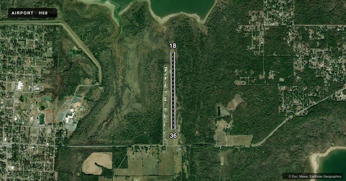
Airport sketch
Runways drawn to scale from FAA survey coordinates, rendered over satellite imagery. Not for navigation.
Approaches & charts
Services on the field
Fuel grades, oxygen, maintenance, ramp storage and lighting — as declared to the FAA by the airport operator.
Fuel & services
- Fuel
- Not available
- Oxygen (bottled)
- Not available
- Oxygen (bulk)
- Not available
- Airframe repair
- Major
- Power plant repair
- Major
Ramp & ground
- Transient storage
- Tie-down
- Landing fee
- No fee published
- Customs
- Not available
- Lighting schedule
- SEE RMK
- Beacon schedule
- SS-SR
- Beacon
- White / Green (civil land)(WG)
- Wind indicator
- Yes
- Segmented circle
- Yes
Fuel & FBOs
Cheapest 100LL and Jet A on the field and nearby. Always confirm with the FBO before taxi.
Airport notes
Surface conditions, obstructions, local procedures, lighting outages and other notes published with each FAA cycle.
General notes
- ULTRALIGHTS ON & INVOF ARPT.
- FOR CD CTC MEMPHIS ARTCC AT 901-368-8453/8449.
- BIRDS AND DEER REPRTD ON AND INVOF ARPT.
Lighting notes
- PAPI RWY 18 & 36 OPER CONSLY; MIRL RWY 18/36 ON DUSK-DAWN.
Approach & departure obstructions
- 1812 FT TREE 9 FT FM RWY 18 END 69 FT LEFT OF CNTRLN.
Other notes
- PRE DATES THE ACT.
- MANAGERCITY PLANNER.
- MANAGERAFT HRS CTC 918-527-7099 OR 918-869-6150.
VFR map & nearby airports
VFR sectional. Tap any ICAO chip to open that airport.
Key facts · H68
Answer card- ICAO
- H68
- Name
- HEFNER-EASLEY
- Location
- WAGONER, OKLAHOMA
- Elevation
- 598.9 ft MSL
- Traffic pattern altitude
- 1,598.9 ft MSL (1,000 AGL)
- Control tower
- Non-towered (use CTAF)
- Total runways
- 1
- Longest runway
- 18/36 · 3,401 ft
- Published ILS approaches
- 0
- Published frequencies
- 3
- Magnetic variation
- 4°
- Current flight rules
- VFR
- Current wind
- 230° at 7 kt
- Favored runway now
- RWY 18
Hefner-Easley Airport is in Wagoner, Oklahoma. The field elevation is 598.9 ft MSL. It has one runway. Runway 18/36 is 3,401 ft long with an asphalt surface. The airport is not towered. CTAF is 122.9. Approach and departure service is through Tulsa on 119.1 or 360.825.
No ILS approaches are published here. Pattern altitude is not published in the Chart Supplement. For light piston ops, use the standard 1,000 ft AGL pattern unless local guidance says otherwise. That puts the pattern at about 1,599 ft MSL based on the field elevation.
The published remarks matter here. A 30-foot tree line sits 135 feet left and right of the centerline near runway 18. PAPI is available on both runway ends and runs continuously. Medium intensity runway lights for 18/36 operate from dusk to dawn. Ultralights also operate on and near the airport. The north-south turf area is for taxiway use only.
No on-field FBOs are listed. Check with the airport operator or the FBO directly by phone before arrival if you need fuel or other services. For clearance delivery, contact Memphis ARTCC. After hours contact the airport manager at the number in the Chart Supplement. Expect a non-towered environment with mixed traffic and plan your pattern work carefully.