METAR & TAF 2K9
2K9 does not publish a METAR.
Showing the nearest reporting station: KOKM (OKMULGEE RGNL/PAUL AND BETTY ABBOTT FLD) · 16.9 NM away. Conditions at 2K9 may differ.
METAR · KOKM
Observed 06:35Z
KOKM 270635Z AUTO 00000KT 10SM CLR 27/21 A2992 RMK AO2 T02730205
- Wind
- 000° @ 0 kt
- Visibility
- 10 SM
- Temp / Dew
- 27°C / 21°C
- Altimeter
- 29.92 inHg
- Clouds
- CLR
- Density alt
- 2,168 ft
- Ceiling
- Unlimited
- Rules
- VFR
Airport info & contacts
Manager on record, flight service, ARTCC, attendance schedule and pattern altitude — published by the FAA and refreshed every 28 days.
Location
- From city
- 1 NM NE
- VFR sectional
- DALLAS-FT WORTH
- ARTCC
- ZKC · KANSAS CITY
- NOTAM facility
- MLC (NOTAM-D)
Airport manager
- Name
- H.E. REYNOLDS
- Phone
- 918-231-3232
- Address
- 15576 S. 289TH E AVE, COWETA OK 74429
Flight service · Hours
- FSS MLC
- MC ALESTER1-800-WX-BRIEF
- Attendance
- IREG
Frequencies
Tap any row to copy the frequency to your clipboard.
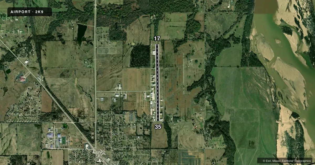
Runways & pattern
Full pagePattern entry · RWY 17
LEFT TRAFFICRunway end performance
| End | TORA | TODA | ASDA | LDA | VGSI | Approach lights | Obstruction |
|---|---|---|---|---|---|---|---|
| 17 | — | — | — | — | — | — | 58', trees, 200' from thr, 40' R of cntrln, slope 0 |
Declared distances in feet. TORA = takeoff run available, TODA = takeoff distance, ASDA = accelerate-stop, LDA = landing distance.
Airport sketch
Runways drawn to scale from FAA survey coordinates, rendered over satellite imagery. Not for navigation.
Approaches & charts
Services on the field
Fuel grades, oxygen, maintenance, ramp storage and lighting — as declared to the FAA by the airport operator.
Fuel & services
- Fuel
- 100LL
- Oxygen (bottled)
- Not available
- Oxygen (bulk)
- Not available
- Airframe repair
- Not available
- Power plant repair
- Not available
Ramp & ground
- Transient storage
- Tie-down
- Hangar
- Landing fee
- No fee published
- Lighting schedule
- SEE RMK
- Wind indicator
- Yes
- Segmented circle
- No
Fuel & FBOs
Cheapest 100LL and Jet A on the field and nearby. Always confirm with the FBO before taxi.
Airport notes
Surface conditions, obstructions, local procedures, lighting outages and other notes published with each FAA cycle.
General notes
- ULTRALIGHT ACT ON & INVOF ARPT.
- DALGT OPS ONLY.
- FOR CD CTC TULSA APPROACH AT 918-831-6714.
Lighting notes
- NSTD SOLAR ON PHOTOCELL SS-SR.
Runway surface & condition
- 17/35SOLAR RWY EDGE LGTS NSTD INTST & CONFIG.
Approach & departure obstructions
- 1756 FT TREES 170 FT FM THLD & 32 FT RIGHT.
- 3513 FT TREES 20 FT FM THR 48 FT RIGHT; 20 FT TREES 20 FT FM THR 65 FT LEFT; 15 FT RD 40 FT FM THR.
- 17ULTRALIGHT USE RIGHT TFC.
- 17SML NRS & NSTD CNTRLN.
- 35SML NRS & NSTD CNTRLN.
VFR map & nearby airports
VFR sectional. Tap any ICAO chip to open that airport.
Key facts · 2K9
Answer card- ICAO
- 2K9
- Name
- HASKELL
- Location
- HASKELL, OKLAHOMA
- Elevation
- 587 ft MSL
- Traffic pattern altitude
- 1,587 ft MSL (1,000 AGL)
- Control tower
- Non-towered (use CTAF)
- Total runways
- 1
- Longest runway
- 17/35 · 3,710 ft
- Published ILS approaches
- 0
- Published frequencies
- 1
- Magnetic variation
- 6°
- Current flight rules
- VFR
- Current wind
- 000° at 0 kt
- Favored runway now
- –
Haskell Airport sits in Haskell, Oklahoma. Field elevation is 587 ft MSL. The airport has one runway. Runway 17/35 is 3,710 ft long and asphalt. There is no control tower. CTAF is 122.9. No ILS approaches are published. Pattern altitude is not published, so use the standard 1,000 ft AGL for light piston traffic unless the current Chart Supplement says otherwise.
Haskell Airport has one on-field FBO. Haskell Airport carries AVGAS 100LL. Call (918) 231-3232 before you go if you need current service details. Published remarks matter here. Runway 35 has trees close to the threshold on both sides plus a road near the approach end. Runway 17 also has trees near the threshold. Ultralights are active on and near the airport. Ultralights use right traffic for runway 17. Runway 17 and runway 35 both have small numbers and a nonstandard centerline. Daylight operations only are published. Nonstandard solar lighting operates from sunset to sunrise. Runway edge lights are solar powered with nonstandard intensity and configuration.
This is a small, non-towered field. Expect local traffic discipline to matter. If you need clearance delivery, contact Tulsa Approach at 918-831-6714. Check the current Chart Supplement before departure for any updates to operating notes or restrictions.