METAR & TAF KMKO
Current METAR
Observed 04:53Z
KMKO 270453Z AUTO 19003KT 10SM CLR 28/22 A2994 RMK AO2 SLP128 T02830217
- Wind
- 190° @ 3 kt
- Visibility
- 10 SM
- Temp / Dew
- 28°C / 22°C
- Altimeter
- 29.94 inHg
- Clouds
- CLR
- Density alt
- 2,293 ft
- Ceiling
- Unlimited
- Rules
- VFR
Airport info & contacts
Manager on record, flight service, ARTCC, attendance schedule and pattern altitude — published by the FAA and refreshed every 28 days.
Location
- From city
- 6 NM S
- VFR sectional
- DALLAS-FT WORTH
- ARTCC
- ZFW · FORT WORTH
- NOTAM facility
- MKO (NOTAM-D)
Airport manager
- Name
- TYLER EVANS
- Phone
- 918-684-6234
- Address
- 1201 SABRE ST, MUSKOGEE OK 74403
Flight service · Hours
- FSS MLC
- MC ALESTER1-800-WX-BRIEF
- Attendance
- MON-SAT · 0800-1700
Frequencies
Tap any row to copy the frequency to your clipboard.
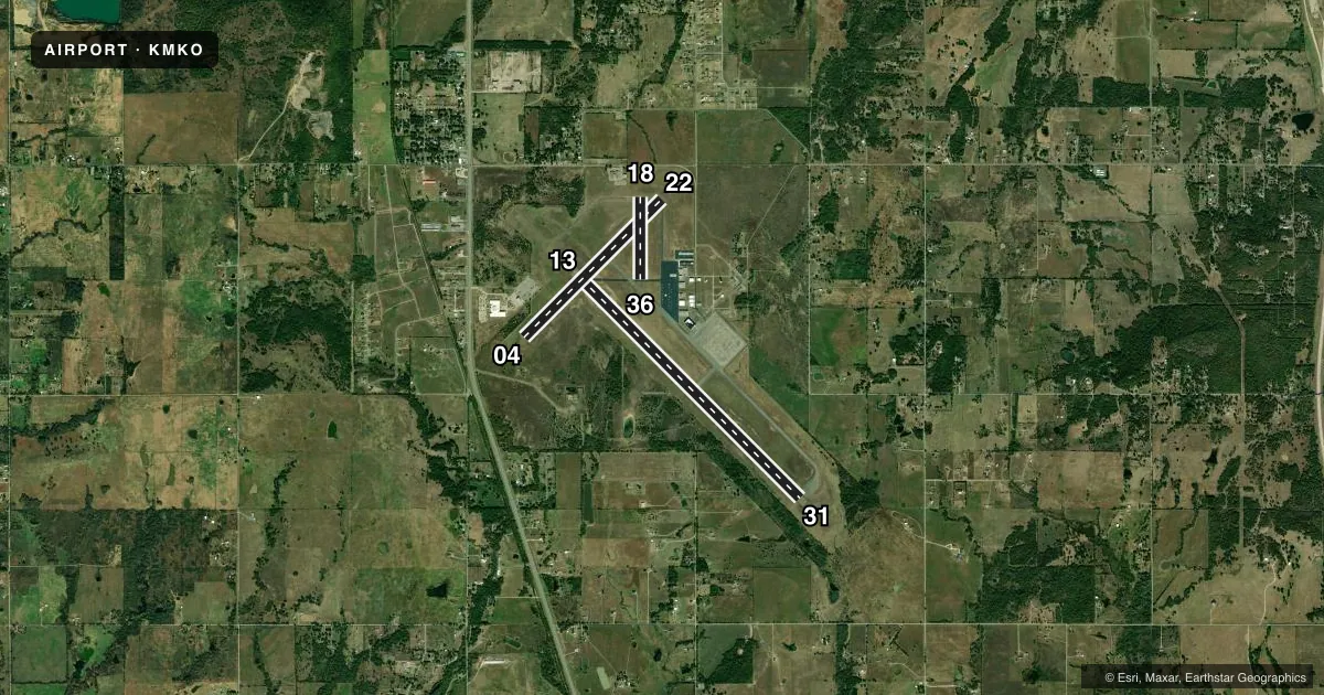
Runways & pattern
Full pagePattern entry · RWY 18
LEFT TRAFFIC| Runway | Heading (°M) | Length | Surface | Traffic |
|---|---|---|---|---|
| 13/31 | 129° / 309° | 7,202 ft | ASPH | Standard L |
| 04/22 | 39° / 219° | 4,498 ft | ASPH | Standard L |
| 18/36Favored | 174° / 354° | 1,904 ft | ASPH | Standard L |
Runway end performance
| End | TORA | TODA | ASDA | LDA | VGSI | Approach lights | Obstruction |
|---|---|---|---|---|---|---|---|
| 13 | — | — | — | — | PAPI 4-box left(3°) | — | — |
| 31 | — | — | — | — | PAPI 4-box left(3°) | MALS | — |
| 04 | — | — | — | — | — | — | 26', trees, 831' from thr, 207' R of cntrln, slope 24 |
Declared distances in feet. TORA = takeoff run available, TODA = takeoff distance, ASDA = accelerate-stop, LDA = landing distance.
Airport sketch
Runways drawn to scale from FAA survey coordinates, rendered over satellite imagery. Not for navigation.
Approaches & charts
Services on the field
Fuel grades, oxygen, maintenance, ramp storage and lighting — as declared to the FAA by the airport operator.
Fuel & services
- Fuel
- 100LLA+
- Oxygen (bottled)
- Not available
- Oxygen (bulk)
- Not available
- Airframe repair
- Minor
- Power plant repair
- Minor
- Other services
- INSTR,RNTL,SALES
Ramp & ground
- Transient storage
- Tie-down
- Hangar
- Landing fee
- No fee published
- Customs
- Not available
- Lighting schedule
- SEE RMK
- Beacon schedule
- SS-SR
- Beacon
- White / Green (civil land)(WG)
- Wind indicator
- Lighted
- Segmented circle
- Yes
Fuel & FBOs
Cheapest 100LL and Jet A on the field and nearby. Always confirm with the FBO before taxi.
Airport notes
Surface conditions, obstructions, local procedures, lighting outages and other notes published with each FAA cycle.
General notes
- TWY B CLSD TO ACFT OVER 25,000 LBS.
- OCNL COYOTES ON & INVOF RWY.
- AIRPORT USED FOR OKLAHOMA NATIONAL GUARD ATC TRAINING EVENTS - IRREGULAR SCHEDULE. CONTACT ATCT ON 118.95 WHEN OPERATIONAL.
- FOR CD IF UNA TO CTC ON FSS FREQ, CTC FORT WORTH ARTCC AT 817-858-7584.
Lighting notes
- ACTVT MALS RWY 31; REIL RWY 13; MIRL RWY 13/31 - CTAF. PAPI RWY 13/31 ON CONSLY.
Fuel notes
- 100LL100LL AVBL H24 SELF SVC.
Other notes
- MANAGERAFT HRS FUEL CALL 918-682-4101.
VFR map & nearby airports
VFR sectional. Tap any ICAO chip to open that airport.
Key facts · KMKO
Answer card- ICAO
- KMKO
- Name
- MUSKOGEE-DAVIS RGNL
- Location
- MUSKOGEE, OKLAHOMA
- Elevation
- 611.5 ft MSL
- Traffic pattern altitude
- 1,611.5 ft MSL (1,000 AGL)
- Control tower
- Non-towered (use CTAF)
- Total runways
- 3
- Longest runway
- 13/31 · 7,202 ft
- Published ILS approaches
- 0
- Published frequencies
- 2
- Magnetic variation
- 6°
- Current flight rules
- VFR
- Current wind
- 190° at 3 kt
- Favored runway now
- RWY 18
Muskogee-Davis Rgnl sits in Muskogee, Oklahoma. Field elevation is 611.5 ft MSL. The airport has 3 asphalt runways. The longest is 13/31 at 7,202 ft. No control tower is published for normal operations, so use CTAF 122.8 for traffic calls. No ILS approaches are published here. Pattern altitude is not published, so plan on the standard 1,000 ft AGL for light piston traffic unless the current FAA Chart Supplement says otherwise.
Davis Field Aviation is on the field. It carries 100LL and Jet A. 100LL is available 24 hours a day self-service. After-hours fuel service is also listed by phone. The published remarks matter here. Runway 31 has a malfunctioning approach lighting system. Runway 13 has runway end identifier lights. Medium intensity runway lights on 13 and 31 are controlled by CTAF. The airport also sees Oklahoma National Guard air traffic control training on an irregular schedule. Contact the tower on 118.95 when it is operating. Taxiway B is closed to aircraft over 25,000 pounds. Occasional coyotes are reported on and near the runway. For a first visit, brief the lighting, watch the runway and taxiway notes, then check the current FAA Chart Supplement before departure.