METAR & TAF KTQH
KTQH does not publish a METAR.
Showing the nearest reporting station: KMKO (MUSKOGEE-DAVIS RGNL) · 23.9 NM away. Conditions at KTQH may differ.
METAR · KMKO
Observed 12:53Z
KMKO 271253Z AUTO 16003KT 10SM CLR 27/22 A2995 RMK AO2 SLP133 T02670217
- Wind
- 160° @ 3 kt
- Visibility
- 10 SM
- Temp / Dew
- 27°C / 22°C
- Altimeter
- 29.95 inHg
- Clouds
- CLR
- Density alt
- 2,487 ft
- Ceiling
- Unlimited
- Rules
- VFR
Airport info & contacts
Manager on record, flight service, ARTCC, attendance schedule and pattern altitude — published by the FAA and refreshed every 28 days.
Location
- From city
- 2 NM NW
- VFR sectional
- DALLAS-FT WORTH
- ARTCC
- ZME · MEMPHIS
- NOTAM facility
- TQH (NOTAM-D)
Airport manager
- Name
- BRIAN LAMBERT
- Phone
- (918) 708-5600
- Address
- 2100 AIRPORT PARKWAY, TAHLEQUAH OK 74464
Flight service · Hours
- FSS MLC
- MC ALESTER1-800-WX-BRIEF
- Attendance
- MON-FRI · 0800-1700
Frequencies
Tap any row to copy the frequency to your clipboard.
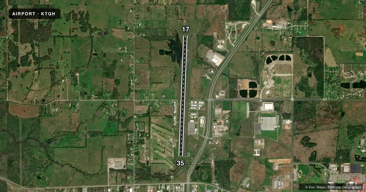
Runways & pattern
Full pagePattern entry · RWY 17
LEFT TRAFFICRunway end performance
| End | TORA | TODA | ASDA | LDA | VGSI | Approach lights | Obstruction |
|---|---|---|---|---|---|---|---|
| 17 | — | — | — | — | PAPI 4-box left(3.5°) | — | 68', trees, 1280' from thr, 343' R of cntrln, slope 15 |
| 35 | — | — | — | — | PAPI 4-box left(3°) | — | 31', trees, 239' from thr, 112' R of cntrln, slope 1 |
Declared distances in feet. TORA = takeoff run available, TODA = takeoff distance, ASDA = accelerate-stop, LDA = landing distance.
Airport sketch
Runways drawn to scale from FAA survey coordinates, rendered over satellite imagery. Not for navigation.
Approaches & charts
Services on the field
Fuel grades, oxygen, maintenance, ramp storage and lighting — as declared to the FAA by the airport operator.
Fuel & services
- Fuel
- 100LLA+
- Airframe repair
- Major
- Power plant repair
- Major
- Other services
- INSTR
Ramp & ground
- Transient storage
- Tie-down
- Hangar
- Landing fee
- No fee published
- Customs
- Not available
- Lighting schedule
- SEE RMK
- Beacon schedule
- SS-SR
- Beacon
- White / Green (civil land)(WG)
- Wind indicator
- Yes
- Segmented circle
- Yes
Fuel & FBOs
Cheapest 100LL and Jet A on the field and nearby. Always confirm with the FBO before taxi.
Airport notes
Surface conditions, obstructions, local procedures, lighting outages and other notes published with each FAA cycle.
General notes
- FOR CD CTC MEMPHIS ARTCC AT 901-368-8453/8449.
- SELF SVC CREDIT CARD FUEL H24.
Lighting notes
- ACTVT REIL RWY 17 & 35; MIRL RWY 17/35 - CTAF. PAPI RWY 17 & 35 ON CONSLY.
Approach & departure obstructions
- 3528 FT TREE 156 FT FM RWY END 131 FT L OF CNTRLN.
- 35PAPI UNUSBL BYD 8 DEGS RIGHT OF CNTRLN.
VFR map & nearby airports
VFR sectional. Tap any ICAO chip to open that airport.
Key facts · KTQH
Answer card- ICAO
- KTQH
- Name
- TAHLEQUAH MUNI
- Location
- TAHLEQUAH, OKLAHOMA
- Elevation
- 874.1 ft MSL
- Traffic pattern altitude
- 1,874.1 ft MSL (1,000 AGL)
- Control tower
- Non-towered (use CTAF)
- Total runways
- 1
- Longest runway
- 17/35 · 5,001 ft
- Published ILS approaches
- 0
- Published frequencies
- 2
- Magnetic variation
- 5°
- Current flight rules
- VFR
- Current wind
- 160° at 3 kt
- Favored runway now
- RWY 17
Tahlequah Muni sits in Tahlequah, Oklahoma. Field elevation is 874.1 ft MSL. The airport has one runway. Runway 17/35 is 5,001 ft long with an asphalt surface. There is no control tower. CTAF and UNICOM are both 122.8. No ILS approaches are published here.
Pattern altitude is not published. Use the standard 1,000 ft AGL pattern unless local procedures or the current Chart Supplement say otherwise. Runway 17 and 35 have runway end identifier lights and medium intensity runway lights. The PAPI on both ends operates continuously. The PAPI on runway 35 is unusable beyond 8 degrees right of centerline. There is also a 28-foot tree near the runway 35 end, 156 feet from the threshold and 131 feet left of centerline. That is worth keeping in mind on short final.
Tahlequah Municipal Airport is the on-field FBO. It carries 100LL and Jet A Prist. Self-serve credit card fuel is available 24 hours a day. For clearance delivery, Memphis ARTCC is the published contact. This is a non-towered field, so expect self-announce traffic and keep a close ear on 122.8. The runway is long enough for a wide range of piston and turboprop traffic. The published lighting and obstruction notes make a stabilized approach important, especially at night.