METAR & TAF 1PP
1PP does not publish a METAR.
Showing the nearest reporting station: KJSV (SALLISAW MUNI) · 20.6 NM away. Conditions at 1PP may differ.
METAR · KJSV
Observed 18:35Z
KJSV 261835Z AUTO VRB05KT 10SM CLR 36/24 A2997 RMK AO2
- Wind
- VAR @ 5 kt
- Visibility
- 10 SM
- Temp / Dew
- 36°C / 24°C
- Altimeter
- 29.97 inHg
- Clouds
- CLR
- Density alt
- 3,802 ft
- Ceiling
- Unlimited
- Rules
- VFR
Airport info & contacts
Manager on record, flight service, ARTCC, attendance schedule and pattern altitude — published by the FAA and refreshed every 28 days.
Location
- From city
- 3 NM SSW
- VFR sectional
- MEMPHIS
- ARTCC
- ZME · MEMPHIS
- NOTAM facility
- MLC
Airport manager
- Name
- JOEL BEAN
- Phone
- 918-525-2766
- Address
- PO BOX 948, TAHLEQUAH OK 74465
Flight service · Hours
- FSS MLC
- MC ALESTER1-800-WX-BRIEF
Frequencies
Tap any row to copy the frequency to your clipboard.
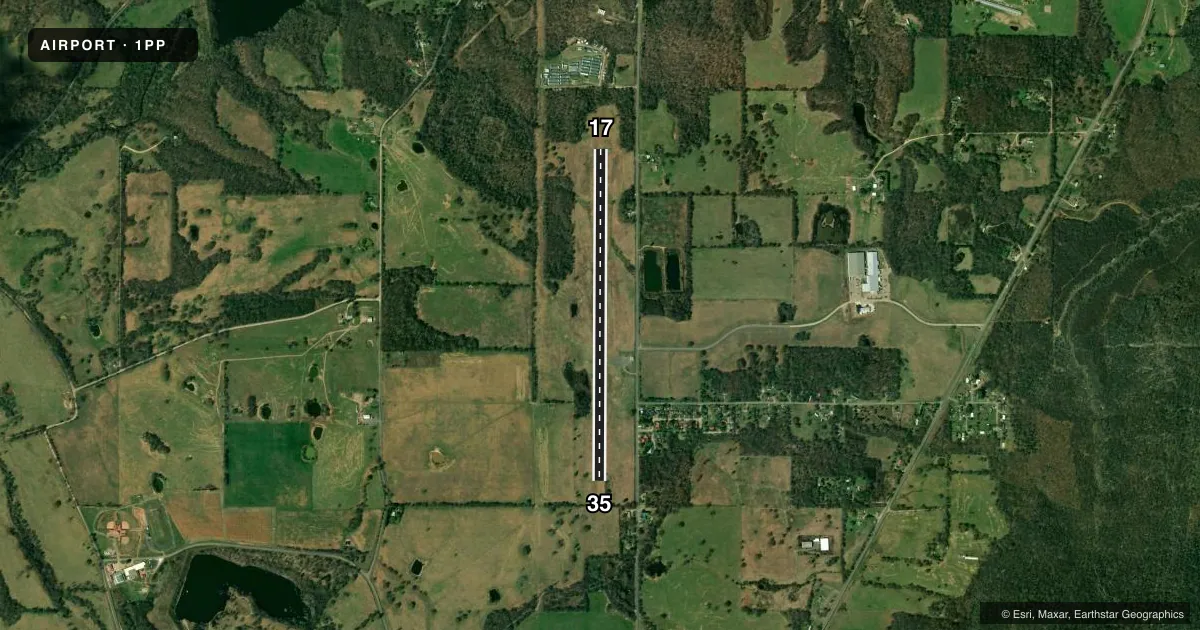
Runways & pattern
Full pagePattern entry · RWY 35
LEFT TRAFFICRunway end performance
| End | TORA | TODA | ASDA | LDA | VGSI | Approach lights | Obstruction |
|---|---|---|---|---|---|---|---|
| 17 | — | — | — | — | — | — | 30', trees, 450' from thr, 0' R of cntrln, slope 8 |
| 35 | — | — | — | — | — | — | 33', trees, 222' from thr, 60' R of cntrln, slope 0 |
Declared distances in feet. TORA = takeoff run available, TODA = takeoff distance, ASDA = accelerate-stop, LDA = landing distance.
Airport sketch
Runways drawn to scale from FAA survey coordinates, rendered over satellite imagery. Not for navigation.
Approaches & charts
Services on the field
Fuel grades, oxygen, maintenance, ramp storage and lighting — as declared to the FAA by the airport operator.
Fuel & services
- Fuel
- Not available
- Oxygen (bottled)
- Not available
- Oxygen (bulk)
- Not available
- Airframe repair
- Not available
- Power plant repair
- Not available
Ramp & ground
- Transient storage
- Not published
- Landing fee
- No fee published
- Wind indicator
- Yes
- Segmented circle
- Yes
Fuel & FBOs
Cheapest 100LL and Jet A on the field and nearby. Always confirm with the FBO before taxi.
Airport notes
Surface conditions, obstructions, local procedures, lighting outages and other notes published with each FAA cycle.
Approach & departure obstructions
- 3528 FT TREE 158 FT FM RWY 35 END 40 FT RIGHT OF APCH. 21 FT TREE 38 FT FM RWY 35 END 87 FT RIGHT OF APCH.
- 17MKGS SVRLY FADED.
- 35MRKGS SVRLY FADED.
- 17CL, NRS, WHITE X
- 35CL, NRS, WHITE X
- 17CONTROLLING OBSTRUCTION EXCEEDS A 45 DEGREE SLOPE
Other notes
- THE CRACKS IN THE RWY NEED TO BE REPAIRED. NUMBERS NEED REPAINTING AND CNTRLN STRIPES NEED REPAINTING. A WIND CONE NEEDS TO BE ADDED.
- 17/35SEVERE CRACKS AND VEG ON RWY
VFR map & nearby airports
VFR sectional. Tap any ICAO chip to open that airport.
Key facts · 1PP
Answer card- ICAO
- 1PP
- Name
- STILWELL / CHEROKEE NATION
- Location
- STILWELL, OKLAHOMA
- Elevation
- 1,084 ft MSL
- Traffic pattern altitude
- 2,084 ft MSL (1,000 AGL)
- Control tower
- Non-towered (use CTAF)
- Total runways
- 1
- Longest runway
- 17/35 · 4,208 ft
- Published ILS approaches
- 0
- Published frequencies
- 1
- Magnetic variation
- –
- Current flight rules
- VFR
- Current wind
- 000° at 5 kt
- Favored runway now
- RWY 35
STILWELL / CHEROKEE NATION sits in Stilwell, Oklahoma. Field elevation is 1,084 ft MSL. The airport has one runway. Runway 17/35 is 4,208 ft long and asphalt. There is no control tower. CTAF is 122.9. No ILS approaches are published here.
Pattern altitude is not published. Use standard 1,000 ft AGL for light piston traffic unless the current Chart Supplement says otherwise. That puts pattern work around 2,084 ft MSL based on the field elevation, but verify the current published pattern before you fly it. The runway remarks matter here. The Chart Supplement notes cracked pavement, faded and missing markings and vegetation on the runway. It also calls out trees near the runway 35 end. Runway 17 has a controlling obstruction that exceeds a 45 degree slope. Runway 17 and runway 35 both have a white X published, so check current status before planning a landing.
No on-field FBOs are listed. Contact the airport operator directly before arrival. Call the field on CTAF for current service status. This is a non-towered field, so expect self-announce traffic and verify runway condition carefully. For any current restrictions, lighting details, or operational changes, check the current FAA Chart Supplement before departure.