METAR & TAF 44M
44M does not publish a METAR.
Showing the nearest reporting station: KJSV (SALLISAW MUNI) · 17.3 NM away. Conditions at 44M may differ.
METAR · KJSV
Observed 13:15Z
KJSV 271315Z AUTO 09004KT 10SM CLR 28/27 A2995 RMK AO2
- Wind
- 090° @ 4 kt
- Visibility
- 10 SM
- Temp / Dew
- 28°C / 27°C
- Altimeter
- 29.95 inHg
- Clouds
- CLR
- Density alt
- 2,610 ft
- Ceiling
- Unlimited
- Rules
- VFR
Airport info & contacts
Manager on record, flight service, ARTCC, attendance schedule and pattern altitude — published by the FAA and refreshed every 28 days.
Location
- From city
- 1 NM SW
- VFR sectional
- MEMPHIS
- ARTCC
- ZME · MEMPHIS
- NOTAM facility
- MLC (NOTAM-D)
Airport manager
- Name
- CLIF HALL
- Phone
- 918-456-4121
- Address
- 213 W. DELAWARE ST STE 202, TAHLEQUAH OK 74464
Flight service · Hours
- FSS MLC
- MC ALESTER1-800-WX-BRIEF
- Attendance
- Unattended
Frequencies
Tap any row to copy the frequency to your clipboard.
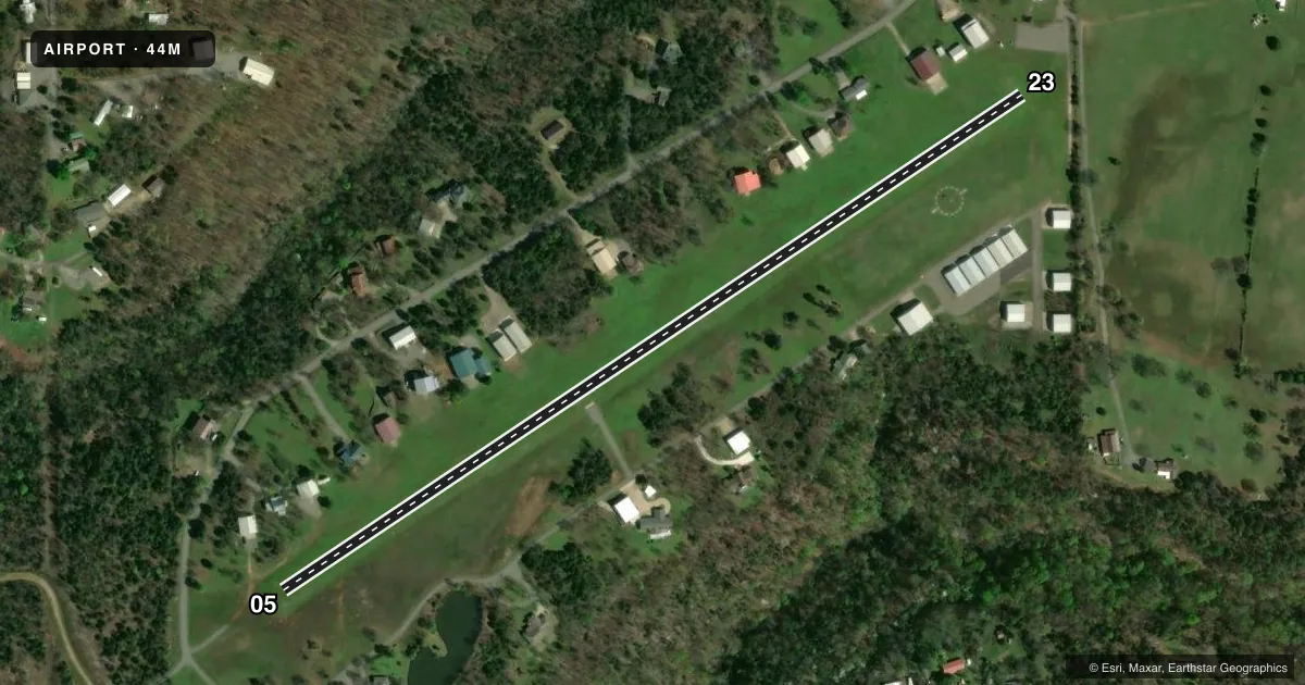
Runways & pattern
Full pagePattern entry · RWY 05
LEFT TRAFFICRunway end performance
| End | TORA | TODA | ASDA | LDA | VGSI | Approach lights | Obstruction |
|---|---|---|---|---|---|---|---|
| 05 | — | — | — | — | VASI 2-box left(3°) | — | 22', trees, 72' from thr, 92' R of cntrln, slope 3 |
| 23 | — | — | — | — | VASI 2-box left(3.5°) | — | 20', trees, 144' from thr, 0' R of cntrln, slope 7 |
Declared distances in feet. TORA = takeoff run available, TODA = takeoff distance, ASDA = accelerate-stop, LDA = landing distance.
Airport sketch
Runways drawn to scale from FAA survey coordinates, rendered over satellite imagery. Not for navigation.
Approaches & charts
Services on the field
Fuel grades, oxygen, maintenance, ramp storage and lighting — as declared to the FAA by the airport operator.
Fuel & services
- Fuel
- 100LL
- Oxygen (bottled)
- Not available
- Oxygen (bulk)
- Not available
- Airframe repair
- Not available
- Power plant repair
- Not available
Ramp & ground
- Transient storage
- Tie-down
- Landing fee
- No fee published
- Lighting schedule
- SEE RMK
- Wind indicator
- Yes
- Segmented circle
- Yes
Fuel & FBOs
Cheapest 100LL and Jet A on the field and nearby. Always confirm with the FBO before taxi.
Airport notes
Surface conditions, obstructions, local procedures, lighting outages and other notes published with each FAA cycle.
General notes
- CTN: DEER ON & INVOF RWY.
- FOR CD CTC RAZORBACK APCH 479-649-2416, WHEN APCH CLSD CTC MEMPHIS ARTCC AT 901-368-8453/8449.
Lighting notes
- ACTVT VASI RWY 05 & 23 - CTAF. LIRL RWY 05/23 DUSK-DAWN.
Fuel notes
- 100LLFOR FUEL OR AFTER HOURS ASSISTANCE CALL 918-457-4095 OR 918-931-0601.
Other notes
- 1AIRPARK IS RESIDENTIAL
- MANAGERBOARD OF COMMISSIONERS OF CHEROKEE COUNTY
VFR map & nearby airports
VFR sectional. Tap any ICAO chip to open that airport.
Key facts · 44M
Answer card- ICAO
- 44M
- Name
- TENKILLER LAKE AIRPARK
- Location
- COOKSON, OKLAHOMA
- Elevation
- 877 ft MSL
- Traffic pattern altitude
- 1,877 ft MSL (1,000 AGL)
- Control tower
- Non-towered (use CTAF)
- Total runways
- 1
- Longest runway
- 05/23 · 2,600 ft
- Published ILS approaches
- 0
- Published frequencies
- 2
- Magnetic variation
- 5°
- Current flight rules
- VFR
- Current wind
- 090° at 4 kt
- Favored runway now
- RWY 05
Tenkiller Lake Airpark sits in Cookson, Oklahoma. The field elevation is 877 ft MSL. It has one runway, 05/23, which is 2,600 ft of turf. The airport is non-towered. CTAF and UNICOM are both 122.8. No ILS approaches are published here.
The pattern altitude is not published. Use the standard 1,000 ft AGL pattern unless current local guidance says otherwise. That puts the light piston pattern at 1,877 ft MSL based on the field elevation. The on-field FBO is Tenkiller Lake Airpark. It carries 100LL. Call the field directly at (918) 457-5444 for current service details.
A few operational notes matter here. The airpark is residential. Deer have been reported on and near the runway. VASI on 05 and 23 is activated by CTAF. Low intensity runway lights on 05 and 23 operate from dusk to dawn. For clearance delivery contact Razorback Approach. If approach is closed, contact Memphis ARTCC. Check the current FAA Chart Supplement before you go for any updated local procedures or restrictions. Turf surface, local wildlife and a non-towered environment make a good arrival brief worth the time.