METAR & TAF F08
F08 does not publish a METAR.
Showing the nearest reporting station: KMKO (MUSKOGEE-DAVIS RGNL) · 25.2 NM away. Conditions at F08 may differ.
METAR · KMKO
Observed 07:53Z
KMKO 270753Z AUTO 17003KT 10SM CLR 27/20 A2993 RMK AO2 SLP126 T02670200
- Wind
- 170° @ 3 kt
- Visibility
- 10 SM
- Temp / Dew
- 27°C / 20°C
- Altimeter
- 29.93 inHg
- Clouds
- CLR
- Density alt
- 2,215 ft
- Ceiling
- Unlimited
- Rules
- VFR
Airport info & contacts
Manager on record, flight service, ARTCC, attendance schedule and pattern altitude — published by the FAA and refreshed every 28 days.
Location
- From city
- 2 NM W
- VFR sectional
- DALLAS-FT WORTH
- ARTCC
- ZFW · FORT WORTH
- NOTAM facility
- MLC (NOTAM-D)
Airport manager
- Name
- OTTO RICE
- Phone
- 918-689-2534
- Address
- 17 HOSPITAL DRIVE, P. O. BOX 684, EUFAULA OK 74432
Flight service · Hours
- FSS MLC
- MC ALESTER1-800-WX-BRIEF
- Attendance
- Unattended
Frequencies
Tap any row to copy the frequency to your clipboard.
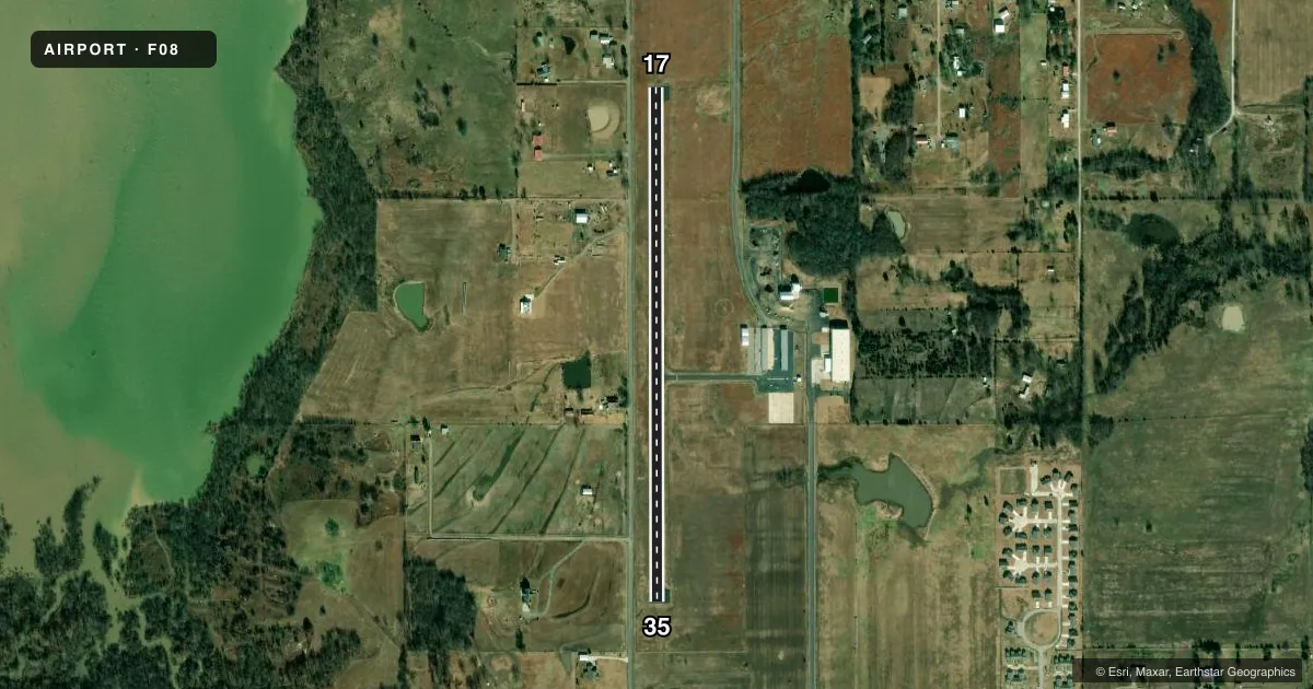
Runways & pattern
Full pagePattern entry · RWY 17
LEFT TRAFFICRunway end performance
| End | TORA | TODA | ASDA | LDA | VGSI | Approach lights | Obstruction |
|---|---|---|---|---|---|---|---|
| 17 | — | — | — | — | PAPI 2-box left(3.5°) | — | 54', trees, 870' from thr, 153' R of cntrln, slope 12 |
| 35 | — | — | — | — | PAPI 2-box left(3.5°) | — | 25', tree, 362' from thr, 132' R of cntrln, slope 6 |
Declared distances in feet. TORA = takeoff run available, TODA = takeoff distance, ASDA = accelerate-stop, LDA = landing distance.
Airport sketch
Runways drawn to scale from FAA survey coordinates, rendered over satellite imagery. Not for navigation.
Approaches & charts
Services on the field
Fuel grades, oxygen, maintenance, ramp storage and lighting — as declared to the FAA by the airport operator.
Fuel & services
- Fuel
- 100LL
- Oxygen (bottled)
- Not available
- Oxygen (bulk)
- Not available
- Airframe repair
- Not available
- Power plant repair
- Not available
Ramp & ground
- Transient storage
- Tie-down
- Landing fee
- No fee published
- Customs
- Not available
- Lighting schedule
- SEE RMK
- Beacon schedule
- SS-SR
- Beacon
- White / Green (civil land)(WG)
- Wind indicator
- Yes
- Segmented circle
- Yes
Fuel & FBOs
Cheapest 100LL and Jet A on the field and nearby. Always confirm with the FBO before taxi.
Airport notes
Surface conditions, obstructions, local procedures, lighting outages and other notes published with each FAA cycle.
General notes
- ULTRALIGHTS ON & IN VICINITY OF AIRPORT.
- FOR CD CTC FORT WORTH ARTCC AT 817-858-7584.
Lighting notes
- DUSK-DAWN. MIRL RY 17/35 PRESET LOW INTST; TO INCR INTST ACTVT- CTAF.
Fuel notes
- 100LL24 HR SELF-SERVICE
VFR map & nearby airports
VFR sectional. Tap any ICAO chip to open that airport.
Key facts · F08
Answer card- ICAO
- F08
- Name
- EUFAULA MUNI
- Location
- EUFAULA, OKLAHOMA
- Elevation
- 635 ft MSL
- Traffic pattern altitude
- 1,635 ft MSL (1,000 AGL)
- Control tower
- Non-towered (use CTAF)
- Total runways
- 1
- Longest runway
- 17/35 · 3,000 ft
- Published ILS approaches
- 0
- Published frequencies
- 1
- Magnetic variation
- 6°
- Current flight rules
- VFR
- Current wind
- 170° at 3 kt
- Favored runway now
- RWY 17
EUFAULA MUNI sits in Eufaula, Oklahoma. Field elevation is 635 ft MSL. The airport has one runway. Runway 17/35 is 3,000 ft long and paved with asphalt. There is no control tower. CTAF is 122.9.
No ILS approaches are published here. Pattern altitude is not published, so use the standard 1,000 ft AGL for light piston aircraft unless the current Chart Supplement says otherwise. The field is a simple setup. Ultralight traffic operates on and near the airport, so keep a close eye outside the cockpit on arrival and in the pattern. Runway 17/35 has medium intensity lights that sit at low intensity from dusk to dawn. Use CTAF to step the lights up if needed.
24-hour self-serve 100LL is available on the field. No on-field FBOs are listed, so verify current services with the airport operator or by calling the field before you go. For clearance delivery, contact Fort Worth ARTCC at 817-858-7584. If you are planning IFR or want current local procedures, check the current FAA Chart Supplement before departure.