METAR & TAF H05
H05 does not publish a METAR.
Showing the nearest reporting station: KMLC (MC ALESTER RGNL) · 19.3 NM away. Conditions at H05 may differ.
METAR · KMLC
Observed 12:53Z
KMLC 271253Z AUTO 20004KT 10SM CLR 27/21 A2995 RMK AO2 SLP129 T02720211
- Wind
- 200° @ 4 kt
- Visibility
- 10 SM
- Temp / Dew
- 27°C / 21°C
- Altimeter
- 29.95 inHg
- Clouds
- CLR
- Density alt
- 2,233 ft
- Ceiling
- Unlimited
- Rules
- VFR
Airport info & contacts
Manager on record, flight service, ARTCC, attendance schedule and pattern altitude — published by the FAA and refreshed every 28 days.
Location
- From city
- 4 NM W
- VFR sectional
- DALLAS-FT WORTH
- ARTCC
- ZFW · FORT WORTH
- NOTAM facility
- MLC (NOTAM-D)
Airport manager
- Name
- LORAN MAYES
- Phone
- 918-465-5361
- Address
- CITY HALL, 300 W. MAIN, WILBURTON OK 74578
Flight service · Hours
- FSS MLC
- MC ALESTER1-800-WX-BRIEF
- Attendance
- Unattended
Frequencies
Tap any row to copy the frequency to your clipboard.
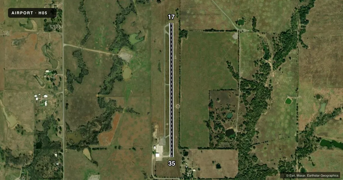
Runways & pattern
Full pagePattern entry · RWY 17
LEFT TRAFFICRunway end performance
| End | TORA | TODA | ASDA | LDA | VGSI | Approach lights | Obstruction |
|---|---|---|---|---|---|---|---|
| 17 | — | — | — | — | PAPI 2-box left(3°) | — | 31', trees, 285' from thr, 139' R of cntrln, slope 2 |
| 35 | — | — | — | — | PAPI 2-box left(3°) | — | 41', trees, 487' from thr, 207' R of cntrln, slope 7 |
Declared distances in feet. TORA = takeoff run available, TODA = takeoff distance, ASDA = accelerate-stop, LDA = landing distance.
Airport sketch
Runways drawn to scale from FAA survey coordinates, rendered over satellite imagery. Not for navigation.
Approaches & charts
Services on the field
Fuel grades, oxygen, maintenance, ramp storage and lighting — as declared to the FAA by the airport operator.
Fuel & services
- Fuel
- Not available
Ramp & ground
- Transient storage
- Tie-down
- Hangar
- Landing fee
- No fee published
- Customs
- Not available
- Lighting schedule
- SEE RMK
- Beacon schedule
- SS-SR
- Beacon
- White / Green (civil land)(WG)
- Wind indicator
- Lighted
- Segmented circle
- Yes
Fuel & FBOs
Cheapest 100LL and Jet A on the field and nearby. Always confirm with the FBO before taxi.
Airport notes
Surface conditions, obstructions, local procedures, lighting outages and other notes published with each FAA cycle.
General notes
- DEER ON & INVOF RWY.
- FOR CD CTC FORT WORTH ARTCC AT 817-858-7584.
- PARL TWY PAVEMENT FAILED; USE SOUTH CNCTR TWY TO APN.
Lighting notes
- ACTVT PAPI RWY 17 & 35; MIRL RWY 17/35 - CTAF.
Approach & departure obstructions
- 1736 FT TREE 179 FT FM THR 161 FT LEFT OF CNTRLN.
Other notes
- MANAGERMAYOR MAYES
VFR map & nearby airports
VFR sectional. Tap any ICAO chip to open that airport.
Key facts · H05
Answer card- ICAO
- H05
- Name
- WILBURTON MUNI
- Location
- WILBURTON, OKLAHOMA
- Elevation
- 669.8 ft MSL
- Traffic pattern altitude
- 1,669.8 ft MSL (1,000 AGL)
- Control tower
- Non-towered (use CTAF)
- Total runways
- 1
- Longest runway
- 17/35 · 3,000 ft
- Published ILS approaches
- 0
- Published frequencies
- 1
- Magnetic variation
- 6°
- Current flight rules
- VFR
- Current wind
- 200° at 4 kt
- Favored runway now
- RWY 17
Wilburton Muni (H05) sits in Wilburton, Oklahoma. Field elevation is 669.8 ft MSL. The airport has one runway. Runway 17/35 is 3,000 ft asphalt, so plan around a short local-field runway rather than a long cross-country strip.
There is no control tower. CTAF is 122.9. No ILS approaches are published. The pattern altitude is not published in the facts, so use the standard 1,000 ft AGL for light piston traffic unless the current Chart Supplement says otherwise. Runway lighting is available on 17 and 35. The PAPI is active for both ends, which helps on night or marginal VFR arrivals. Lighting is controlled on CTAF.
There are no on-field FBOs listed in the facts. Contact the airport operator or the field directly before arrival if you need fuel or ramp details. The published remarks also note a failed parallel taxiway pavement. Use the south connector taxiway to reach the apron. Watch for deer on and near the runway. Runway 17 also has a tree obstruction near the threshold, so give yourself a careful look on final. For clearance delivery, the remarks list Fort Worth ARTCC at 817-858-7584.