METAR & TAF KMLC
Current METAR
Observed 12:53Z
KMLC 271253Z AUTO 20004KT 10SM CLR 27/21 A2995 RMK AO2 SLP129 T02720211
- Wind
- 200° @ 4 kt
- Visibility
- 10 SM
- Temp / Dew
- 27°C / 21°C
- Altimeter
- 29.95 inHg
- Clouds
- CLR
- Density alt
- 2,359 ft
- Ceiling
- Unlimited
- Rules
- VFR
Airport info & contacts
Manager on record, flight service, ARTCC, attendance schedule and pattern altitude — published by the FAA and refreshed every 28 days.
Location
- From city
- 3 NM SW
- VFR sectional
- DALLAS-FT WORTH
- ARTCC
- ZFW · FORT WORTH
- NOTAM facility
- MLC (NOTAM-D)
Airport manager
- Name
- ERIC SUSKI
- Phone
- 918-470-4996
- Address
- 104 AIRPORT DR, MCALESTER OK 74501
Flight service · Hours
- FSS MLC
- MC ALESTER1-800-WX-BRIEF
- Attendance
- 0800-1700
Frequencies
Tap any row to copy the frequency to your clipboard.
Runways & pattern
Full pagePattern entry · RWY 20
LEFT TRAFFICRunway end performance
| End | TORA | TODA | ASDA | LDA | VGSI | Approach lights | Obstruction |
|---|---|---|---|---|---|---|---|
| 02 | — | — | — | — | PAPI 4-box left(3°) | MALS | 59', tree, 1608' from thr, 28' R of cntrln, slope 23 |
| 20 | — | — | — | — | PAPI 4-box left(3°) | — | — |
Declared distances in feet. TORA = takeoff run available, TODA = takeoff distance, ASDA = accelerate-stop, LDA = landing distance.
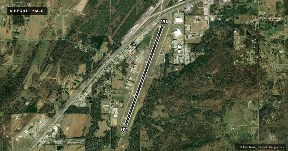
Airport sketch
Runways drawn to scale from FAA survey coordinates, rendered over satellite imagery. Not for navigation.
Approaches & charts
Services on the field
Fuel grades, oxygen, maintenance, ramp storage and lighting — as declared to the FAA by the airport operator.
Fuel & services
- Fuel
- 100LLA+
- Airframe repair
- Major
- Power plant repair
- Major
- Other services
- AMB,INSTR,RNTL
Ramp & ground
- Transient storage
- Tie-down
- Hangar
- Landing fee
- No fee published
- Customs
- Not available
- Lighting schedule
- SEE RMK
- Beacon schedule
- SS-SR
- Beacon
- White / Green (civil land)(WG)
- Wind indicator
- Lighted
- Segmented circle
- No
Fuel & FBOs
Cheapest 100LL and Jet A on the field and nearby. Always confirm with the FBO before taxi.
Airport notes
Surface conditions, obstructions, local procedures, lighting outages and other notes published with each FAA cycle.
General notes
- FOR CD IF UNA TO CTC ON FSS FREQ, CTC FORT WORTH ARTCC AT 817-858-7584.
- WILDLIFE ON & INVOF ARPT.
- PILOTS CONDUCTING EFVS OPS; BE AWARE LED ALS IN USE RWY 02.
Lighting notes
- ACTVT MALS RWY 02; REIL RWY 20; PAPI RWY 02 & 20; MIRL RWY 02/20 - CTAF. MIRL RWY 02/20 SET LOW INTST, INCR INTST - CTAF.
Other notes
- ESTAB PRIOR TO 1959.
- 1AFT HR - 918-329-8330.
VFR map & nearby airports
VFR sectional. Tap any ICAO chip to open that airport.
Key facts · KMLC
Answer card- ICAO
- KMLC
- Name
- MC ALESTER RGNL
- Location
- MC ALESTER, OKLAHOMA
- Elevation
- 770.8 ft MSL
- Traffic pattern altitude
- 1,770.8 ft MSL (1,000 AGL)
- Control tower
- Non-towered (use CTAF)
- Total runways
- 1
- Longest runway
- 02/20 · 5,602 ft
- Published ILS approaches
- 0
- Published frequencies
- 2
- Magnetic variation
- 2°
- Current flight rules
- VFR
- Current wind
- 200° at 4 kt
- Favored runway now
- RWY 20
McAlester Regional Airport sits in McAlester, Oklahoma. Field elevation is 770.8 ft MSL. The airport has one runway. Runway 02/20 is 5,602 ft long with a concrete surface. There is no control tower, so expect self-announce traffic on CTAF 122.95. No ILS approaches are published here.
The published pattern altitude is not published. Use the standard 1,000 ft AGL pattern for light piston aircraft unless current local guidance says otherwise. The field has medium intensity runway lights on both ends. They are controlled on CTAF. The approach lighting system is active on runway 02. Runway 20 has runway end identifier lights. PAPI is installed on both runway ends. Wildlife is present on and near the airport. Keep a sharp scan on taxi, takeoff and landing.
McAlester Regional Airport is the on-field FBO. It carries 100LL and Jet A. After hours contact is by phone at 918-329-8330. If you need clearance delivery help and cannot reach Flight Service, the published contact is Fort Worth Center at 817-858-7584. Check the current FAA Chart Supplement for any changes before you go.