METAR & TAF KAQR
KAQR does not publish a METAR.
Showing the nearest reporting station: KDUA (DURANT RGNL/EAKER FLD) · 30.1 NM away. Conditions at KAQR may differ.
METAR · KDUA
Observed 13:15Z
KDUA 271315Z AUTO 19006KT 10SM CLR 27/23 A2998 RMK AO2
- Wind
- 190° @ 6 kt
- Visibility
- 10 SM
- Temp / Dew
- 27°C / 23°C
- Altimeter
- 29.98 inHg
- Clouds
- CLR
- Density alt
- 2,097 ft
- Ceiling
- Unlimited
- Rules
- VFR
Airport info & contacts
Manager on record, flight service, ARTCC, attendance schedule and pattern altitude — published by the FAA and refreshed every 28 days.
Location
- From city
- 1 NM NW
- VFR sectional
- DALLAS-FT WORTH
- ARTCC
- ZFW · FORT WORTH
- NOTAM facility
- AQR (NOTAM-D)
Airport manager
- Name
- DANNY DELAY
- Phone
- 580-889-3341
- Address
- 353 EAST A STREET, P. O. BOX 900, ATOKA OK 74525
Flight service · Hours
- FSS MLC
- MC ALESTER1-800-WX-BRIEF
- Attendance
- Unattended
Frequencies
Tap any row to copy the frequency to your clipboard.
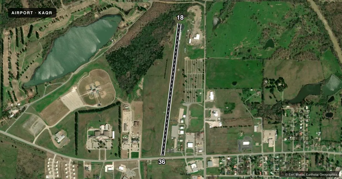
Runways & pattern
Full pagePattern entry · RWY 18
LEFT TRAFFICRunway end performance
| End | TORA | TODA | ASDA | LDA | VGSI | Approach lights | Obstruction |
|---|---|---|---|---|---|---|---|
| 18 | 3,015' | 3,015' | 3,015' | 2,818' | PAPI 2-box left(3°) | — | 25', trees, 237' from thr, 64' R of cntrln, slope 1 |
| 36 | 3,015' | 3,015' | 3,015' | 2,782' | PAPI 2-box left(3°) | — | 46', trees, 923' from thr, 81' R of cntrln, slope 15 |
Declared distances in feet. TORA = takeoff run available, TODA = takeoff distance, ASDA = accelerate-stop, LDA = landing distance.
Airport sketch
Runways drawn to scale from FAA survey coordinates, rendered over satellite imagery. Not for navigation.
Approaches & charts
Services on the field
Fuel grades, oxygen, maintenance, ramp storage and lighting — as declared to the FAA by the airport operator.
Fuel & services
- Fuel
- 100LL
Ramp & ground
- Transient storage
- Tie-down
- Landing fee
- No fee published
- Lighting schedule
- SEE RMK
- Beacon schedule
- SS-SR
- Beacon
- White / Green (civil land)(WG)
- Wind indicator
- Yes
- Segmented circle
- No
Fuel & FBOs
Cheapest 100LL and Jet A on the field and nearby. Always confirm with the FBO before taxi.
Airport notes
Surface conditions, obstructions, local procedures, lighting outages and other notes published with each FAA cycle.
General notes
- FOR CD CTC FORT WORTH ARTCC AT 817-858-7584.
Lighting notes
- MIRL RWY 18/36 OPS SS-SR; ACTVT PAPI RWY 18 - CTAF.
Fuel notes
- 100LLAVBL H24 HR WITH CREDIT CARD.
Approach & departure obstructions
- 1820 FT TREES EAST SIDE RWY 18 END.
- 3618 FT HWY 45 FT FM RWY END; 3 FT FENCE 10 FT FM RWY END APCH CLNC SLOPE 16:1 TO THLD.
- 36PAPI UNUSBL BYD 6 DEGS LEFT & 9 DEGS RIGHT OF CNTRLN.
- 18APCH SLOPE TO THLD 21:1 DUE TO 18 FT TREES 147 FT FM RWY END 66 FT LEFT OF EXTDD CNTRLN.
Other notes
- MANAGER580-889-3250.
VFR map & nearby airports
VFR sectional. Tap any ICAO chip to open that airport.
Key facts · KAQR
Answer card- ICAO
- KAQR
- Name
- ATOKA MUNI
- Location
- ATOKA, OKLAHOMA
- Elevation
- 590 ft MSL
- Traffic pattern altitude
- 1,590 ft MSL (1,000 AGL)
- Control tower
- Non-towered (use CTAF)
- Total runways
- 1
- Longest runway
- 18/36 · 3,015 ft
- Published ILS approaches
- 0
- Published frequencies
- 1
- Magnetic variation
- 6°
- Current flight rules
- VFR
- Current wind
- 190° at 6 kt
- Favored runway now
- RWY 18
Atoka Muni sits in Atoka, Oklahoma. Field elevation is 590 ft MSL. The airport has one runway. Runway 18/36 is 3,015 ft long and asphalt. There is no control tower. CTAF is 122.9. No ILS approaches are published here.
Pattern altitude is not published. Use standard 1,000 ft AGL for light piston operations unless the current Chart Supplement says otherwise. The on-field FBO is Atoka Municipal Airport. It carries 100LL. Fuel is available 24 hours with credit card. The manager phone number is the same as the airport phone number in the remarks.
A first-time pilot should pay close attention to the runway ends. Runway 18 has 20-foot trees on the east side near the departure end. The approach to 18 is constrained by those trees. Runway 36 has an 18-foot highway close to the end of the runway. There is also a 3-foot fence near that end. The airport uses medium intensity runway lights from sunset to sunrise. The PAPI on runway 18 is activated by CTAF. For clearance delivery, contact Fort Worth ARTCC. If you are planning IFR or want the latest operational details, check the current FAA Chart Supplement before you go.