METAR & TAF KDUA
Current METAR
Observed 13:15Z
KDUA 271315Z AUTO 19006KT 10SM CLR 27/23 A2998 RMK AO2
- Wind
- 190° @ 6 kt
- Visibility
- 10 SM
- Temp / Dew
- 27°C / 23°C
- Altimeter
- 29.98 inHg
- Clouds
- CLR
- Density alt
- 2,232 ft
- Ceiling
- Unlimited
- Rules
- VFR
Airport info & contacts
Manager on record, flight service, ARTCC, attendance schedule and pattern altitude — published by the FAA and refreshed every 28 days.
Location
- From city
- 3 NM SW
- VFR sectional
- DALLAS-FT WORTH
- ARTCC
- ZFW · FORT WORTH
- NOTAM facility
- DUA (NOTAM-D)
Airport manager
- Name
- DENIS GODFREY
- Phone
- 580-920-0574
- Address
- 10 WALDRON DR, DURANT OK 74701
Flight service · Hours
- FSS MLC
- MC ALESTER1-800-WX-BRIEF
- Attendance
- 0700-1800
Frequencies
Tap any row to copy the frequency to your clipboard.
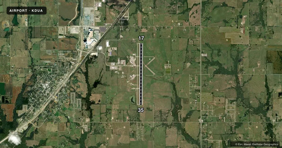
Runways & pattern
Full pagePattern entry · RWY 17
LEFT TRAFFICRunway end performance
| End | TORA | TODA | ASDA | LDA | VGSI | Approach lights | Obstruction |
|---|---|---|---|---|---|---|---|
| 17 | — | — | — | — | PAPI 4-box left(3°) | ODALS | 33', trees, 1164' from thr, 356' R of cntrln, slope 29 |
| 35 | — | — | — | — | PAPI 4-box left(3°) | — | 31', trees, 1028' from thr, 437' R of cntrln, slope 26 |
Declared distances in feet. TORA = takeoff run available, TODA = takeoff distance, ASDA = accelerate-stop, LDA = landing distance.
Airport sketch
Runways drawn to scale from FAA survey coordinates, rendered over satellite imagery. Not for navigation.
Approaches & charts
Services on the field
Fuel grades, oxygen, maintenance, ramp storage and lighting — as declared to the FAA by the airport operator.
Fuel & services
- Fuel
- 100LLA+
- Oxygen (bottled)
- High pressure
- Oxygen (bulk)
- High pressure
- Airframe repair
- Major
- Power plant repair
- Major
- Other services
- AVNCS,INSTR,RNTL,SALES
Ramp & ground
- Transient storage
- Tie-down
- Hangar
- Landing fee
- No fee published
- Customs
- Not available
- Lighting schedule
- SEE RMK
- Beacon schedule
- SS-SR
- Beacon
- White / Green (civil land)(WG)
- Wind indicator
- Lighted
- Segmented circle
- Yes
Fuel & FBOs
Cheapest 100LL and Jet A on the field and nearby. Always confirm with the FBO before taxi.
Airport notes
Surface conditions, obstructions, local procedures, lighting outages and other notes published with each FAA cycle.
General notes
- 372 FT TWR 2.5 MI N.
- STUDENT TRNG INVOF ARPT & OVR LAKE TEXOMA.
- FOR CD CTC FORT WORTH ARTCC AT 817-858-7584.
- ULTRALIGHT ACT INVOF ARPT.
Lighting notes
- ACTVT ODALS RWY 17; MIRL RWY 17/35; TWY LGTS - CTAF. PAPI RWY 17 & 35 ON CONSLY.
Fuel notes
- 100LLAFT HR FUEL - 580-579-5024.
Runway surface & condition
- 17/35PCR VALUE: 226/R/B/X/T
Other notes
- ARPT ESTAB PRIOR TO 1959.
- 1AFT HR ON REQ.
- MANAGERAFT HR - 580-579-5024.
VFR map & nearby airports
VFR sectional. Tap any ICAO chip to open that airport.
Key facts · KDUA
Answer card- ICAO
- KDUA
- Name
- DURANT RGNL/EAKER FLD
- Location
- DURANT, OKLAHOMA
- Elevation
- 699.1 ft MSL
- Traffic pattern altitude
- 1,699.1 ft MSL (1,000 AGL)
- Control tower
- Non-towered (use CTAF)
- Total runways
- 1
- Longest runway
- 17/35 · 6,800 ft
- Published ILS approaches
- 0
- Published frequencies
- 2
- Magnetic variation
- 5°
- Current flight rules
- VFR
- Current wind
- 190° at 6 kt
- Favored runway now
- RWY 17
Durant Rgnl/Eaker Fld sits in Durant, Oklahoma at 699.1 ft MSL. It has one runway, 17/35, which is 6,800 ft long and paved with asphalt. The field is non-towered. CTAF and UNICOM are both 123.05. No ILS approaches are published here.
Pattern altitude is not published, so use the standard 1,000 ft AGL for light piston traffic unless the current Chart Supplement says otherwise. The field has a 372 ft tower 2.5 miles north, so keep that in mind on departure and arrival. Ultralight activity is also reported in the area. Student training happens near the airport and over Lake Texoma, so expect mixed traffic.
Durant Regional Airport is on the field. It carries 100LL and Jet A. After-hours fuel service is available by calling the number in the Chart Supplement. Runway 17 has activated omnidirectional approach lighting. Medium intensity runway lights are on both ends. Taxiway lights are controlled by CTAF. PAPI is on runways 17 and 35 and is on continuously. For clearance delivery, contact Fort Worth ARTCC before departure if you need IFR handling. The pavement classification rating for 17/35 is published as 226 rigid B X T.