METAR & TAF KSWI
KSWI does not publish a METAR.
Showing the nearest reporting station: KGYI (NORTH TEXAS RGNL/PERRIN FLD) · 7.0 NM away. Conditions at KSWI may differ.
METAR · KGYI
Observed 04:35Z
KGYI 270435Z AUTO 16010KT 10SM CLR 29/20 A2996 RMK AO2 T02950201 $
- Wind
- 160° @ 10 kt
- Visibility
- 10 SM
- Temp / Dew
- 29°C / 20°C
- Altimeter
- 29.96 inHg
- Clouds
- CLR
- Density alt
- 2,556 ft
- Ceiling
- Unlimited
- Rules
- VFR
Airport info & contacts
Manager on record, flight service, ARTCC, attendance schedule and pattern altitude — published by the FAA and refreshed every 28 days.
Location
- From city
- 1 NM SE
- VFR sectional
- DALLAS-FT WORTH
- ARTCC
- ZFW · FORT WORTH
- NOTAM facility
- FTW (NOTAM-D)
Airport manager
- Name
- JOHN HOOKER
- Phone
- 903-868-4412
- Address
- 1200 S. DEWEY AVE, SHERMAN TX 75090
Flight service · Hours
- FSS FTW
- FORT WORTH1-800-WX-BRIEF
- Attendance
- 0800-1700
Frequencies
Tap any row to copy the frequency to your clipboard.
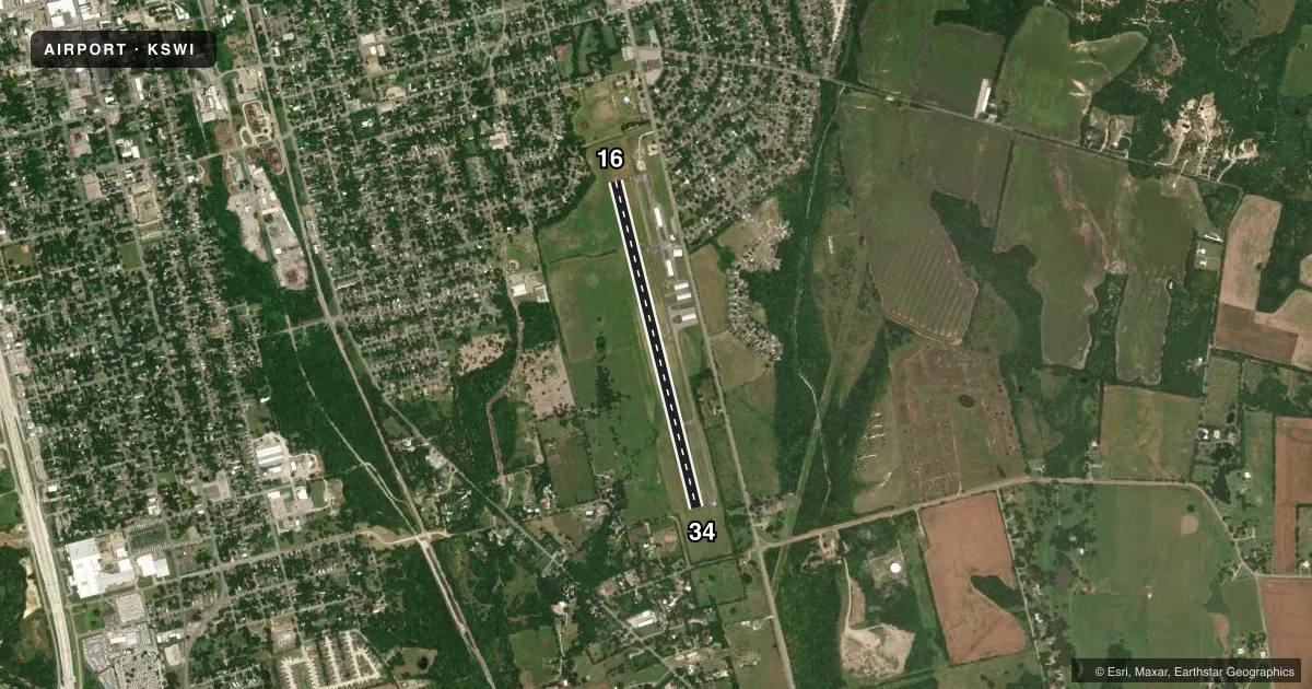
Runways & pattern
Full pagePattern entry · RWY 16
LEFT TRAFFICRunway end performance
| End | TORA | TODA | ASDA | LDA | VGSI | Approach lights | Obstruction |
|---|---|---|---|---|---|---|---|
| 16 | — | — | — | — | — | — | 30', trees, 530' from thr, 250' R of cntrln, slope 10 |
| 34 | — | — | — | — | — | — | 14', pline, 700' from thr, 0' R of cntrln, slope 34 |
Declared distances in feet. TORA = takeoff run available, TODA = takeoff distance, ASDA = accelerate-stop, LDA = landing distance.
Airport sketch
Runways drawn to scale from FAA survey coordinates, rendered over satellite imagery. Not for navigation.
Approaches & charts
Services on the field
Fuel grades, oxygen, maintenance, ramp storage and lighting — as declared to the FAA by the airport operator.
Fuel & services
- Fuel
- 100LL
- Oxygen (bottled)
- Not available
- Oxygen (bulk)
- Not available
- Airframe repair
- Major
- Power plant repair
- Major
Ramp & ground
- Transient storage
- Tie-down
- Landing fee
- No fee published
- Customs
- Not available
- Lighting schedule
- SEE RMK
- Beacon schedule
- SS-SR
- Beacon
- White / Green (civil land)(WG)
- Wind indicator
- Lighted
- Segmented circle
- Yes
Fuel & FBOs
Cheapest 100LL and Jet A on the field and nearby. Always confirm with the FBO before taxi.
Airport notes
Surface conditions, obstructions, local procedures, lighting outages and other notes published with each FAA cycle.
General notes
- CITY ORDINANCE MANDATES ALL TAKE-OFFS ON RY 34 COMMENCE AT THLD MARKINGS. HIGH SPEED, LOW LEVEL PASSES ARE PROHIBITED.
- FOR CD CTC FORT WORTH ARTCC AT 817-858-7584.
Lighting notes
- MIRL RWY 16/34 PRESET LOW INTST; TO INCR INTST AND ACTVT - CTAF.
Fuel notes
- 100LLFUEL SELF SERVE.
Approach & departure obstructions
- 3422 FT TREES, 0-199 FT DSTC, 220 FT L.
- 16MKGS DISCOLORED.
- 34MKGS DISCOLORED.
Other notes
- 16/34EXTSV CRACKING.
VFR map & nearby airports
VFR sectional. Tap any ICAO chip to open that airport.
Key facts · KSWI
Answer card- ICAO
- KSWI
- Name
- SHERMAN MUNI
- Location
- SHERMAN, TEXAS
- Elevation
- 746.1 ft MSL
- Traffic pattern altitude
- 1,746.1 ft MSL (1,000 AGL)
- Control tower
- Non-towered (use CTAF)
- Total runways
- 1
- Longest runway
- 16/34 · 4,000 ft
- Published ILS approaches
- 0
- Published frequencies
- 2
- Magnetic variation
- 3°
- Current flight rules
- VFR
- Current wind
- 160° at 10 kt
- Favored runway now
- RWY 16
Sherman Muni is in Sherman, Texas. The field elevation is 746.1 ft MSL. It has one runway, 16/34, which is 4,000 ft long. There is no control tower. CTAF and UNICOM are both 122.8. No ILS approaches are published here.
The pattern altitude is not published. Use the standard 1,000 ft AGL for light piston traffic unless the current FAA Chart Supplement says otherwise. Sherman Municipal Airport is the on-field FBO. It carries AVGAS 100LL. Fuel is self-serve. Call (903) 891-4035 before arrival if you need current ramp or fuel details.
Plan for a few local quirks. Runway 16/34 has extensive cracking. Runway 16 and runway 34 markings are discolored. Runway 34 has 22 ft trees off the left side near the approach end. City ordinance says all takeoffs on runway 34 must start at the threshold markings. High speed low level passes are prohibited. The runway lights on 16/34 are preset to low intensity. Use the CTAF to increase intensity and activate them. For clearance delivery, contact Fort Worth ARTCC at 817-858-7584. This is a non-towered field, so keep your radio work tight and verify current procedures before you go.