METAR & TAF T80
T80 does not publish a METAR.
Showing the nearest reporting station: KTKI (MCKINNEY NTL) · 13.9 NM away. Conditions at T80 may differ.
METAR · KTKI
Observed 08:53Z
KTKI 270853Z AUTO 13003KT 10SM CLR 24/21 A2993 RMK AO2 SLP127 T02440211 58007
- Wind
- 130° @ 3 kt
- Visibility
- 10 SM
- Temp / Dew
- 24°C / 21°C
- Altimeter
- 29.93 inHg
- Clouds
- CLR
- Density alt
- 1,998 ft
- Ceiling
- Unlimited
- Rules
- VFR
Airport info & contacts
Manager on record, flight service, ARTCC, attendance schedule and pattern altitude — published by the FAA and refreshed every 28 days.
Location
- From city
- 5 NM NE
- VFR sectional
- DALLAS-FT WORTH
- ARTCC
- ZFW · FORT WORTH
- NOTAM facility
- FTW (NOTAM-D)
Airport manager
- Name
- BOBBY BISHOP
- Phone
- 214-280-4408
- Address
- 8955 CR 135, CELINA TX 75009
Flight service · Hours
- FSS FTW
- FORT WORTH1-800-WX-BRIEF
- Attendance
- Unattended
Frequencies
Tap any row to copy the frequency to your clipboard.
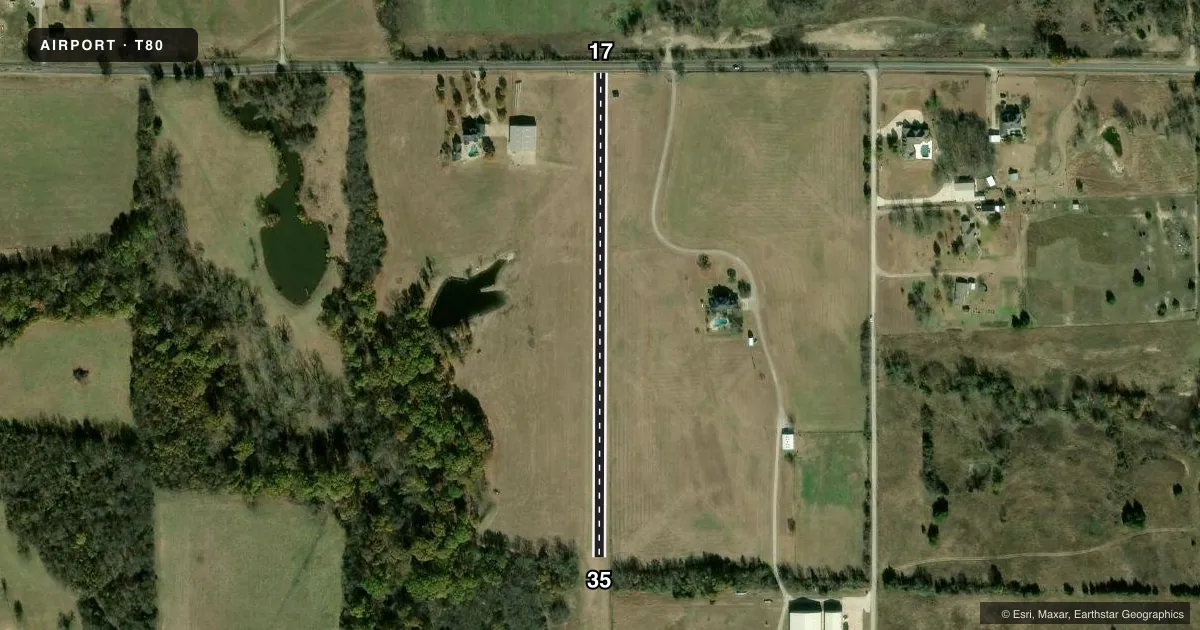
Runways & pattern
Full pagePattern entry · RWY 17
LEFT TRAFFICRunway end performance
| End | TORA | TODA | ASDA | LDA | VGSI | Approach lights | Obstruction |
|---|---|---|---|---|---|---|---|
| 17 | — | — | — | — | — | — | 34', pole, 10' from thr, 67' R of cntrln, slope 0 |
| 35 | — | — | — | — | — | — | 70', trees, 0' from thr, 60' R of cntrln, slope 0 |
Declared distances in feet. TORA = takeoff run available, TODA = takeoff distance, ASDA = accelerate-stop, LDA = landing distance.
Airport sketch
Runways drawn to scale from FAA survey coordinates, rendered over satellite imagery. Not for navigation.
Approaches & charts
Services on the field
Fuel grades, oxygen, maintenance, ramp storage and lighting — as declared to the FAA by the airport operator.
Fuel & services
- Fuel
- Not available
Ramp & ground
- Transient storage
- Not published
- Wind indicator
- Yes
- Segmented circle
- No
Fuel & FBOs
Cheapest 100LL and Jet A on the field and nearby. Always confirm with the FBO before taxi.
Airport notes
Surface conditions, obstructions, local procedures, lighting outages and other notes published with each FAA cycle.
General notes
- FOR CD CTC LONE STAR APCH AT 972-615-2799.
- RWY 17 PLINE BURIED ACRS APCH. 35 FT POLES 0 FT DSTC, 87 FT R, 96 FT L.
Other notes
- PRVDD PLINES ON NORTH END BURIED.
- 17/35RWY SOFT AFT RAIN. CALL AMGR FOR FLD CONDS.
VFR map & nearby airports
VFR sectional. Tap any ICAO chip to open that airport.
Key facts · T80
Answer card- ICAO
- T80
- Name
- BISHOP'S LANDING
- Location
- CELINA, TEXAS
- Elevation
- 750 ft MSL
- Traffic pattern altitude
- 1,750 ft MSL (1,000 AGL)
- Control tower
- Non-towered (use CTAF)
- Total runways
- 1
- Longest runway
- 17/35 · 1,580 ft
- Published ILS approaches
- 0
- Published frequencies
- 1
- Magnetic variation
- 6°
- Current flight rules
- VFR
- Current wind
- 130° at 3 kt
- Favored runway now
- RWY 17
Bishop's Landing (T80) sits in Celina, Texas. Field elevation is 750 ft MSL. It has one runway, 17/35, with a longest length of 1,580 ft. This is a non-towered field. CTAF is 122.9.
No ILS approaches are published here. Pattern altitude is not published in the facts. Use the current Chart Supplement before you fly. The runway is turf. Published remarks say the surface can be soft after rain. Call the airport manager for field conditions if you are unsure. The north end power lines are buried. There are also buried power lines on the north end. Runway 17 has buried power line information in the approach area. The published remarks also note 35 ft poles near the runway 17 approach path. That is worth a close look on arrival and departure.
There are no on-field FBOs listed in the facts. For clearance delivery, contact Lone Star Approach at 972-615-2799. If you are planning a first visit, check the current Chart Supplement for pattern altitude, any local procedures and any other operational notes before you go. Turf, a short runway and soft-field conditions after rain make it a field where a current look matters.