METAR & TAF 9S1
9S1 does not publish a METAR.
Showing the nearest reporting station: KTKI (MCKINNEY NTL) · 14.2 NM away. Conditions at 9S1 may differ.
METAR · KTKI
Observed 20:53Z
KTKI 262053Z 11010KT 10SM CLR 36/22 A2996 RMK AO2 SLP135 T03560217 56020
- Wind
- 110° @ 10 kt
- Visibility
- 10 SM
- Temp / Dew
- 36°C / 22°C
- Altimeter
- 29.96 inHg
- Clouds
- CLR
- Density alt
- 3,450 ft
- Ceiling
- Unlimited
- Rules
- VFR
Airport info & contacts
Manager on record, flight service, ARTCC, attendance schedule and pattern altitude — published by the FAA and refreshed every 28 days.
Location
- From city
- 3 NM NE
- VFR sectional
- DALLAS-FT WORTH
- ARTCC
- ZFW · FORT WORTH
- NOTAM facility
- FTW (NOTAM-D)
Airport manager
- Name
- STEWART & AVERILLE DAWSON
- Phone
- 214-803-7533
- Address
- 10000 CR 134, CELINA TX 75009
Flight service · Hours
- FSS FTW
- FORT WORTH1-800-WX-BRIEF
- Attendance
- DAWN-DUSK
Frequencies
Tap any row to copy the frequency to your clipboard.
Runways & pattern
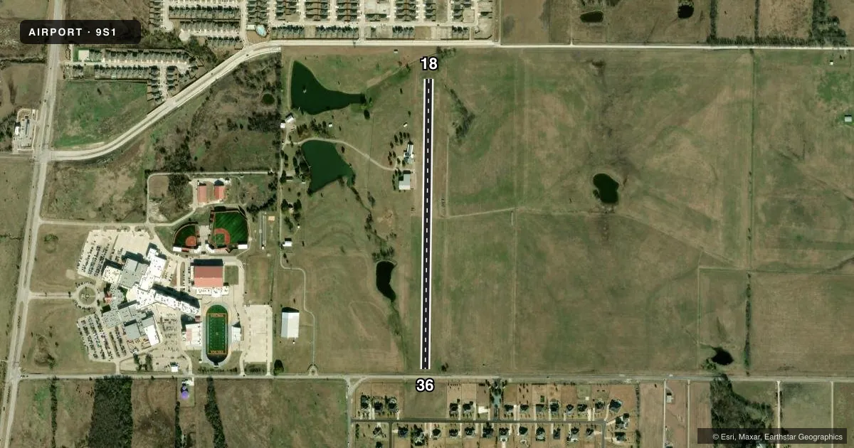
Full pagePattern entry · RWY 18
RIGHT TRAFFICRunway end performance
| End | TORA | TODA | ASDA | LDA | VGSI | Approach lights | Obstruction |
|---|---|---|---|---|---|---|---|
| 18 | — | — | — | — | — | — | 21', trees, 72' from thr, 78' R of cntrln, slope 3 |
| 36 | — | — | — | — | — | — | 5', fence, 0' from thr, 135' R of cntrln, slope 1 |
Declared distances in feet. TORA = takeoff run available, TODA = takeoff distance, ASDA = accelerate-stop, LDA = landing distance.
Airport sketch
Runways drawn to scale from FAA survey coordinates, rendered over satellite imagery. Not for navigation.
Approaches & charts
Services on the field
Fuel grades, oxygen, maintenance, ramp storage and lighting — as declared to the FAA by the airport operator.
Fuel & services
- Fuel
- Not available
Ramp & ground
- Transient storage
- Not published
- Wind indicator
- Yes
Fuel & FBOs
Cheapest 100LL and Jet A on the field and nearby. Always confirm with the FBO before taxi.
Airport notes
Surface conditions, obstructions, local procedures, lighting outages and other notes published with each FAA cycle.
General notes
- ALL TFC REMAIN WEST OF THE ARPT.
- RWY 17 - 20 FT DROP NORTH OF THR.
- FOR CD CTC LONE STAR APCH AT 972-615-2799.
Approach & departure obstructions
- 3620 FT ROAD 60 FT DSTC, 135 FT L/R.
Other notes
- PRVDD VFR OPNS, CLEAR 20:1 APCHS AND RIGHT TFC RWY 18.
VFR map & nearby airports
VFR sectional. Tap any ICAO chip to open that airport.
Key facts · 9S1
Answer card- ICAO
- 9S1
- Name
- FOUR WINDS
- Location
- CELINA, TEXAS
- Elevation
- 790 ft MSL
- Traffic pattern altitude
- 1,790 ft MSL (1,000 AGL)
- Control tower
- Non-towered (use CTAF)
- Total runways
- 1
- Longest runway
- 18/36 · 2,662 ft
- Published ILS approaches
- 0
- Published frequencies
- 1
- Magnetic variation
- –
- Current flight rules
- VFR
- Current wind
- 110° at 10 kt
- Favored runway now
- RWY 18
Four Winds Airport (9S1) sits in Celina, Texas. The field elevation is 790 ft MSL. It has one runway. Runway 18/36 is 2,662 ft long and turf. There is no control tower. CTAF is 122.9.
No ILS approaches are published here. Pattern altitude is not published in the facts, so use the current FAA Chart Supplement before you go. Published remarks matter at this field. Clearance delivery is handled through Lone Star Approach at 972-615-2799. The FAA remarks also call for right traffic for runway 18. Traffic is kept west of the airport. There is a 20-foot road near the runway 36 end. The remarks also note a 20-foot drop north of the runway 17 threshold.
There are no on-field FBOs listed in the facts. Contact the airport operator directly before arrival. Call the field on CTAF for current FBO availability. For a first-time arrival, treat this as a small turf strip with limited published instrument support. Plan your arrival with the current Chart Supplement in hand. Check runway condition, traffic flow and any local procedures before you launch.