METAR & TAF KTKI
Current METAR
Observed 09:53Z
KTKI 270953Z AUTO 14004KT 10SM CLR 26/21 A2993 RMK AO2 SLP128 T02560206
- Wind
- 140° @ 4 kt
- Visibility
- 10 SM
- Temp / Dew
- 26°C / 21°C
- Altimeter
- 29.93 inHg
- Clouds
- CLR
- Density alt
- 2,038 ft
- Ceiling
- Unlimited
- Rules
- VFR
Airport info & contacts
Manager on record, flight service, ARTCC, attendance schedule and pattern altitude — published by the FAA and refreshed every 28 days.
Location
- From city
- 32 NM N
- VFR sectional
- DALLAS-FT WORTH
- ARTCC
- ZFW · FORT WORTH
- NOTAM facility
- TKI (NOTAM-D)
Airport manager
- Name
- KEN CARLEY
- Phone
- 972-547-3401
- Address
- PO BOX 517, MC KINNEY TX 75070
Flight service · Hours
- FSS FTW
- FORT WORTH1-800-WX-BRIEF
- Attendance
- 0600-2200
Frequencies
Tap any row to copy the frequency to your clipboard.
Runways & pattern
Full pagePattern entry · RWY 18
LEFT TRAFFICRunway end performance
| End | TORA | TODA | ASDA | LDA | VGSI | Approach lights | Obstruction |
|---|---|---|---|---|---|---|---|
| 18 | — | — | — | — | PAPI 4-box left(3°) | MALSR | — |
| 36 | — | — | — | — | PAPI 4-box left(3°) | MALS | — |
Declared distances in feet. TORA = takeoff run available, TODA = takeoff distance, ASDA = accelerate-stop, LDA = landing distance.
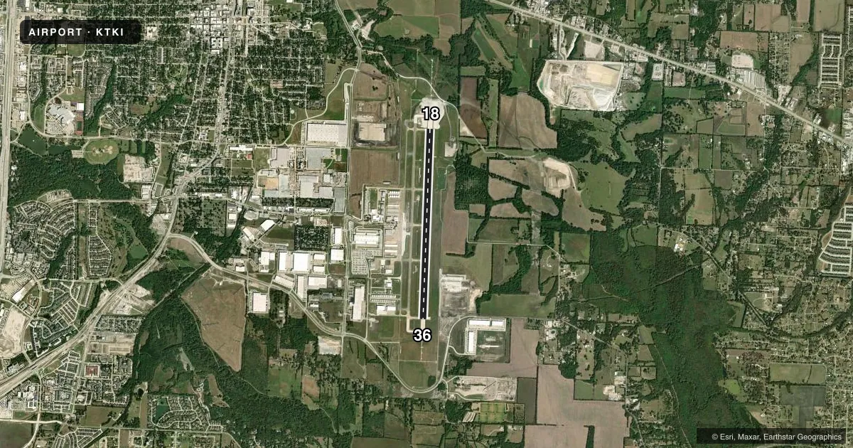
Airport sketch
Runways drawn to scale from FAA survey coordinates, rendered over satellite imagery. Not for navigation.
Approaches & charts
ILS · 1
Services on the field
Fuel grades, oxygen, maintenance, ramp storage and lighting — as declared to the FAA by the airport operator.
Fuel & services
- Fuel
- 100LLA1+
- Oxygen (bottled)
- High pressure
- Airframe repair
- Major
- Power plant repair
- Major
- Other services
- AMB,CHTR,INSTR
Ramp & ground
- Transient storage
- Tie-down
- Hangar
- Landing fee
- No fee published
- Customs
- Not available
- Lighting schedule
- SEE RMK
- Beacon schedule
- SS-SR
- Beacon
- White / Green (civil land)(WG)
- Wind indicator
- Lighted
- Segmented circle
- Yes
Fuel & FBOs
Cheapest 100LL and Jet A on the field and nearby. Always confirm with the FBO before taxi.
Airport notes
Surface conditions, obstructions, local procedures, lighting outages and other notes published with each FAA cycle.
General notes
- BIRD ACTIVITY INVOF ARPT.
- ARPT ADMIN. 972-562-4053
- NO TGLS BTWN 0600-0700 AND 2100-2200.
- NOISE SENSITIVE AREAS S OF ARPT. PILOTS ARE REQD TO USE NBAA STD NOISE PROCS. RWY 18 DEP VFR ACFT REQ DEP TURN HDG 135 DEGS WITH ATC APVL.
Lighting notes
- WHEN ATCT CLSD ACTVT MALSR RWY 18; PAPI RWY 18 & 36; HIRL RWY 18/36 - CTAF. MALS RWY 36 OPR CONSLY.
Runway surface & condition
- 18/36ACTUAL RWY LENGTH DOES NOT MATCH PUBLISHED VALUE. 500 FT EXTENSION ON SOUTH END MKD AS DSPLCD THLD.
Other notes
- ARPT OPNSBSQUIRE@FLYTKI.COM
VFR map & nearby airports
VFR sectional. Tap any ICAO chip to open that airport.
Key facts · KTKI
Answer card- ICAO
- KTKI
- Name
- MCKINNEY NTL
- Location
- DALLAS, TEXAS
- Elevation
- 588.9 ft MSL
- Traffic pattern altitude
- 1,588.9 ft MSL (1,000 AGL)
- Control tower
- Towered · 0600-2200
- Total runways
- 1
- Longest runway
- 18/36 · 7,002 ft
- Published ILS approaches
- 1
- Published frequencies
- 8
- Magnetic variation
- 3°
- Current flight rules
- VFR
- Current wind
- 140° at 4 kt
- Favored runway now
- RWY 18
McKinney NTL sits in Dallas, Texas at 588.9 ft MSL. It has one runway, 18/36, with a listed length of 7,002 ft. The field is towered from 0600 to 2200. Runway 18 has an ILS approach. Pattern altitude is not published, so use 1,000 ft AGL for light piston traffic unless ATC or the current FAA Chart Supplement says otherwise.
McKinney Air Center is on the field. It carries 100LL, Jet A and Jet A Prist. Call (972) 547-3401 for current service details. The published remarks matter here. The south side of the airport is noise sensitive. Pilots are expected to follow NBAA standard noise procedures. VFR departures from runway 18 need a turn to heading 135 degrees with ATC approval. There is also bird activity in the area.
A first-time pilot should plan for a busy controlled field with specific noise rules and runway-use details. The published notes also say the actual usable runway length does not match the charted value because of a 500-foot extension on the south end marked by a displaced threshold. Check the current FAA Chart Supplement before you go. If you plan to arrive near the tower opening or closing times, pay close attention to lighting procedures. Also note the no touch-and-go windows from 0600 to 0700 and from 2100 to 2200.