METAR & TAF KGYI
Current METAR
Observed 11:35Z
KGYI 271135Z AUTO 18008KT 9SM CLR 24/20 A2995 RMK AO2 T02390203 $
- Wind
- 180° @ 8 kt
- Visibility
- 9 SM
- Temp / Dew
- 24°C / 20°C
- Altimeter
- 29.95 inHg
- Clouds
- CLR
- Density alt
- 1,972 ft
- Ceiling
- Unlimited
- Rules
- VFR
Airport info & contacts
Manager on record, flight service, ARTCC, attendance schedule and pattern altitude — published by the FAA and refreshed every 28 days.
Location
- From city
- 4 NM W
- VFR sectional
- DALLAS-FT WORTH
- ARTCC
- ZFW · FORT WORTH
- NOTAM facility
- GYI (NOTAM-D)
Airport manager
- Name
- BILL MAGERS
- Phone
- 903-786-2904
- Address
- 4700 AIRPORT DR, DENISON TX 75020
Flight service · Hours
- FSS FTW
- FORT WORTH1-800-WX-BRIEF
- Attendance
- 0700-1900
Frequencies
Tap any row to copy the frequency to your clipboard.
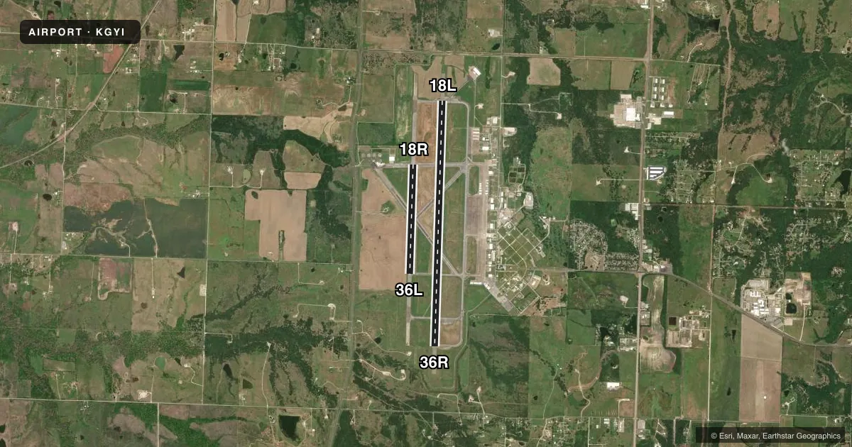
Runways & pattern
Full pagePattern entry · RWY 18L
LEFT TRAFFIC| Runway | Heading (°M) | Length | Surface | Traffic |
|---|---|---|---|---|
| 18L/36RFavored | 179° / 359° | 9,000 ft | ASPH-CONC | Standard L |
| 18R/36L | 179° / 359° | 4,008 ft | ASPH-CONC | Standard L |
Runway end performance
| End | TORA | TODA | ASDA | LDA | VGSI | Approach lights | Obstruction |
|---|---|---|---|---|---|---|---|
| 18L | — | — | — | — | VASI 4-box left(3°) | MALSR | 20', trees, 700' from thr, 400' R of cntrln, slope 25 |
| 36R | — | — | — | — | VASI 4-box left(3°) | MALS | — |
Declared distances in feet. TORA = takeoff run available, TODA = takeoff distance, ASDA = accelerate-stop, LDA = landing distance.
Airport sketch
Runways drawn to scale from FAA survey coordinates, rendered over satellite imagery. Not for navigation.
Approaches & charts
ILS · 1
Services on the field
Fuel grades, oxygen, maintenance, ramp storage and lighting — as declared to the FAA by the airport operator.
Fuel & services
- Fuel
- 100LLA
- Oxygen (bottled)
- High pressure
- Airframe repair
- Major
- Power plant repair
- Major
- Other services
- INSTR
Ramp & ground
- Transient storage
- Tie-down
- Hangar
- Landing fee
- No fee published
- Customs
- Not available
- Lighting schedule
- SEE RMK
- Beacon schedule
- SS-SR
- Beacon
- White / Green (civil land)(WG)
- Wind indicator
- Lighted
- Segmented circle
- Yes
Fuel & FBOs
Cheapest 100LL and Jet A on the field and nearby. Always confirm with the FBO before taxi.
Airport notes
Surface conditions, obstructions, local procedures, lighting outages and other notes published with each FAA cycle.
General notes
- RWY 18L DSGND CALM WIND RWY.
- TXY MKGS & HOLD LINES FADED.
- FOR CD IF UNA TO CTC ON FSS FREQ, CTC FORT WORTH ARTCC AT 817-858-7584.
Lighting notes
- DUSK-DAWN. MIRL RWY 18L/36R PRESET LOW INTST; TO INCR INTST & ACTVT MALSR RWY 18L & MALS RWY 36R - CTAF.
Fuel notes
- 100LL100LL SELF SERVE. FOR FUEL AFT HRS CALL 903-786-2666; CALL-IN FEE.
Other notes
- 18R/36LEXTENSIVE SFC CRACKING.
VFR map & nearby airports
VFR sectional. Tap any ICAO chip to open that airport.
Key facts · KGYI
Answer card- ICAO
- KGYI
- Name
- NORTH TEXAS RGNL/PERRIN FLD
- Location
- SHERMAN/DENISON, TEXAS
- Elevation
- 749.3 ft MSL
- Traffic pattern altitude
- 1,749.3 ft MSL (1,000 AGL)
- Control tower
- Towered · 0700-1900
- Total runways
- 2
- Longest runway
- 18L/36R · 9,000 ft
- Published ILS approaches
- 1
- Published frequencies
- 5
- Magnetic variation
- 3°
- Current flight rules
- VFR
- Current wind
- 180° at 8 kt
- Favored runway now
- RWY 18L
North Texas Rgnl/Perrin Fld sits in Sherman/Denison, Texas. Field elevation is 749.3 ft MSL. The airport has two runways. The longest is 18L/36R at 9,000 ft. The other runway is 18R/36L at 4,008 ft. The tower is open 0700-1900. Outside those hours, use CTAF and be ready for non-towered procedures.
KGYI has one ILS approach. It is to runway 18L. Runway headings are magnetic. The published pattern altitude is not listed in the facts. Use the standard 1,000 ft AGL pattern for light piston traffic unless the current Chart Supplement says otherwise. Rise Aviation is on the field. It carries 100LL, Jet A and Jet A Prist. Self-serve 100LL is published. After-hours fuel is available by phone. A call-in fee applies.
A few operational notes matter here. Runway 18L is the calm wind runway. Medium intensity runway lights on 18L/36R start at low intensity from dusk to dawn. Use CTAF to increase intensity. Use CTAF to activate the approach lighting system with runway alignment indicators on 18L. Use CTAF to activate the medium intensity approach lighting system on 36R. Taxiway markings and hold lines are faded. Runway 18R/36L has extensive surface cracking. If you need clearance delivery and cannot reach flight service, contact Fort Worth ARTCC. This is a field where a careful taxi and a current briefing pay off.