METAR & TAF F99
F99 does not publish a METAR.
Showing the nearest reporting station: KSRE (SEMINOLE MUNI) · 17.0 NM away. Conditions at F99 may differ.
METAR · KSRE
Observed 13:35Z
KSRE 271335Z AUTO VRB04KT 10SM CLR 27/20 A2994 RMK AO2
- Wind
- VAR @ 4 kt
- Visibility
- 10 SM
- Temp / Dew
- 27°C / 20°C
- Altimeter
- 29.94 inHg
- Clouds
- CLR
- Density alt
- 2,483 ft
- Ceiling
- Unlimited
- Rules
- VFR
Airport info & contacts
Manager on record, flight service, ARTCC, attendance schedule and pattern altitude — published by the FAA and refreshed every 28 days.
Location
- From city
- 1 NM NW
- VFR sectional
- DALLAS-FT WORTH
- ARTCC
- ZFW · FORT WORTH
- NOTAM facility
- MLC (NOTAM-D)
Airport manager
- Name
- ARTHUR COOK
- Phone
- 254-368-4635
- Address
- PO BOX 789, 100 N. CREEK, 100 N. CREEK, HOLDENVILLE OK 74848
Flight service · Hours
- FSS MLC
- MC ALESTER1-800-WX-BRIEF
- Attendance
- UNATTND
Frequencies
Tap any row to copy the frequency to your clipboard.
Runways & pattern
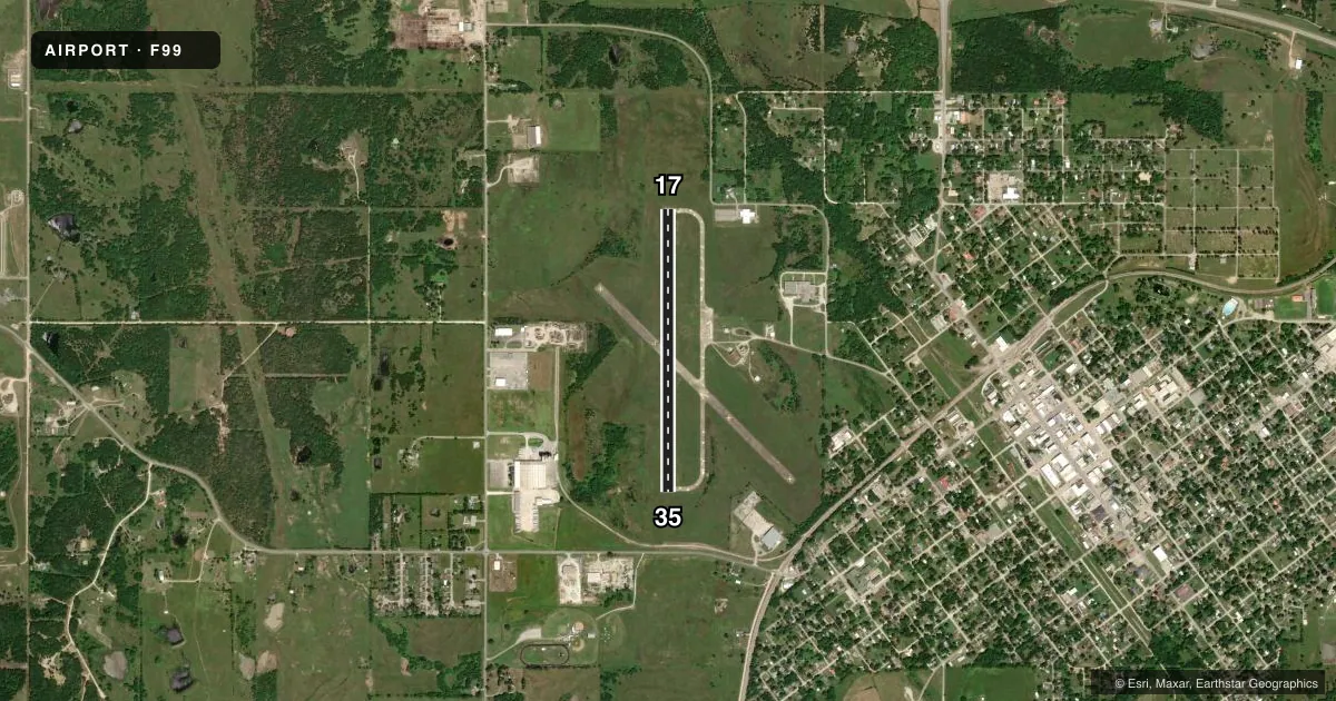
Full pagePattern entry · RWY 35
LEFT TRAFFICAirport sketch
Runways drawn to scale from FAA survey coordinates, rendered over satellite imagery. Not for navigation.
Approaches & charts
Services on the field
Fuel grades, oxygen, maintenance, ramp storage and lighting — as declared to the FAA by the airport operator.
Fuel & services
- Fuel
- Not available
- Oxygen (bottled)
- Not available
- Oxygen (bulk)
- Not available
- Airframe repair
- Not available
- Power plant repair
- Not available
- Other services
- AGRI,INSTR
Ramp & ground
- Transient storage
- Tie-down
- Landing fee
- No fee published
- Customs
- Not available
- Lighting schedule
- SS-SR
- Beacon schedule
- SS-SR
- Beacon
- White / Green (civil land)(WG)
- Wind indicator
- Lighted
- Segmented circle
- Yes
Fuel & FBOs
Cheapest 100LL and Jet A on the field and nearby. Always confirm with the FBO before taxi.
Airport notes
Surface conditions, obstructions, local procedures, lighting outages and other notes published with each FAA cycle.
General notes
- 125 FT AGL SILO .3 NM W RY 35 THLD.
- FOR CD CTC FORT WORTH ARTCC AT 817-858-7584.
Runway surface & condition
- 17/35LGTS NSTD DIST FM RWY EDGE.
Other notes
- THIS AIRPORT HAS BEEN SURVEYED BY THE NATIONAL GEODETIC SURVEY.
- ESTB.PRIOR TO 1959.
VFR map & nearby airports
VFR sectional. Tap any ICAO chip to open that airport.
Key facts · F99
Answer card- ICAO
- F99
- Name
- HOLDENVILLE MUNI
- Location
- HOLDENVILLE, OKLAHOMA
- Elevation
- 860.9 ft MSL
- Traffic pattern altitude
- 1,860.9 ft MSL (1,000 AGL)
- Control tower
- Non-towered (use CTAF)
- Total runways
- 1
- Longest runway
- 17/35 · 3,251 ft
- Published ILS approaches
- 0
- Published frequencies
- 1
- Magnetic variation
- 6°
- Current flight rules
- VFR
- Current wind
- 000° at 4 kt
- Favored runway now
- RWY 35
Holdenville Muni sits in Holdenville, Oklahoma. Field elevation is 860.9 ft MSL. The airport has one runway, 17/35, which is 3,251 ft long and surfaced in concrete. There is no control tower. CTAF is 122.9. No ILS approaches are published here.
Pattern altitude is not published. Use the standard 1,000 ft AGL pattern unless the current Chart Supplement says otherwise. That puts the light piston pattern at about 1,860.9 ft MSL based on the field elevation. Runway 17/35 lighting is noted as not being the standard distance from the runway edge. Plan to verify the lighting setup before a night arrival.
A 125 ft AGL silo sits 0.3 NM west of the runway 35 threshold. That is the main local obstacle called out in the remarks. Clearance delivery is handled through Fort Worth ARTCC at 817-858-7584. There are no on-field FBOs listed in the facts, so call the airport operator directly or use CTAF for current service details before you go. This is a non-towered field, so expect self-announce traffic and keep a close scan on final and the pattern.