METAR & TAF O47
O47 does not publish a METAR.
Showing the nearest reporting station: KSRE (SEMINOLE MUNI) · 12.6 NM away. Conditions at O47 may differ.
METAR · KSRE
Observed 16:35Z
KSRE 271635Z AUTO VRB06G12KT 10SM CLR 34/19 A2992 RMK AO2
- Wind
- VAR @ 6G12 kt
- Visibility
- 10 SM
- Temp / Dew
- 34°C / 19°C
- Altimeter
- 29.92 inHg
- Clouds
- CLR
- Density alt
- 3,571 ft
- Ceiling
- Unlimited
- Rules
- VFR
Airport info & contacts
Manager on record, flight service, ARTCC, attendance schedule and pattern altitude — published by the FAA and refreshed every 28 days.
Location
- From city
- 2 NM W
- VFR sectional
- DALLAS-FT WORTH
- ARTCC
- ZFW · FORT WORTH
- NOTAM facility
- MLC (NOTAM-D)
Airport manager
- Name
- JIM GREFF
- Phone
- 405-567-2270
- Address
- 508 AIRPORT RD, PRAGUE OK 74864
Flight service · Hours
- FSS MLC
- MC ALESTER1-800-WX-BRIEF
- Attendance
- Unattended
Frequencies
Tap any row to copy the frequency to your clipboard.
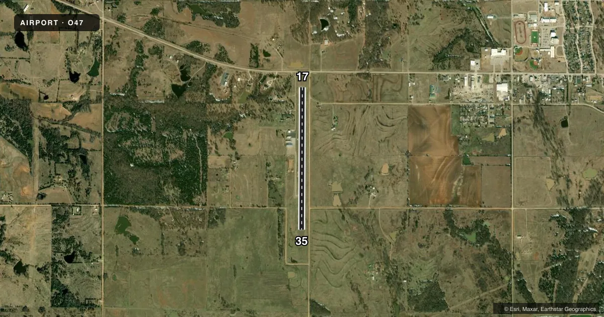
Runways & pattern
Full pagePattern entry · RWY 35
LEFT TRAFFICRunway end performance
| End | TORA | TODA | ASDA | LDA | VGSI | Approach lights | Obstruction |
|---|---|---|---|---|---|---|---|
| 17 | — | — | — | — | PAPI 2-box left(3°) | — | 48', tree, 245' from thr, 221' R of cntrln, slope 0 |
| 35 | — | — | — | — | PAPI 2-box left(3°) | — | — |
Declared distances in feet. TORA = takeoff run available, TODA = takeoff distance, ASDA = accelerate-stop, LDA = landing distance.
Airport sketch
Runways drawn to scale from FAA survey coordinates, rendered over satellite imagery. Not for navigation.
Approaches & charts
Services on the field
Fuel grades, oxygen, maintenance, ramp storage and lighting — as declared to the FAA by the airport operator.
Fuel & services
- Fuel
- 100LL
- Oxygen (bottled)
- Not available
- Oxygen (bulk)
- Not available
- Airframe repair
- Major
- Power plant repair
- Major
- Other services
- INSTR
Ramp & ground
- Transient storage
- Tie-down
- Landing fee
- No fee published
- Customs
- Not available
- Lighting schedule
- SEE RMK
- Beacon schedule
- SS-SR
- Beacon
- White / Green (civil land)(WG)
- Wind indicator
- Lighted
- Segmented circle
- Yes
Fuel & FBOs
Cheapest 100LL and Jet A on the field and nearby. Always confirm with the FBO before taxi.
Airport notes
Surface conditions, obstructions, local procedures, lighting outages and other notes published with each FAA cycle.
General notes
- FOR CD CTC FORT WORTH ARTCC AT 817-858-7584.
Lighting notes
- MIRL RWY 17/35 ON SS-SR, PRESET LOW INTST. INCR INTST - CTAF.
Fuel notes
- 100LLAVBL 24 HRS CREDIT CARD ADPS.
Approach & departure obstructions
- 1736 FT PWR LN 225 FT LEFT OF RWY CNTRLN. 15 FT ROAD AT RWY END, 185 FT LEFT AND 150 FT RIGHT OF CNTRLN.
- 3536 FT PWR LN 225 FT LEFT OF RWY CNTRLN. 15 FT ROAD AT RWY END, 185 FT RIGHT OF CNTRLN.
- 17CTLG OBSTN EXCEEDS A 45 DEGREE SLOPE DTHR CREATES 8:1 CLNC SLOPE TO RWY THR.
Other notes
- FREQ OTS INDEFLY.
- MANAGERCITY MGR.
- 17/35LARGE LONG AND TRANSVERSE CRACKS IN RWY SFC.
VFR map & nearby airports
VFR sectional. Tap any ICAO chip to open that airport.
Key facts · O47
Answer card- ICAO
- O47
- Name
- PRAGUE MUNI
- Location
- PRAGUE, OKLAHOMA
- Elevation
- 1,041 ft MSL
- Traffic pattern altitude
- 2,041 ft MSL (1,000 AGL)
- Control tower
- Non-towered (use CTAF)
- Total runways
- 1
- Longest runway
- 17/35 · 3,600 ft
- Published ILS approaches
- 0
- Published frequencies
- 1
- Magnetic variation
- 3°
- Current flight rules
- VFR
- Current wind
- 000° at 6 kt
- Favored runway now
- RWY 35
Prague Muni sits in Prague, Oklahoma. Field elevation is 1,041 ft MSL. The airport has one runway. Runway 17/35 is 3,600 ft long and asphalt. There is no control tower. CTAF is 122.9, though the published remarks say the frequency is out of service indefinitely. Check current airport procedures before you go.
No ILS approaches are published here. Pattern altitude is not published, so use the standard 1,000 ft AGL for light piston operations unless the current Chart Supplement says otherwise. The on-field FBO is Prague Municipal Airport. It carries AVGAS 100LL. 24-hour self-serve fuel is available with a credit card pump.
There are a few things to brief before arrival. Medium intensity runway lights on 17/35 run from sunset to sunrise at preset low intensity. Increase intensity on CTAF. There is a 36-foot power line left of the runway centerline. A road also sits near the runway end. Runway 17 has a displaced threshold, so plan for the published threshold environment and the 8 to 1 clearance slope. The city manager is the airport manager. For clearance delivery, contact Fort Worth ARTCC at 817-858-7584. If you are planning a night or first-time arrival, verify the current Chart Supplement and call the airport operator for the latest local picture.