METAR & TAF KSUD
KSUD does not publish a METAR.
Showing the nearest reporting station: KCQB (CHANDLER RGNL) · 8.9 NM away. Conditions at KSUD may differ.
METAR · KCQB
Observed 15:55Z
KCQB 271555Z AUTO 19008KT 10SM CLR 34/21 A2992 RMK AO2 T03360205
- Wind
- 190° @ 8 kt
- Visibility
- 10 SM
- Temp / Dew
- 34°C / 21°C
- Altimeter
- 29.92 inHg
- Clouds
- CLR
- Density alt
- 3,397 ft
- Ceiling
- Unlimited
- Rules
- VFR
Airport info & contacts
Manager on record, flight service, ARTCC, attendance schedule and pattern altitude — published by the FAA and refreshed every 28 days.
Location
- From city
- 3 NM N
- VFR sectional
- DALLAS-FT WORTH
- ARTCC
- ZKC · KANSAS CITY
- NOTAM facility
- MLC (NOTAM-D)
Airport manager
- Name
- BOB PEARMAN
- Phone
- (918) 290-0787
- Address
- 220 W. 2ND ST., P. O. BOX 500, STROUD OK 74079
Flight service · Hours
- FSS MLC
- MC ALESTER1-800-WX-BRIEF
- Attendance
- Unattended
Frequencies
Tap any row to copy the frequency to your clipboard.
Runways & pattern
Full pagePattern entry · RWY 18
LEFT TRAFFICRunway end performance
| End | TORA | TODA | ASDA | LDA | VGSI | Approach lights | Obstruction |
|---|---|---|---|---|---|---|---|
| 18 | — | — | — | — | PAPI 2-box left | — | — |
| 36 | — | — | — | — | PAPI 2-box left | — | — |
Declared distances in feet. TORA = takeoff run available, TODA = takeoff distance, ASDA = accelerate-stop, LDA = landing distance.
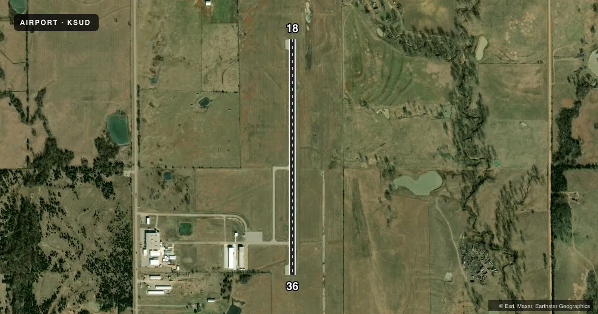
Airport sketch
Runways drawn to scale from FAA survey coordinates, rendered over satellite imagery. Not for navigation.
Approaches & charts
Services on the field
Fuel grades, oxygen, maintenance, ramp storage and lighting — as declared to the FAA by the airport operator.
Fuel & services
- Fuel
- 100LLA
- Oxygen (bottled)
- Not available
- Oxygen (bulk)
- Not available
- Airframe repair
- Major
- Power plant repair
- Major
Ramp & ground
- Transient storage
- Tie-down
- Landing fee
- No fee published
- Customs
- Not available
- Lighting schedule
- SEE RMK
- Beacon schedule
- SS-SR
- Beacon
- White / Green (civil land)(WG)
- Wind indicator
- Lighted
- Segmented circle
- No
Fuel & FBOs
Cheapest 100LL and Jet A on the field and nearby. Always confirm with the FBO before taxi.
Airport notes
Surface conditions, obstructions, local procedures, lighting outages and other notes published with each FAA cycle.
General notes
- 30 FT UNMARKED POWERLINE LOCATED APPROX 990 FT FROM RWY 18 END.
- FOR CD CTC KANSAS CITY ARTCC AT 913-254-8508.
Lighting notes
- ACTVT PAPI RWY 18 & 36; MIRL RWY 18/36 - CTAF.
Fuel notes
- 100LLFUEL AVAILABLE 24 HR WITH CREDIT CARD.
Other notes
- ESTAB PRIOR TO 1959.
- MANAGERCITY MANAGER
VFR map & nearby airports
VFR sectional. Tap any ICAO chip to open that airport.
Key facts · KSUD
Answer card- ICAO
- KSUD
- Name
- STROUD MUNI
- Location
- STROUD, OKLAHOMA
- Elevation
- 900.7 ft MSL
- Traffic pattern altitude
- 1,900.7 ft MSL (1,000 AGL)
- Control tower
- Non-towered (use CTAF)
- Total runways
- 1
- Longest runway
- 18/36 · 3,000 ft
- Published ILS approaches
- 0
- Published frequencies
- 1
- Magnetic variation
- 6°
- Current flight rules
- VFR
- Current wind
- 190° at 8 kt
- Favored runway now
- RWY 18
Stroud Muni is in Stroud, Oklahoma. The field elevation is 900.7 ft MSL. It has one runway, 18/36, which is 3,000 ft long and paved asphalt. The airport is non-towered. CTAF is 122.9.
No ILS approaches are published here. The runway lighting setup includes medium intensity runway lights on 18/36. A precision approach path indicator is also active for both ends. 100LL is available 24 hours with a credit card. There are no on-field FBOs listed in the facts, so verify any service needs before you go.
The published pattern altitude is not listed. Use standard 1,000 ft AGL for light piston traffic unless the current FAA Chart Supplement says otherwise. The airport uses a common traffic advisory frequency. For clearance delivery, contact Kansas City Air Route Traffic Control Center. A 30-foot unmarked powerline sits about 990 feet from the runway 18 end, so keep that in mind on departure and arrival. The airport was established before 1959. The city manager serves as the airport manager. If you are planning a night or low-visibility arrival, check the current Chart Supplement and brief the lighting and runway environment before you launch.