METAR & TAF KCUH
Current METAR
Observed 13:35Z
KCUH 271335Z AUTO 19007KT 10SM CLR 27/18 A2991 RMK AO2 T02730181
- Wind
- 190° @ 7 kt
- Visibility
- 10 SM
- Temp / Dew
- 27°C / 18°C
- Altimeter
- 29.91 inHg
- Clouds
- CLR
- Density alt
- 2,600 ft
- Ceiling
- Unlimited
- Rules
- VFR
Airport info & contacts
Manager on record, flight service, ARTCC, attendance schedule and pattern altitude — published by the FAA and refreshed every 28 days.
Location
- From city
- 2 NM S
- VFR sectional
- DALLAS-FT WORTH
- ARTCC
- ZKC · KANSAS CITY
- NOTAM facility
- CUH (NOTAM-D)
Airport manager
- Name
- MIKE MIDDLETON
- Phone
- 918-225-0881
- Address
- 2414 TOM MALONEY DR, CUSHING OK 74023
Flight service · Hours
- FSS MLC
- MC ALESTER1-800-WX-BRIEF
- Attendance
- MON-FRI · 0800-1700
Frequencies
Tap any row to copy the frequency to your clipboard.
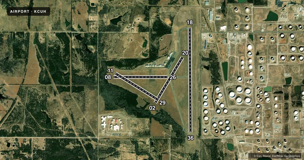
Runways & pattern
Full pagePattern entry · RWY 18
LEFT TRAFFIC| Runway | Heading (°M) | Length | Surface | Traffic |
|---|---|---|---|---|
| 18/36Favored | 175° / 355° | 5,201 ft | CONC | Standard L |
| 08/26 | 85° / 265° | 2,700 ft | TURF | Standard L |
| 02/20 | 26° / 206° | 2,650 ft | TURF | Standard L |
| 11/29 | 117° / 297° | 2,500 ft | TURF | Standard L |
Runway end performance
| End | TORA | TODA | ASDA | LDA | VGSI | Approach lights | Obstruction |
|---|---|---|---|---|---|---|---|
| 18 | 5,201' | 5,201' | 4,986' | 4,986' | PAPI 4-box left(3°) | — | 66', tree, 1168' from thr, 206' R of cntrln, slope 14 |
| 36 | 5,201' | 5,201' | 5,201' | 4,986' | PAPI 4-box left(3°) | — | 44', trees, 1373' from thr, 0' R of cntrln, slope 26 |
| 08 | — | — | — | — | — | — | 41', trees, 409' from thr, 0' R of cntrln, slope 9 |
| 02 | — | — | — | — | — | — | 44', trees, 513' from thr, 0' R of cntrln, slope 11 |
| 11 | — | — | — | — | — | — | 50', trees, 479' from thr, 0' R of cntrln, slope 9 |
Declared distances in feet. TORA = takeoff run available, TODA = takeoff distance, ASDA = accelerate-stop, LDA = landing distance.
Airport sketch
Runways drawn to scale from FAA survey coordinates, rendered over satellite imagery. Not for navigation.
Approaches & charts
Services on the field
Fuel grades, oxygen, maintenance, ramp storage and lighting — as declared to the FAA by the airport operator.
Fuel & services
- Fuel
- 100LLA
- Oxygen (bottled)
- Low pressure
- Oxygen (bulk)
- Low pressure
- Airframe repair
- Major
- Power plant repair
- Major
- Other services
- AMB,PAJA
Ramp & ground
- Transient storage
- Tie-down
- Hangar
- Landing fee
- No fee published
- Customs
- Not available
- Lighting schedule
- SEE RMK
- Beacon schedule
- SS-SR
- Beacon
- White / Green (civil land)(WG)
- Wind indicator
- Lighted
- Segmented circle
- Yes
Fuel & FBOs
Cheapest 100LL and Jet A on the field and nearby. Always confirm with the FBO before taxi.
Airport notes
Surface conditions, obstructions, local procedures, lighting outages and other notes published with each FAA cycle.
General notes
- FOR CD CTC KANSAS CITY ARTCC AT 913-254-8508.
Lighting notes
- ACTVT REIL RWY 18 & 36 - CTAF; PAPI RWY 18 & 36 ON CONSLY; MIRL RWY 18/36 SS-SR PRESET MED INTST; INCR INTST - CTAF.
Fuel notes
- 100LLFUEL AVBL H24 WITH CREDIT CARD.
Other notes
- PRE DATES THE ACT.
- 1UNATNDD FED HOL.
- 02/20TURF RWYS SOFT WHEN WET.
VFR map & nearby airports
VFR sectional. Tap any ICAO chip to open that airport.
Key facts · KCUH
Answer card- ICAO
- KCUH
- Name
- CUSHING MUNI
- Location
- CUSHING, OKLAHOMA
- Elevation
- 925.1 ft MSL
- Traffic pattern altitude
- 1,925.1 ft MSL (1,000 AGL)
- Control tower
- Non-towered (use CTAF)
- Total runways
- 4
- Longest runway
- 18/36 · 5,201 ft
- Published ILS approaches
- 0
- Published frequencies
- 2
- Magnetic variation
- 5°
- Current flight rules
- VFR
- Current wind
- 190° at 7 kt
- Favored runway now
- RWY 18
Cushing Muni sits in Cushing, Oklahoma. The field elevation is 925.1 ft MSL. It has four runways. The longest is runway 18/36 at 5,201 ft of concrete. The airport is non-towered. CTAF and UNICOM are both 122.8.
No ILS approaches are published here. Pattern altitude is not published, so use the standard 1,000 ft AGL for light piston traffic unless the current Chart Supplement says otherwise. Runways 18 and 36 have REIL on the CTAF. PAPI on 18 and 36 runs continuously. Medium intensity lighting on 18/36 is preset from sunset to sunrise. Higher intensity is available on the CTAF.
Cushing Municipal Airport is the on-field FBO. It carries 100LL and Jet A Prist. Fuel is available 24 hours a day with a credit card. Runways 08/26 and 11/29 are soft when wet. The airport is unattended on federal holidays. For clearance delivery, contact Kansas City ARTCC at 913-254-8508. If you are planning a first stop here, watch the turf runways after rain. Also plan for a non-towered arrival and use the published CTAF for traffic calls.