METAR & TAF H97
H97 does not publish a METAR.
Showing the nearest reporting station: KSWO (STILLWATER RGNL) · 18.8 NM away. Conditions at H97 may differ.
METAR · KSWO
Observed 12:53Z
KSWO 271253Z 18006KT 10SM CLR 27/18 A2990 RMK AO2 SLP109 T02720183
- Wind
- 180° @ 6 kt
- Visibility
- 10 SM
- Temp / Dew
- 27°C / 18°C
- Altimeter
- 29.90 inHg
- Clouds
- CLR
- Density alt
- 2,550 ft
- Ceiling
- Unlimited
- Rules
- VFR
Airport info & contacts
Manager on record, flight service, ARTCC, attendance schedule and pattern altitude — published by the FAA and refreshed every 28 days.
Location
- From city
- 2 NM N
- VFR sectional
- KANSAS CITY
- ARTCC
- ZKC · KANSAS CITY
- NOTAM facility
- MLC (NOTAM-D)
Airport manager
- Name
- ALICE COTTLE
- Phone
- 918-762-2658
- Address
- CITY HALL, 510 ILLINOIS ST, PAWNEE OK 74058
Flight service · Hours
- FSS MLC
- MC ALESTER1-800-WX-BRIEF
- Attendance
- Unattended
Frequencies
Tap any row to copy the frequency to your clipboard.
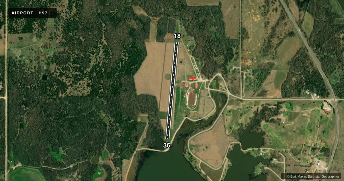
Runways & pattern
Full pagePattern entry · RWY 18
LEFT TRAFFICRunway end performance
| End | TORA | TODA | ASDA | LDA | VGSI | Approach lights | Obstruction |
|---|---|---|---|---|---|---|---|
| 18 | — | — | — | — | — | — | 41', trees, 161' from thr, 65' R of cntrln, slope 3 |
| 36 | — | — | — | — | — | — | 41', trees, 0' from thr, 70' R of cntrln, slope 0 |
Declared distances in feet. TORA = takeoff run available, TODA = takeoff distance, ASDA = accelerate-stop, LDA = landing distance.
Airport sketch
Runways drawn to scale from FAA survey coordinates, rendered over satellite imagery. Not for navigation.
Approaches & charts
Services on the field
Fuel grades, oxygen, maintenance, ramp storage and lighting — as declared to the FAA by the airport operator.
Fuel & services
- Fuel
- Not available
- Oxygen (bottled)
- Not available
- Oxygen (bulk)
- Not available
- Airframe repair
- Not available
- Power plant repair
- Not available
Ramp & ground
- Transient storage
- Tie-down
- Landing fee
- No fee published
- Wind indicator
- Yes
- Segmented circle
- Yes
Fuel & FBOs
Cheapest 100LL and Jet A on the field and nearby. Always confirm with the FBO before taxi.
Airport notes
Surface conditions, obstructions, local procedures, lighting outages and other notes published with each FAA cycle.
General notes
- FOR CD CTC KANSAS CITY ARTCC AT 913-254-8508.
Runway surface & condition
- 18/36SOUTH 300 FT MUDDY AND SOFT WHEN WET.
Approach & departure obstructions
- 1841 FT TREE RWY 18 DER 75 FT LEFT OF CNTRLN.
Other notes
- 1FOR ARPT ATTENDANT CALL POLICE DEPT 918-762-3166.
- MANAGERMAYOR.
VFR map & nearby airports
VFR sectional. Tap any ICAO chip to open that airport.
Key facts · H97
Answer card- ICAO
- H97
- Name
- PAWNEE MUNI
- Location
- PAWNEE, OKLAHOMA
- Elevation
- 875 ft MSL
- Traffic pattern altitude
- 1,875 ft MSL (1,000 AGL)
- Control tower
- Non-towered (use CTAF)
- Total runways
- 1
- Longest runway
- 18/36 · 2,133 ft
- Published ILS approaches
- 0
- Published frequencies
- 1
- Magnetic variation
- 6°
- Current flight rules
- VFR
- Current wind
- 180° at 6 kt
- Favored runway now
- RWY 18
Pawnee Muni is in Pawnee, Oklahoma. The field elevation is 875 ft MSL. It has one runway, 18/36, which is 2,133 ft of turf. The airport is non-towered. CTAF is 122.9.
No ILS approaches are published here. The pattern altitude is not published in the facts, so use the standard 1,000 ft AGL for light piston operations unless the current Chart Supplement says otherwise. That puts the pattern at 1,875 ft MSL based on the field elevation. Verify before you fly. The published remarks matter here. The south 300 ft of runway 18/36 can get muddy and soft when wet. There is also a 41 ft tree 75 ft left of centerline near the departure end for runway 18.
There are no on-field FBOs listed. For airport attendant help, call the police department. For clearance delivery, contact Kansas City Air Route Traffic Control Center. The airport manager is the mayor. Pilots should plan for turf performance, wet-field braking and the obstacle near runway 18. Check the current Chart Supplement and call the airport operator if you need current field condition or operating details.