METAR & TAF KPNC
Current METAR
Observed 15:53Z
KPNC 271553Z AUTO 21008KT 10SM CLR 34/20 A2987 RMK AO2 SLP099 T03440200
- Wind
- 210° @ 8 kt
- Visibility
- 10 SM
- Temp / Dew
- 34°C / 20°C
- Altimeter
- 29.87 inHg
- Clouds
- CLR
- Density alt
- 3,593 ft
- Ceiling
- Unlimited
- Rules
- VFR
Airport info & contacts
Manager on record, flight service, ARTCC, attendance schedule and pattern altitude — published by the FAA and refreshed every 28 days.
Location
- From city
- 2 NM NW
- VFR sectional
- WICHITA
- ARTCC
- ZKC · KANSAS CITY
- NOTAM facility
- PNC (NOTAM-D)
Airport manager
- Name
- DON NUZUM
- Phone
- 580-767-0470
- Address
- BOX 1450, PONCA CITY OK 74602
Flight service · Hours
- FSS MLC
- MC ALESTER1-800-WX-BRIEF
- Attendance
- 0700-1900
Frequencies
Tap any row to copy the frequency to your clipboard.
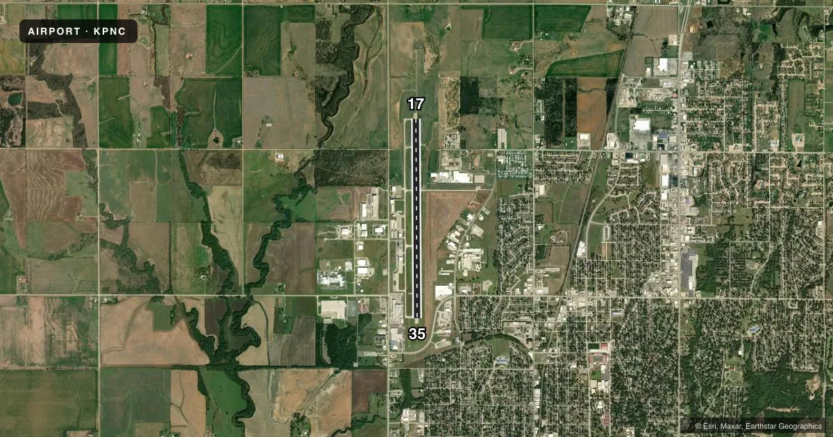
Runways & pattern
Full pagePattern entry · RWY 17
RIGHT TRAFFICRunway end performance
| End | TORA | TODA | ASDA | LDA | VGSI | Approach lights | Obstruction |
|---|---|---|---|---|---|---|---|
| 17 | — | — | — | — | PAPI 4-box left(3°) | MALSR | — |
| 35 | — | — | — | — | PAPI 4-box left(3°) | ODALS | 28', bldg, 710' from thr, 555' R of cntrln, slope 18 |
Declared distances in feet. TORA = takeoff run available, TODA = takeoff distance, ASDA = accelerate-stop, LDA = landing distance.
Airport sketch
Runways drawn to scale from FAA survey coordinates, rendered over satellite imagery. Not for navigation.
Approaches & charts
ILS · 1
Services on the field
Fuel grades, oxygen, maintenance, ramp storage and lighting — as declared to the FAA by the airport operator.
Fuel & services
- Fuel
- 100LLA+
- Oxygen (bottled)
- Not available
- Oxygen (bulk)
- Not available
- Airframe repair
- Major
- Power plant repair
- Major
- Other services
- AMB,CHTR,INSTR,RNTL,SALES
Ramp & ground
- Transient storage
- Tie-down
- Hangar
- Landing fee
- No fee published
- Customs
- Not available
- Lighting schedule
- SEE RMK
- Beacon schedule
- SS-SR
- Beacon
- White / Green (civil land)(WG)
- Wind indicator
- Lighted
- Segmented circle
- Yes
Fuel & FBOs
Cheapest 100LL and Jet A on the field and nearby. Always confirm with the FBO before taxi.
Airport notes
Surface conditions, obstructions, local procedures, lighting outages and other notes published with each FAA cycle.
General notes
- ULTRALIGHTS ON & INVOF ARPT.
- FOR CD IF UNA TO CTC ON FSS FREQ, CTC KANSAS CITY ARTCC AT 913-254-8508.
Lighting notes
- ACTVT MALSR RWY 17; ODALS RWY 35; HIRL RWY 17/35 - CTAF. PAPI RWY 17 & 35 ON CONSLY.
Fuel notes
- 100LL100LL AVBL 24 HRS; SVC AVBL 0700-DUSK; OTR TIMES - 580-767-0429.
Runway surface & condition
- 17/35NORTH 2400 FT NSTD PLASTIC GROOVING ENTIRE WIDTH; 25 FT EACH EDGE REMAINING 4801 FT.
Approach & departure obstructions
- 35PAPI UNUSBL BYD 8 DEGS RIGHT OF CNTRLN.
Other notes
- ESTABLISHED PRIOR TO 1958.
VFR map & nearby airports
VFR sectional. Tap any ICAO chip to open that airport.
Key facts · KPNC
Answer card- ICAO
- KPNC
- Name
- PONCA CITY RGNL
- Location
- PONCA CITY, OKLAHOMA
- Elevation
- 1,008.6 ft MSL
- Traffic pattern altitude
- 2,008.6 ft MSL (1,000 AGL)
- Control tower
- Non-towered (use CTAF)
- Total runways
- 1
- Longest runway
- 17/35 · 7,201 ft
- Published ILS approaches
- 1
- Published frequencies
- 2
- Magnetic variation
- 5°
- Current flight rules
- VFR
- Current wind
- 210° at 8 kt
- Favored runway now
- RWY 17
Ponca City Rgnl is in Ponca City, Oklahoma. Field elevation is 1,008.6 ft MSL. The airport has one runway, 17/35 and it is 7,201 ft long. There is no control tower. CTAF and UNICOM are both 123.0. The published ILS approach is for runway 17.
Pattern altitude is not published. Use the standard 1,000 ft AGL unless the current Chart Supplement says otherwise. That puts the light aircraft pattern at about 2,008.6 ft MSL based on the field elevation. Fuel PNC is on the field. It carries 100LL and Jet A Prist. 100LL is available 24 hours. Service is available from 0700 to dusk. Call the FBO if you need fuel outside those hours.
This field has a few details worth brief attention. Ultralights operate on and near the airport. Runway 17 has MALSR lighting. Runway 35 has ODALS lighting. High intensity runway lights are activated on CTAF for both ends. PAPI lights for both runways are on continuously. The north 2,400 ft of runway 17/35 has nonstandard plastic grooving across the full width. The rest of the runway has grooving on the edges. The PAPI on runway 35 is unusable beyond 8 degrees right of centerline. Check the current Chart Supplement for any noise or curfew restrictions before flying in.