METAR & TAF 95F
95F does not publish a METAR.
Showing the nearest reporting station: KOWP (WILLIAM R POGUE MUNI) · 16.4 NM away. Conditions at 95F may differ.
METAR · KOWP
Observed 14:55Z
KOWP 271455Z AUTO 19005KT 10SM CLR 30/21 A2991 RMK AO2
- Wind
- 190° @ 5 kt
- Visibility
- 10 SM
- Temp / Dew
- 30°C / 21°C
- Altimeter
- 29.91 inHg
- Clouds
- CLR
- Density alt
- 3,023 ft
- Ceiling
- Unlimited
- Rules
- VFR
Airport info & contacts
Manager on record, flight service, ARTCC, attendance schedule and pattern altitude — published by the FAA and refreshed every 28 days.
Location
- From city
- 2 NM S
- VFR sectional
- KANSAS CITY
- ARTCC
- ZKC · KANSAS CITY
- NOTAM facility
- MLC (NOTAM-D)
Airport manager
- Name
- MIKE VAUGHAN
- Phone
- 918-358-3506
- Address
- 105 W CADDO ST, CLEVELAND OK 74020
Flight service · Hours
- FSS MLC
- MC ALESTER1-800-WX-BRIEF
- Attendance
- Unattended
Frequencies
Tap any row to copy the frequency to your clipboard.
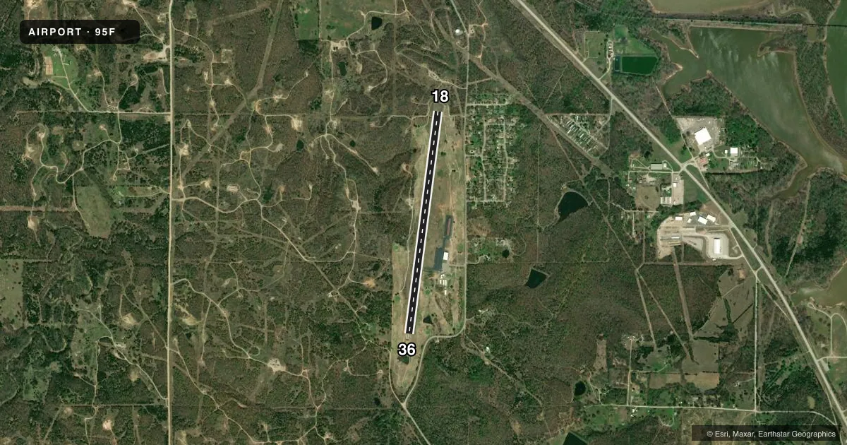
Runways & pattern
Full pagePattern entry · RWY 18
LEFT TRAFFICRunway end performance
| End | TORA | TODA | ASDA | LDA | VGSI | Approach lights | Obstruction |
|---|---|---|---|---|---|---|---|
| 18 | — | — | — | — | PAPI 2-box left(2.75°) | — | 68', pline, 1408' from thr, 245' R of cntrln, slope 17 |
| 36 | — | — | — | — | PAPI 2-box left(2.75°) | — | 40', tree, 860' from thr, 60' R of cntrln, slope 16 |
Declared distances in feet. TORA = takeoff run available, TODA = takeoff distance, ASDA = accelerate-stop, LDA = landing distance.
Airport sketch
Runways drawn to scale from FAA survey coordinates, rendered over satellite imagery. Not for navigation.
Approaches & charts
Services on the field
Fuel grades, oxygen, maintenance, ramp storage and lighting — as declared to the FAA by the airport operator.
Fuel & services
- Fuel
- Not available
- Oxygen (bottled)
- Not available
- Oxygen (bulk)
- Not available
- Airframe repair
- Not available
- Power plant repair
- Not available
Ramp & ground
- Transient storage
- Tie-down
- Hangar
- Landing fee
- No fee published
- Customs
- Not available
- Lighting schedule
- SEE RMK
- Beacon schedule
- SS-SR
- Beacon
- White / Green (civil land)(WG)
- Wind indicator
- Yes
Fuel & FBOs
Cheapest 100LL and Jet A on the field and nearby. Always confirm with the FBO before taxi.
Airport notes
Surface conditions, obstructions, local procedures, lighting outages and other notes published with each FAA cycle.
General notes
- GOLFERS INVOF ARPT.
- FOR CD CTC TULSA APCH AT 918-831-6714/6720.
Lighting notes
- ACTVT MIRL RY 18/36 - CTAF.
Approach & departure obstructions
- 189 FT TREE 67FT FM RWY END 90 FT RIGHT OF EXTDD RWY CNTRLN.
Other notes
- MANAGERCITY MANAGER.
VFR map & nearby airports
VFR sectional. Tap any ICAO chip to open that airport.
Key facts · 95F
Answer card- ICAO
- 95F
- Name
- CLEVELAND MUNI
- Location
- CLEVELAND, OKLAHOMA
- Elevation
- 976 ft MSL
- Traffic pattern altitude
- 1,976 ft MSL (1,000 AGL)
- Control tower
- Non-towered (use CTAF)
- Total runways
- 1
- Longest runway
- 18/36 · 4,000 ft
- Published ILS approaches
- 0
- Published frequencies
- 1
- Magnetic variation
- 6°
- Current flight rules
- VFR
- Current wind
- 190° at 5 kt
- Favored runway now
- RWY 18
Cleveland Muni sits in Cleveland, Oklahoma. Field elevation is 976 ft MSL. The airport has one runway. Runway 18/36 is 4,000 ft long with an asphalt surface. There is no control tower. CTAF is 122.9.
No ILS approaches are published here. The pattern altitude is not published in the facts, so use the standard 1,000 ft AGL for light piston traffic unless the current Chart Supplement says otherwise. Medium intensity runway lights on 18/36 are activated by the CTAF. That matters after dark because you will need to key the mic to bring the lights up.
The published remarks also note a 9-foot tree near the departure end of runway 18. It sits 67 feet from the runway end and 90 feet right of the extended centerline. Plan your departure and landing with that in mind. Golfers are also in the vicinity of the airport, so keep a sharp scan on short final and in the pattern. For clearance delivery, contact Tulsa Approach directly using the numbers in the Chart Supplement. No on-field FBOs are listed, so verify services with the airport operator before you go.