METAR & TAF KOWP
Current METAR
Observed 16:35Z
KOWP 271635Z AUTO 20006KT 10SM CLR 34/22 A2990 RMK AO2
- Wind
- 200° @ 6 kt
- Visibility
- 10 SM
- Temp / Dew
- 34°C / 22°C
- Altimeter
- 29.90 inHg
- Clouds
- CLR
- Density alt
- 3,411 ft
- Ceiling
- Unlimited
- Rules
- VFR
Airport info & contacts
Manager on record, flight service, ARTCC, attendance schedule and pattern altitude — published by the FAA and refreshed every 28 days.
Location
- From city
- 3 NM NW
- VFR sectional
- KANSAS CITY
- ARTCC
- ZKC · KANSAS CITY
- NOTAM facility
- MLC (NOTAM-D)
Airport manager
- Name
- ERICA DECKER
- Phone
- 918-246-2605
- Address
- 3200 N AIRPORT RD, SAND SPRINGS OK 74063
Flight service · Hours
- FSS MLC
- MC ALESTER1-800-WX-BRIEF
- Attendance
- MON-SAT · 0800-1700
- SUN · 1000-1700
Frequencies
Tap any row to copy the frequency to your clipboard.
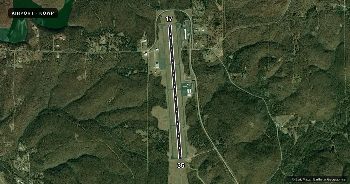
Runways & pattern
Full pagePattern entry · RWY 17
LEFT TRAFFICRunway end performance
| End | TORA | TODA | ASDA | LDA | VGSI | Approach lights | Obstruction |
|---|---|---|---|---|---|---|---|
| 17 | — | — | — | — | PAPI 4-box left(3°) | — | 14', trees, 566' from thr, 264' R of cntrln, slope 26 |
| 35 | — | — | — | — | PAPI 4-box left(3°) | ODALS | — |
Declared distances in feet. TORA = takeoff run available, TODA = takeoff distance, ASDA = accelerate-stop, LDA = landing distance.
Airport sketch
Runways drawn to scale from FAA survey coordinates, rendered over satellite imagery. Not for navigation.
Approaches & charts
Services on the field
Fuel grades, oxygen, maintenance, ramp storage and lighting — as declared to the FAA by the airport operator.
Fuel & services
- Fuel
- 100LL
- Oxygen (bottled)
- Not available
- Oxygen (bulk)
- Not available
- Airframe repair
- Major
- Power plant repair
- Major
- Other services
- INSTR,RNTL
Ramp & ground
- Transient storage
- Tie-down
- Landing fee
- No fee published
- Customs
- Not available
- Lighting schedule
- SEE RMK
- Beacon schedule
- SS-SR
- Beacon
- White / Green (civil land)(WG)
- Wind indicator
- Lighted
- Segmented circle
- Yes
Fuel & FBOs
Cheapest 100LL and Jet A on the field and nearby. Always confirm with the FBO before taxi.
Airport notes
Surface conditions, obstructions, local procedures, lighting outages and other notes published with each FAA cycle.
General notes
- DEER INVOF ARPT.
- FOR CD CTC TULSA APCH AT 918-831-6714/6720.
Lighting notes
- ACTVT ODALS RWY 35; MIRL RWY 17/35 - CTAF. PAPI RWY 17 & 35 ON CONSLY.
Fuel notes
- 100LLFUEL AVBL 24 HRS WITH MAJOR CREDIT CARD.
Approach & departure obstructions
- 17RIGHT TFC FOR HELIS.
- 35PAPI UNUSBL BYD 8 DEGS LEFT, RIGHT OF RCL.
Other notes
- 2ARPT UNATTNDD THANKSGIVING, CHRISTMAS & NEW YEAR'S DAY.
VFR map & nearby airports
VFR sectional. Tap any ICAO chip to open that airport.
Key facts · KOWP
Answer card- ICAO
- KOWP
- Name
- WILLIAM R POGUE MUNI
- Location
- SAND SPRINGS, OKLAHOMA
- Elevation
- 892.2 ft MSL
- Traffic pattern altitude
- 1,892.2 ft MSL (1,000 AGL)
- Control tower
- Non-towered (use CTAF)
- Total runways
- 1
- Longest runway
- 17/35 · 5,799 ft
- Published ILS approaches
- 0
- Published frequencies
- 4
- Magnetic variation
- 2°
- Current flight rules
- VFR
- Current wind
- 200° at 6 kt
- Favored runway now
- RWY 17
William R Pogue Muni sits in Sand Springs, Oklahoma. Field elevation is 892.2 ft MSL. The airport has one runway. Runway 17/35 is 5,799 ft long with asphalt pavement. There is no control tower. CTAF and UNICOM are both 122.7. Tulsa Approach handles clearance delivery and approach control. No ILS approaches are published here. Pattern altitude is not published in the facts, so use the standard 1,000 ft AGL for light piston traffic unless the current FAA Chart Supplement says otherwise.
The on-field FBO is Sand Springs Pogue Airport. It carries 100LL. Fuel is available 24 hours with a major credit card. The field also has runway lighting on 17/35 that is controlled by CTAF. An omnidirectional approach lighting system is active for runway 35. PAPI is available for runways 17 and 35. The published remarks also note deer in the vicinity of the airport. For runway 17, helicopters use right traffic. For clearance delivery, contact Tulsa Approach before departure. This is a good field to brief carefully before arrival because of the lighting setup. The deer hazard is worth planning for. The lack of published ILS support matters for low-weather arrivals.