METAR & TAF 2F6
2F6 does not publish a METAR.
Showing the nearest reporting station: KTUL (TULSA INTL) · 11.1 NM away. Conditions at 2F6 may differ.
METAR · KTUL
Observed 15:53Z
KTUL 271553Z 21006KT 10SM CLR 33/21 A2991 RMK AO2 SLP115 T03330206
- Wind
- 210° @ 6 kt
- Visibility
- 10 SM
- Temp / Dew
- 33°C / 21°C
- Altimeter
- 29.91 inHg
- Clouds
- CLR
- Density alt
- 3,005 ft
- Ceiling
- Unlimited
- Rules
- VFR
Airport info & contacts
Manager on record, flight service, ARTCC, attendance schedule and pattern altitude — published by the FAA and refreshed every 28 days.
Location
- From city
- 1 NM SW
- VFR sectional
- KANSAS CITY
- ARTCC
- ZKC · KANSAS CITY
- NOTAM facility
- MLC (NOTAM-D)
Airport manager
- Name
- BRAD WHITE
- Phone
- 918-396-2797
- Address
- 110 N BROADWAY, PO BOX 399, PO BOX 399, SKIATOOK OK 74070
Flight service · Hours
- FSS MLC
- MC ALESTER1-800-WX-BRIEF
- Attendance
- Unattended
Frequencies
Tap any row to copy the frequency to your clipboard.
Runways & pattern
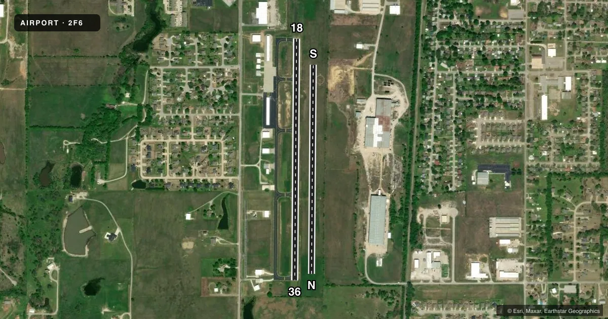
Full pagePattern entry · RWY 18
LEFT TRAFFIC| Runway | Heading (°M) | Length | Surface | Traffic |
|---|---|---|---|---|
| 18/36Favored | 174° / 354° | 3,002 ft | CONC | Standard L |
| N/S | 354° / 174° | 2,600 ft | TURF | Standard L |
Runway end performance
| End | TORA | TODA | ASDA | LDA | VGSI | Approach lights | Obstruction |
|---|---|---|---|---|---|---|---|
| 18 | — | — | — | — | PAPI 2-box left(3°) | — | — |
| 36 | — | — | — | — | — | — | 25', tree, 236' from thr, 77' R of cntrln, slope 1 |
| N | — | — | — | — | — | — | 60', tree, 1690' from thr, 0' R of cntrln, slope 28 |
| S | — | — | — | — | — | — | 25', tree, 390' from thr, 155' R of cntrln, slope 15 |
Declared distances in feet. TORA = takeoff run available, TODA = takeoff distance, ASDA = accelerate-stop, LDA = landing distance.
Airport sketch
Runways drawn to scale from FAA survey coordinates, rendered over satellite imagery. Not for navigation.
Approaches & charts
Services on the field
Fuel grades, oxygen, maintenance, ramp storage and lighting — as declared to the FAA by the airport operator.
Fuel & services
- Fuel
- 100LL
- Oxygen (bottled)
- Not available
- Oxygen (bulk)
- Not available
- Airframe repair
- Not available
- Power plant repair
- Not available
- Other services
- PAJA
Ramp & ground
- Transient storage
- Tie-down
- Hangar
- Landing fee
- No fee published
- Customs
- Not available
- Lighting schedule
- SEE RMK
- Beacon schedule
- SS-SR
- Beacon
- White / Green (civil land)(WG)
- Wind indicator
- Lighted
- Segmented circle
- Yes
Fuel & FBOs
Cheapest 100LL and Jet A on the field and nearby. Always confirm with the FBO before taxi.
Airport notes
Surface conditions, obstructions, local procedures, lighting outages and other notes published with each FAA cycle.
General notes
- FOR CD CTC TULSA APCH AT 918-831-6714/6720.
Lighting notes
- ACTVT MIRL RWY 18/36 - CTAF. PAPI RWY 18 ON CONSLY.
Fuel notes
- 100LLFUEL AVBL 24 HR WITH CREDIT CARD ADP SYS.
Runway surface & condition
- 18/36SPONSOR IMPOSED.
- N/STURF RY CLSD INDEFLY.
Approach & departure obstructions
- 3622 FT TREE 199 FT FM RWY 36 END 115 FT RIGHT OF EXTDD CNTRLN.
- 36PAPI UNUSBL.
- 18RWY 36 20 FT TREE 302 FT FM THLD, 8 FT LEFT; APCH SLOPE TO DTHR 19:1.
VFR map & nearby airports
VFR sectional. Tap any ICAO chip to open that airport.
Key facts · 2F6
Answer card- ICAO
- 2F6
- Name
- SKIATOOK MUNI
- Location
- SKIATOOK, OKLAHOMA
- Elevation
- 671.2 ft MSL
- Traffic pattern altitude
- 1,671.2 ft MSL (1,000 AGL)
- Control tower
- Non-towered (use CTAF)
- Total runways
- 2
- Longest runway
- 18/36 · 3,002 ft
- Published ILS approaches
- 0
- Published frequencies
- 2
- Magnetic variation
- 6°
- Current flight rules
- VFR
- Current wind
- 210° at 6 kt
- Favored runway now
- RWY 18
Skiatook Muni sits in Skiatook, Oklahoma. Field elevation is 671.2 ft MSL. The airport has two runways. The longest usable paved runway is 18/36 at 3,002 ft. The turf north/south runway is closed indefinitely, so plan on the concrete strip for normal operations. There is no control tower. CTAF and UNICOM are both 122.8. No ILS approaches are published here.
Pattern altitude is not published. Use 1,000 ft AGL for light piston work unless the current Chart Supplement says otherwise. That puts the pattern at about 1,671 ft MSL based on the listed field elevation. Runway 18/36 has medium intensity lights that are activated by CTAF. The PAPI on runway 18 is on continuously. The PAPI on runway 36 is unusable. Published remarks also call out a tree near the runway 36 end and another tree near the approach area to runway 36. Pay close attention on short final.
Skiatook Municipal Airport is on field and carries AVGAS 100LL. Fuel is available 24 hours with a credit card automated payment system. Gross weight and single-wheel weight limits are sponsor imposed on runway 18/36. For clearance delivery, contact Tulsa Approach before departure if you need it. First-time pilots should also verify current runway condition, since the turf runway is closed and the paved runway has the listed obstacle notes.