METAR & TAF K11
K11 does not publish a METAR.
Showing the nearest reporting station: KGCM (CLAREMORE RGNL) · 9.5 NM away. Conditions at K11 may differ.
METAR · KGCM
Observed 16:55Z
KGCM 271655Z AUTO 18007KT 10SM CLR 27/15 A2990 RMK AO2
- Wind
- 180° @ 7 kt
- Visibility
- 10 SM
- Temp / Dew
- 27°C / 15°C
- Altimeter
- 29.90 inHg
- Clouds
- CLR
- Density alt
- 2,184 ft
- Ceiling
- Unlimited
- Rules
- VFR
Airport info & contacts
Manager on record, flight service, ARTCC, attendance schedule and pattern altitude — published by the FAA and refreshed every 28 days.
Location
- From city
- 7 NM S
- VFR sectional
- KANSAS CITY
- ARTCC
- ZKC · KANSAS CITY
- NOTAM facility
- MLC (NOTAM-D)
Airport manager
- Name
- RUSTIN POLK
- Phone
- 214-853-5751
- Address
- 10500 E. AIRPARK RD., CLAREMORE OK 74019
Flight service · Hours
- FSS MLC
- MC ALESTER1-800-WX-BRIEF
- Attendance
- Unattended
Frequencies
Tap any row to copy the frequency to your clipboard.
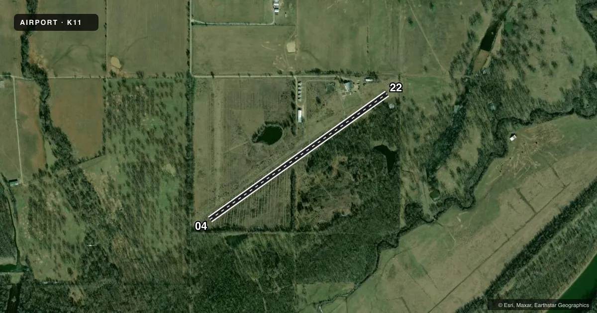
Runways & pattern
Full pagePattern entry · RWY 22
LEFT TRAFFICRunway end performance
| End | TORA | TODA | ASDA | LDA | VGSI | Approach lights | Obstruction |
|---|---|---|---|---|---|---|---|
| 04 | — | — | — | — | — | — | 40', trees, 105' from thr, 0' R of cntrln, slope 2 |
| 22 | — | — | — | — | — | — | 20', trees, 120' from thr, 0' R of cntrln, slope 6 |
Declared distances in feet. TORA = takeoff run available, TODA = takeoff distance, ASDA = accelerate-stop, LDA = landing distance.
Airport sketch
Runways drawn to scale from FAA survey coordinates, rendered over satellite imagery. Not for navigation.
Approaches & charts
Services on the field
Fuel grades, oxygen, maintenance, ramp storage and lighting — as declared to the FAA by the airport operator.
Fuel & services
- Fuel
- Not available
- Oxygen (bottled)
- Not available
- Oxygen (bulk)
- Not available
- Airframe repair
- Not available
- Power plant repair
- Not available
Ramp & ground
- Transient storage
- Not published
- Wind indicator
- No
- Segmented circle
- No
Fuel & FBOs
Cheapest 100LL and Jet A on the field and nearby. Always confirm with the FBO before taxi.
Airport notes
Surface conditions, obstructions, local procedures, lighting outages and other notes published with each FAA cycle.
General notes
- FOR CD CTC TULSA APCH AT 918-831-6714/6720.
Runway surface & condition
- 04/22RY CLSD INDEFLY.
- 18/36RY ENDS UNIDENTIFIABLE.
Other notes
- E111 VFR OPNS ONLY.
- 04/22RUF RWY SFC COVD IN TALL GRASS & WEEDS. TREES & BRUSH ALONG EDGES.
- 18/36RWY COVERED IN TALL GRASS & WEEDS. SURFACE ROUGH. RWY UNIDENTIFIABLE.
VFR map & nearby airports
VFR sectional. Tap any ICAO chip to open that airport.
Key facts · K11
Answer card- ICAO
- K11
- Name
- SAM RIGGS AIRPARK
- Location
- CLAREMORE, OKLAHOMA
- Elevation
- 580 ft MSL
- Traffic pattern altitude
- 1,580 ft MSL (1,000 AGL)
- Control tower
- Non-towered (use CTAF)
- Total runways
- 1
- Longest runway
- 04/22 · 2,760 ft
- Published ILS approaches
- 0
- Published frequencies
- 1
- Magnetic variation
- 6°
- Current flight rules
- VFR
- Current wind
- 180° at 7 kt
- Favored runway now
- RWY 22
Sam Riggs Airpark sits in Claremore, Oklahoma. The field elevation is 580 ft MSL. It has one runway listed, 04/22, at 2,760 ft. The airport is not towered. CTAF is 122.9. No ILS approaches are published.
The published pattern altitude is not listed. Use the standard 1,000 ft AGL pattern unless the current Chart Supplement says otherwise. This field is VFR only. That matters here because the published remarks also say runway 04/22 is closed indefinitely. The same remarks describe the surface as rough, with tall grass and weeds near the runway edges. Trees and brush are also noted along the edges. Runway ends are unidentifiable.
There are no on-field FBOs listed in the facts provided. Plan on confirming services with the airport operator before you go. For clearance delivery, contact Tulsa Approach at 918-831-6714 or 918-831-6720. If you are planning a stop here, verify the current runway status in the FAA Chart Supplement before departure. This is not a field to assume is open from the runway listing alone.