METAR & TAF 4F1
4F1 does not publish a METAR.
Showing the nearest reporting station: KOWP (WILLIAM R POGUE MUNI) · 9.8 NM away. Conditions at 4F1 may differ.
METAR · KOWP
Observed 17:35Z
KOWP 261735Z AUTO 20007KT 10SM CLR 34/23 A2997 RMK AO2
- Wind
- 200° @ 7 kt
- Visibility
- 10 SM
- Temp / Dew
- 34°C / 23°C
- Altimeter
- 29.97 inHg
- Clouds
- CLR
- Density alt
- 3,335 ft
- Ceiling
- Unlimited
- Rules
- VFR
Airport info & contacts
Manager on record, flight service, ARTCC, attendance schedule and pattern altitude — published by the FAA and refreshed every 28 days.
Location
- From city
- 2 NM E
- VFR sectional
- KANSAS CITY
- Pattern altitude
- 600 ft AGL · 1,501 ft MSL
- ARTCC
- ZKC · KANSAS CITY
- NOTAM facility
- MLC (NOTAM-D)
Airport manager
- Name
- ROSS SAUTER
- Phone
- 918-358-6031
- Address
- C/O TOWN OF WESTPORT, 733 ORCHARD LANE, CLEVELAND OK 74020
Flight service · Hours
- FSS MLC
- MC ALESTER1-800-WX-BRIEF
- Attendance
- IREG
Frequencies
Tap any row to copy the frequency to your clipboard.
Runways & pattern
Full pagePattern entry · RWY 21
LEFT TRAFFICRunway end performance
| End | TORA | TODA | ASDA | LDA | VGSI | Approach lights | Obstruction |
|---|---|---|---|---|---|---|---|
| 21 | — | — | — | — | — | — | 19', tree, 224' from thr, 40' R of cntrln, slope 1 |
Declared distances in feet. TORA = takeoff run available, TODA = takeoff distance, ASDA = accelerate-stop, LDA = landing distance.
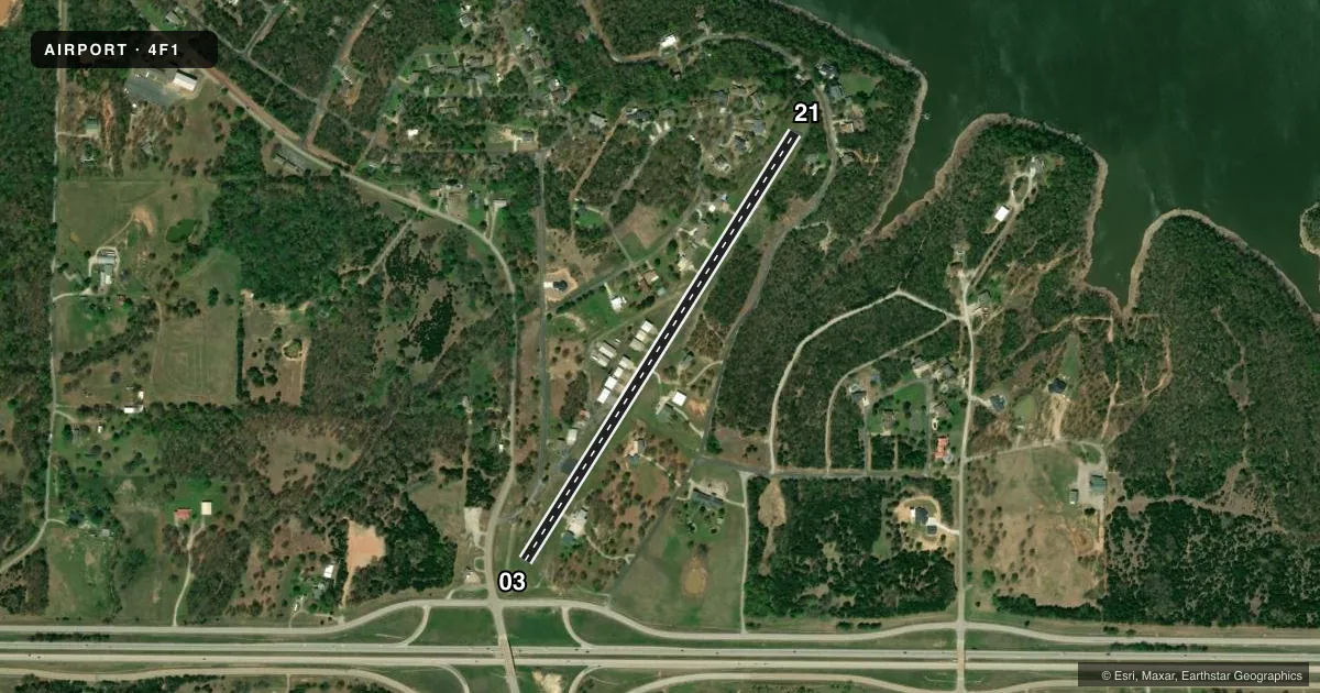
Airport sketch
Runways drawn to scale from FAA survey coordinates, rendered over satellite imagery. Not for navigation.
Approaches & charts
Services on the field
Fuel grades, oxygen, maintenance, ramp storage and lighting — as declared to the FAA by the airport operator.
Fuel & services
- Fuel
- Not available
- Oxygen (bottled)
- Not available
- Oxygen (bulk)
- Not available
- Airframe repair
- Not available
- Power plant repair
- Not available
- Other services
- INSTR
Ramp & ground
- Transient storage
- Not published
- Landing fee
- No fee published
- Lighting schedule
- SEE RMK
- Wind indicator
- No
- Segmented circle
- No
Fuel & FBOs
Cheapest 100LL and Jet A on the field and nearby. Always confirm with the FBO before taxi.
Airport notes
Surface conditions, obstructions, local procedures, lighting outages and other notes published with each FAA cycle.
General notes
- ACTVT RWY LGTS FOR ALL OPS DAY & NIGHT. USE HIGHEST INTST FOR DAYTIME OPS.
- FOR CD CTC TULSA APCH AT 918-831-6714/6720.
Lighting notes
- ACTVT MIRL RY 03/21 - CTAF.
Runway surface & condition
- 03/21LIMITED BY ARPT OPERATOR TO 6000 LBS SINGLE WHEEL GEAR.
- 03/21RY 21 STEEP UPHILL SLOPE UP TO +60 FT HILL AT RY END & 50 FT R OF CENTERLINE.
Approach & departure obstructions
- 217-10 FT TREES 150 FT FM RY END, 58 FT LEFT OF RWY CNTRLN.
Other notes
- VFR ONLY.
- MANAGERBOARD CHAIRMAN.
VFR map & nearby airports
VFR sectional. Tap any ICAO chip to open that airport.
Key facts · 4F1
Answer card- ICAO
- 4F1
- Name
- WESTPORT
- Location
- WESTPORT, OKLAHOMA
- Elevation
- 901 ft MSL
- Traffic pattern altitude
- 1,501 ft MSL (600 AGL)
- Control tower
- Non-towered (use CTAF)
- Total runways
- 1
- Longest runway
- 03/21 · 2,900 ft
- Published ILS approaches
- 0
- Published frequencies
- 1
- Magnetic variation
- 6°
- Current flight rules
- VFR
- Current wind
- 200° at 7 kt
- Favored runway now
- RWY 21
Westport Airport sits in Westport, Oklahoma. Field elevation is 901 ft MSL. The airport has one runway. Runway 03/21 is 2,900 ft of asphalt, so this is a short-field stop rather than a place to plan on extra margin. There is no control tower. CTAF is 122.9. Pattern altitude is 600 ft AGL, which is 1,501 ft MSL.
No ILS approaches are published here. The field is VFR only, so plan with the current chart and weather in hand before you go. Runway lighting is available for day and night use. Use the highest intensity in daytime. The lights on 03/21 are activated by CTAF.
Runway 21 deserves a close look on arrival and departure. The published remarks note a steep uphill slope to a 60-foot hill at the end of the runway. There are also 7 to 10-foot trees near that end, left of centerline. The airport operator also limits the field to 6,000 pounds single wheel gear. No on-field FBOs are listed. For clearance delivery, contact Tulsa Approach at 918-831-6714 or 918-831-6720. If you need current operational details before a flight, verify them with the airport operator or the current FAA Chart Supplement.