METAR & TAF 3OK
3OK does not publish a METAR.
Showing the nearest reporting station: KCQB (CHANDLER RGNL) · 9.7 NM away. Conditions at 3OK may differ.
METAR · KCQB
Observed 12:50Z
KCQB 271250Z AUTO 19006KT 10SM CLR 26/19 A2993 RMK AO2 T02580194
- Wind
- 190° @ 6 kt
- Visibility
- 10 SM
- Temp / Dew
- 26°C / 19°C
- Altimeter
- 29.93 inHg
- Clouds
- CLR
- Density alt
- 2,548 ft
- Ceiling
- Unlimited
- Rules
- VFR
Airport info & contacts
Manager on record, flight service, ARTCC, attendance schedule and pattern altitude — published by the FAA and refreshed every 28 days.
Location
- From city
- 4 NM SE
- VFR sectional
- DALLAS-FT WORTH
- ARTCC
- ZFW · FORT WORTH
- NOTAM facility
- MLC
Airport manager
- Name
- ERIC BIGGS
- Phone
- 405-258-2965
- Address
- 336893 E. 930 RD., WELLSTON OK 74881
Flight service · Hours
- FSS MLC
- MC ALESTER1-800-WX-BRIEF
- Attendance
- MON-SAT · 0800-1700
Frequencies
Tap any row to copy the frequency to your clipboard.
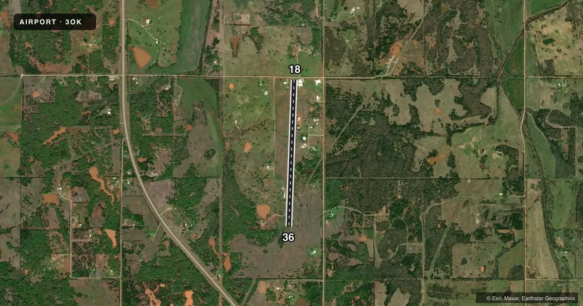
Runways & pattern
Full pagePattern entry · RWY 18
LEFT TRAFFICAirport sketch
Runways drawn to scale from FAA survey coordinates, rendered over satellite imagery. Not for navigation.
Approaches & charts
Services on the field
Fuel grades, oxygen, maintenance, ramp storage and lighting — as declared to the FAA by the airport operator.
Fuel & services
- Fuel
- Not available
- Contract fuel
- Not available
Ramp & ground
- Transient storage
- Not published
- Wind indicator
- Yes
- Segmented circle
- No
Fuel & FBOs
Cheapest 100LL and Jet A on the field and nearby. Always confirm with the FBO before taxi.
Airport notes
Surface conditions, obstructions, local procedures, lighting outages and other notes published with each FAA cycle.
General notes
- FOR CD CTC OKE CITY APCH AT 405-681-5683
Runway surface & condition
- 18/36MAX RWY GWT 6000 LBS.
- 18/36MAX ACFT GWT 6000 LBS.
Other notes
- DAY USE ONLY; PLINES BE OBSTRUCTION MARKED; PROVIDED TRAFFIC PATTERNS FLOWN EAST OF N/S RWY.
VFR map & nearby airports
VFR sectional. Tap any ICAO chip to open that airport.
Key facts · 3OK
Answer card- ICAO
- 3OK
- Name
- BIGGS AIRPORT
- Location
- WELLSTON, OKLAHOMA
- Elevation
- 1,000 ft MSL
- Traffic pattern altitude
- 2,000 ft MSL (1,000 AGL)
- Control tower
- Non-towered (use CTAF)
- Total runways
- 1
- Longest runway
- 18/36 · 3,835 ft
- Published ILS approaches
- 0
- Published frequencies
- 0
- Magnetic variation
- 7°
- Current flight rules
- VFR
- Current wind
- 190° at 6 kt
- Favored runway now
- RWY 18
Biggs Airport sits near Wellston, Oklahoma. Field elevation is 1,000 ft MSL. The airport has one runway. Runway 18/36 is 3,835 ft of turf, which is the longest runway on the field. No control tower is published here. No ILS approaches are published either.
Pattern altitude is not published. Use the standard 1,000 ft AGL for light piston operations unless the current Chart Supplement says otherwise. Published remarks say this is a day use only field. They also note obstruction-marked power lines. Traffic patterns are flown east of the north-south runway. The runway gross weight limit is 6,000 pounds. The same 6,000 pound limit is also listed for aircraft gross weight on 18/36.
There are no on-field FBOs listed in the facts. FBO options vary. Contact the airport operator directly before arrival. Call the field on CTAF/UNICOM for current FBO availability. For clearance delivery, contact Oke City Approach at 405-681-5683. If you are planning a first visit, pay close attention to the turf surface, the day use limitation and the marked power lines near the field.