METAR & TAF KSNL
Current METAR
Observed 06:35Z
KSNL 270635Z AUTO 19007KT 10SM CLR 28/18 A2992 RMK AO2 T02780180 TSNO
- Wind
- 190° @ 7 kt
- Visibility
- 10 SM
- Temp / Dew
- 28°C / 18°C
- Altimeter
- 29.92 inHg
- Clouds
- CLR
- Density alt
- 2,891 ft
- Ceiling
- Unlimited
- Rules
- VFR
Airport info & contacts
Manager on record, flight service, ARTCC, attendance schedule and pattern altitude — published by the FAA and refreshed every 28 days.
Location
- From city
- 2 NM NW
- VFR sectional
- DALLAS-FT WORTH
- ARTCC
- ZFW · FORT WORTH
- NOTAM facility
- SNL (NOTAM-D)
Airport manager
- Name
- BONNIE WILSON
- Phone
- 405-878-1633
- Address
- 2202 AIRPORT DR., SHAWNEE OK 74804
Flight service · Hours
- FSS MLC
- MC ALESTER1-800-WX-BRIEF
- Attendance
- MON-FRI · 0800-1700
Frequencies
Tap any row to copy the frequency to your clipboard.
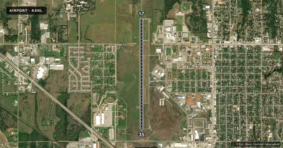
Runways & pattern
Full pagePattern entry · RWY 17
RIGHT TRAFFICRunway end performance
| End | TORA | TODA | ASDA | LDA | VGSI | Approach lights | Obstruction |
|---|---|---|---|---|---|---|---|
| 17 | — | — | — | — | PAPI 4-box left(3°) | MALSR | 22', pline, 1275' from thr, 300' R of cntrln, slope 48 |
| 35 | — | — | — | — | PAPI 4-box left(3°) | — | 37', trees, 1382' from thr, 0' R of cntrln, slope 31 |
Declared distances in feet. TORA = takeoff run available, TODA = takeoff distance, ASDA = accelerate-stop, LDA = landing distance.
Airport sketch
Runways drawn to scale from FAA survey coordinates, rendered over satellite imagery. Not for navigation.
Approaches & charts
ILS · 1
Services on the field
Fuel grades, oxygen, maintenance, ramp storage and lighting — as declared to the FAA by the airport operator.
Fuel & services
- Fuel
- 100LLA+
- Oxygen (bottled)
- Not available
- Oxygen (bulk)
- Not available
- Airframe repair
- Major
- Power plant repair
- Major
- Other services
- AMB,AVNCS,INSTR
Ramp & ground
- Transient storage
- Tie-down
- Hangar
- Landing fee
- No fee published
- Customs
- Not available
- Lighting schedule
- SEE RMK
- Beacon schedule
- SS-SR
- Beacon
- White / Green (civil land)(WG)
- Wind indicator
- Lighted
- Segmented circle
- No
Fuel & FBOs
Cheapest 100LL and Jet A on the field and nearby. Always confirm with the FBO before taxi.
Airport notes
Surface conditions, obstructions, local procedures, lighting outages and other notes published with each FAA cycle.
General notes
- FOR CD CTC OKE APCH AT 405-681-5683.
- PILOTS CONDUCTING EFVS OPS; BE AWARE LED ALS IN USE RWY 17.
Lighting notes
- MIRL RWY 17/35 PRESET LOW INTST; TO INCR INTST & ACTVT MALSR RWY 17 - CTAF.
Fuel notes
- 100LLFUEL AVBL 24 HRS WITH CREDIT CARD.
Approach & departure obstructions
- 17TREE CREATES 48:1 APCH CLC SLP TO DISP THLD.
Other notes
- THIS AIRPORT HAS BEEN SURVEYED BY THE NATIONAL GEODETIC SURVEY.
- 1AFT HRS CALL OUT AVBL - AMGR.
VFR map & nearby airports
VFR sectional. Tap any ICAO chip to open that airport.
Key facts · KSNL
Answer card- ICAO
- KSNL
- Name
- SHAWNEE RGNL
- Location
- SHAWNEE, OKLAHOMA
- Elevation
- 1,073.1 ft MSL
- Traffic pattern altitude
- 2,073.1 ft MSL (1,000 AGL)
- Control tower
- Non-towered (use CTAF)
- Total runways
- 1
- Longest runway
- 17/35 · 5,997 ft
- Published ILS approaches
- 1
- Published frequencies
- 4
- Magnetic variation
- 6°
- Current flight rules
- VFR
- Current wind
- 190° at 7 kt
- Favored runway now
- RWY 17
Shawnee Regional Airport sits in Shawnee, Oklahoma. Field elevation is 1,073.1 ft MSL. The airport has one runway. Runway 17/35 is 5,997 ft long with an asphalt surface. There is no control tower. Pattern altitude is not published, so use the standard 1,000 ft AGL for light piston traffic unless the current Chart Supplement says otherwise.
The field has one ILS approach to runway 17. For clearance delivery, contact Oke Approach at 405-681-5683. CTAF and UNICOM are both 122.7. The on-field FBO is Shawnee Regional Airport. It carries 100LL and Jet A with Prist. Fuel is available 24 hours with credit card. After-hours call-out is available through the airport manager.
There are a few operational items worth having in mind before you go. Runway 17 has medium intensity lights preset to low intensity. Use CTAF to increase intensity and to activate the medium intensity approach lighting system with runway alignment indicator lights for runway 17. An LED approach lighting system is in use on runway 17, so EFVS crews should plan accordingly. A tree creates a 48:1 approach clearance slope to the displaced threshold on runway 17. This is a good airport to brief carefully before arrival, especially if you are new to the field or flying at night.