METAR & TAF KSRE
Current METAR
Observed 14:55Z
KSRE 271455Z AUTO 22007KT 10SM CLR 31/20 A2993 RMK AO2
- Wind
- 220° @ 7 kt
- Visibility
- 10 SM
- Temp / Dew
- 31°C / 20°C
- Altimeter
- 29.93 inHg
- Clouds
- CLR
- Density alt
- 3,176 ft
- Ceiling
- Unlimited
- Rules
- VFR
Airport info & contacts
Manager on record, flight service, ARTCC, attendance schedule and pattern altitude — published by the FAA and refreshed every 28 days.
Location
- From city
- 3 NM N
- VFR sectional
- DALLAS-FT WORTH
- ARTCC
- ZFW · FORT WORTH
- NOTAM facility
- SRE (NOTAM-D)
Airport manager
- Name
- KENNY TAYLOR
- Phone
- 405-382-2180
- Address
- 12021 N HWY 99, SEMINOLE OK 74868
Flight service · Hours
- FSS MLC
- MC ALESTER1-800-WX-BRIEF
- Attendance
- MON-FRI · 0800-1700
- SAT · 0800-1200
Frequencies
Tap any row to copy the frequency to your clipboard.
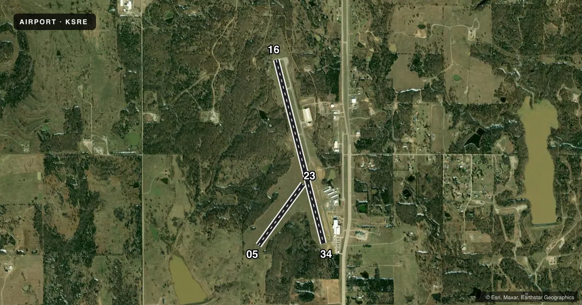
Runways & pattern
Full pagePattern entry · RWY 23
LEFT TRAFFIC| Runway | Heading (°M) | Length | Surface | Traffic |
|---|---|---|---|---|
| 16/34 | 160° / 340° | 5,004 ft | ASPH | Standard L |
| 05/23Favored | 31° / 211° | 2,000 ft | TURF | Standard L |
Runway end performance
| End | TORA | TODA | ASDA | LDA | VGSI | Approach lights | Obstruction |
|---|---|---|---|---|---|---|---|
| 16 | — | — | — | — | PAPI 4-box left(3°) | — | — |
| 34 | — | — | — | — | PAPI 4-box left(3°) | — | — |
Declared distances in feet. TORA = takeoff run available, TODA = takeoff distance, ASDA = accelerate-stop, LDA = landing distance.
Airport sketch
Runways drawn to scale from FAA survey coordinates, rendered over satellite imagery. Not for navigation.
Approaches & charts
Services on the field
Fuel grades, oxygen, maintenance, ramp storage and lighting — as declared to the FAA by the airport operator.
Fuel & services
- Fuel
- 100LLA
- Airframe repair
- Major
- Power plant repair
- Major
- Other services
- AMB,INSTR,SALES
Ramp & ground
- Transient storage
- Tie-down
- Hangar
- Landing fee
- No fee published
- Customs
- Not available
- Lighting schedule
- SEE RMK
- Beacon schedule
- SS-SR
- Beacon
- White / Green (civil land)(WG)
- Wind indicator
- Lighted
- Segmented circle
- Yes
Fuel & FBOs
Cheapest 100LL and Jet A on the field and nearby. Always confirm with the FBO before taxi.
Airport notes
Surface conditions, obstructions, local procedures, lighting outages and other notes published with each FAA cycle.
General notes
- FOR CD CTC FORT WORTH ARTCC AT 817-858-7584.
- DEER AND MISC WILDLIFE ON AND INVOF RWY.
Lighting notes
- MIRL RWY 16/34 PRESET LOW INTST, INCR INTST - CTAF.
Fuel notes
- 100LLSELF SVC AVBL H24.
- ASVC & AFT HR - 405-808-4045.
Other notes
- ESTAB PRIOR TO 1959.
VFR map & nearby airports
VFR sectional. Tap any ICAO chip to open that airport.
Key facts · KSRE
Answer card- ICAO
- KSRE
- Name
- SEMINOLE MUNI
- Location
- SEMINOLE, OKLAHOMA
- Elevation
- 1,023.1 ft MSL
- Traffic pattern altitude
- 2,023.1 ft MSL (1,000 AGL)
- Control tower
- Non-towered (use CTAF)
- Total runways
- 2
- Longest runway
- 16/34 · 5,004 ft
- Published ILS approaches
- 0
- Published frequencies
- 2
- Magnetic variation
- 6°
- Current flight rules
- VFR
- Current wind
- 220° at 7 kt
- Favored runway now
- RWY 23
Seminole Muni sits in Seminole, Oklahoma. The field elevation is 1,023.1 ft MSL. It has two runways. The longest is 16/34 at 5,004 ft. Runway 05/23 is turf and 2,000 ft. There is no control tower. CTAF and UNICOM are both 122.8.
No ILS approaches are published here. Pattern altitude is not published, so use the standard 1,000 ft AGL for light piston operations unless the current Chart Supplement says otherwise. The airport was established before 1959. Self-serve 100LL is available 24 hours a day. Seminole Municipal Airport is the on-field FBO. It carries 100LL and Jet A Prist. Call (405) 382-2180 for the field. Jet A service and after-hours support are listed at (405) 808-4045.
Runway 16/34 has medium intensity lights that are preset low. Pilots need to call up the intensity on CTAF. For clearance delivery, contact Fort Worth ARTCC at 817-858-7584. This is a non-towered field, so keep your traffic calls tight and listen for pattern traffic before joining. The longer asphalt runway is the one most pilots will want for normal arrivals. The turf runway may be useful when conditions favor it. Check surface condition before you commit.