METAR & TAF 3F7
3F7 does not publish a METAR.
Showing the nearest reporting station: KCUH (CUSHING MUNI) · 19.2 NM away. Conditions at 3F7 may differ.
METAR · KCUH
Observed 16:35Z
KCUH 271635Z AUTO 21008KT 10SM CLR 35/18 A2990 RMK AO2 T03510180
- Wind
- 210° @ 8 kt
- Visibility
- 10 SM
- Temp / Dew
- 35°C / 18°C
- Altimeter
- 29.90 inHg
- Clouds
- CLR
- Density alt
- 3,503 ft
- Ceiling
- Unlimited
- Rules
- VFR
Airport info & contacts
Manager on record, flight service, ARTCC, attendance schedule and pattern altitude — published by the FAA and refreshed every 28 days.
Location
- From city
- 3 NM SW
- VFR sectional
- DALLAS-FT WORTH
- ARTCC
- ZKC · KANSAS CITY
- NOTAM facility
- MLC (NOTAM-D)
Airport manager
- Name
- VICKI ROTH
- Phone
- 832-392-9040
- Address
- 24503 S 385TH WEST AVE, BRISTOW OK 74010
Flight service · Hours
- FSS MLC
- MC ALESTER1-800-WX-BRIEF
- Attendance
- Unattended
Frequencies
Tap any row to copy the frequency to your clipboard.
Runways & pattern
Full pagePattern entry · RWY 18
LEFT TRAFFICRunway end performance
| End | TORA | TODA | ASDA | LDA | VGSI | Approach lights | Obstruction |
|---|---|---|---|---|---|---|---|
| 36 | — | — | — | — | — | — | 26', tree, 800' from thr, 230' R of cntrln, slope 23 |
Declared distances in feet. TORA = takeoff run available, TODA = takeoff distance, ASDA = accelerate-stop, LDA = landing distance.
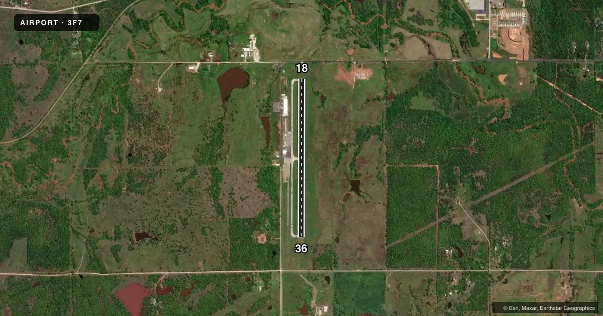
Airport sketch
Runways drawn to scale from FAA survey coordinates, rendered over satellite imagery. Not for navigation.
Approaches & charts
Services on the field
Fuel grades, oxygen, maintenance, ramp storage and lighting — as declared to the FAA by the airport operator.
Fuel & services
- Fuel
- 100LLA+
- Oxygen (bottled)
- Not available
- Oxygen (bulk)
- Not available
Ramp & ground
- Transient storage
- Tie-down
- Landing fee
- No fee published
- Customs
- Not available
- Lighting schedule
- SEE RMK
- Beacon schedule
- SS-SR
- Beacon
- White / Green (civil land)(WG)
- Wind indicator
- Yes
- Segmented circle
- No
Fuel & FBOs
Cheapest 100LL and Jet A on the field and nearby. Always confirm with the FBO before taxi.
Airport notes
Surface conditions, obstructions, local procedures, lighting outages and other notes published with each FAA cycle.
General notes
- FOR CD CTC KANSAS CITY ARTCC AT 913-254-8508.
Lighting notes
- MIRL RWY 18/36 ON DUSK - DAWN. INCR INTST - CTAF.
Fuel notes
- 100LL24 HR. AUTOMATED FUEL SERVICE SYSTEM.
VFR map & nearby airports
VFR sectional. Tap any ICAO chip to open that airport.
Key facts · 3F7
Answer card- ICAO
- 3F7
- Name
- JONES MEML
- Location
- BRISTOW, OKLAHOMA
- Elevation
- 869.6 ft MSL
- Traffic pattern altitude
- 1,869.6 ft MSL (1,000 AGL)
- Control tower
- Non-towered (use CTAF)
- Total runways
- 1
- Longest runway
- 18/36 · 4,001 ft
- Published ILS approaches
- 0
- Published frequencies
- 1
- Magnetic variation
- 5°
- Current flight rules
- VFR
- Current wind
- 210° at 8 kt
- Favored runway now
- RWY 18
Jones Memorial Airport sits in Bristow, Oklahoma. The field elevation is 869.6 ft MSL. It has one runway. Runway 18/36 is 4,001 ft long with asphalt pavement. The airport is not towered. CTAF is 122.9. No ILS approaches are published here.
Pattern altitude is not published. Use the standard 1,000 ft AGL pattern unless current local guidance says otherwise. The field has a magnetic variation of 5°. The on-field FBO is Jones Memorial Airport. It carries 100LL. Twenty-four hour automated fuel service is available for 100LL. Runway lights on 18/36 operate from dusk to dawn. Increased intensity is available on the CTAF.
For a first-time arrival, the main things to plan for are the non-towered traffic flow. Plan for the single runway layout. The lighting setup matters if you are arriving after dark. Clearance delivery is handled through Kansas City ARTCC at 913-254-8508. Check the current FAA Chart Supplement before flight for any updates to procedures or local remarks.