METAR & TAF F81
F81 does not publish a METAR.
Showing the nearest reporting station: KSRE (SEMINOLE MUNI) · 19.7 NM away. Conditions at F81 may differ.
METAR · KSRE
Observed 03:35Z
KSRE 270335Z AUTO 14003KT 10SM CLR 29/19 A2993 RMK AO2
- Wind
- 140° @ 3 kt
- Visibility
- 10 SM
- Temp / Dew
- 29°C / 19°C
- Altimeter
- 29.93 inHg
- Clouds
- CLR
- Density alt
- 2,754 ft
- Ceiling
- Unlimited
- Rules
- VFR
Airport info & contacts
Manager on record, flight service, ARTCC, attendance schedule and pattern altitude — published by the FAA and refreshed every 28 days.
Location
- From city
- 2 NM S
- VFR sectional
- DALLAS-FT WORTH
- ARTCC
- ZFW · FORT WORTH
- NOTAM facility
- MLC (NOTAM-D)
Airport manager
- Name
- KRISTY LESLEY
- Phone
- 918-623-1050
- Address
- 502 W. BROADWAY, OKEMAH OK 74859
Flight service · Hours
- FSS MLC
- MC ALESTER1-800-WX-BRIEF
- Attendance
- Unattended
Frequencies
Tap any row to copy the frequency to your clipboard.
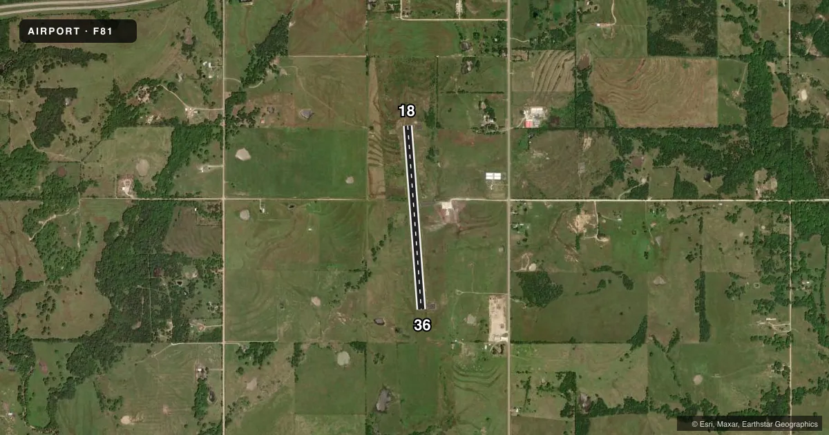
Runways & pattern
Full pagePattern entry · RWY 18
LEFT TRAFFICRunway end performance
| End | TORA | TODA | ASDA | LDA | VGSI | Approach lights | Obstruction |
|---|---|---|---|---|---|---|---|
| 18 | — | — | — | — | — | — | 24', trees, 384' from thr, 0' R of cntrln, slope 7 |
| 36 | — | — | — | — | — | — | 26', tree, 610' from thr, 118' R of cntrln, slope 15 |
Declared distances in feet. TORA = takeoff run available, TODA = takeoff distance, ASDA = accelerate-stop, LDA = landing distance.
Airport sketch
Runways drawn to scale from FAA survey coordinates, rendered over satellite imagery. Not for navigation.
Approaches & charts
Services on the field
Fuel grades, oxygen, maintenance, ramp storage and lighting — as declared to the FAA by the airport operator.
Fuel & services
- Fuel
- Not available
- Oxygen (bottled)
- Not available
- Oxygen (bulk)
- Not available
- Airframe repair
- Not available
- Power plant repair
- Not available
Ramp & ground
- Transient storage
- Tie-down
- Landing fee
- No fee published
- Customs
- Not available
- Lighting schedule
- SEE RMK
- Beacon schedule
- SS-SR
- Beacon
- White / Green (civil land)(WG)
- Wind indicator
- Lighted
- Segmented circle
- No
Fuel & FBOs
Cheapest 100LL and Jet A on the field and nearby. Always confirm with the FBO before taxi.
Airport notes
Surface conditions, obstructions, local procedures, lighting outages and other notes published with each FAA cycle.
General notes
- FOR CD CTC FORT WORTH ARTCC AT 817-858-7584.
Lighting notes
- ACTVT MIRL RWY 18/36 - 122.9
Approach & departure obstructions
- 1813 FT TREE 148 FT FM APCH END RWY 18 104 FT L OF CNTRLN.
- 3612 FT TREE 77 FT FM APCH END RWY 36 134 FT L OF CNTRLN.
Other notes
- ESTAB PRIOR TO 1959.
- MANAGERCITY MANAGER
- MANAGERFOR ASSISTANCE AFT HRS CALL POLICE DEPARTMENT, 918-623-1234.
VFR map & nearby airports
VFR sectional. Tap any ICAO chip to open that airport.
Key facts · F81
Answer card- ICAO
- F81
- Name
- OKEMAH MUNI
- Location
- OKEMAH, OKLAHOMA
- Elevation
- 876.2 ft MSL
- Traffic pattern altitude
- 1,876.2 ft MSL (1,000 AGL)
- Control tower
- Non-towered (use CTAF)
- Total runways
- 1
- Longest runway
- 18/36 · 3,400 ft
- Published ILS approaches
- 0
- Published frequencies
- 1
- Magnetic variation
- 6°
- Current flight rules
- VFR
- Current wind
- 140° at 3 kt
- Favored runway now
- RWY 18
Okemah Muni (F81) sits in Okemah, Oklahoma. Field elevation is 876.2 ft MSL. The airport has one runway. Runway 18/36 is 3,400 ft long with asphalt pavement. There is no control tower, so use CTAF 122.9 for self-announce traffic. No ILS approaches are published here.
Pattern altitude is not published. Use 1,000 ft AGL as the standard light piston pattern unless local procedures or the current Chart Supplement say otherwise. That puts the pattern at about 1,876 ft MSL based on the field elevation. Runway lighting is medium intensity on 18/36. The lights are activated on 122.9.
The published remarks matter here. There is a tree near the approach end of runway 36. There is also a tree near the approach end of runway 18. Clearance delivery is handled through Fort Worth ARTCC at 817-858-7584. For after-hours help, the published contact is the police department. No on-field FBOs are listed, so verify fuel and services with the airport operator or call the field directly before you go. For a first-time arrival, pay attention to the runway-end obstructions. Check the current Chart Supplement for any other local notes before departure.