METAR & TAF F10
F10 does not publish a METAR.
Showing the nearest reporting station: KOKM (OKMULGEE RGNL/PAUL AND BETTY ABBOTT FLD) · 16.0 NM away. Conditions at F10 may differ.
METAR · KOKM
Observed 22:35Z
KOKM 262235Z AUTO 16008KT 10SM CLR 38/22 A2991 RMK AO2 T03780222
- Wind
- 160° @ 8 kt
- Visibility
- 10 SM
- Temp / Dew
- 38°C / 22°C
- Altimeter
- 29.91 inHg
- Clouds
- CLR
- Density alt
- 3,825 ft
- Ceiling
- Unlimited
- Rules
- VFR
Airport info & contacts
Manager on record, flight service, ARTCC, attendance schedule and pattern altitude — published by the FAA and refreshed every 28 days.
Location
- From city
- 3 NM SW
- VFR sectional
- DALLAS-FT WORTH
- ARTCC
- ZFW · FORT WORTH
- NOTAM facility
- MLC (NOTAM-D)
Airport manager
- Name
- DAVID BOLLARD
- Phone
- 918-652-3348
- Address
- PO BOX 608, 10249 LOBLOLLY RD., HENRYETTA OK 74437
Flight service · Hours
- FSS MLC
- MC ALESTER1-800-WX-BRIEF
- Attendance
- Unattended
Frequencies
Tap any row to copy the frequency to your clipboard.
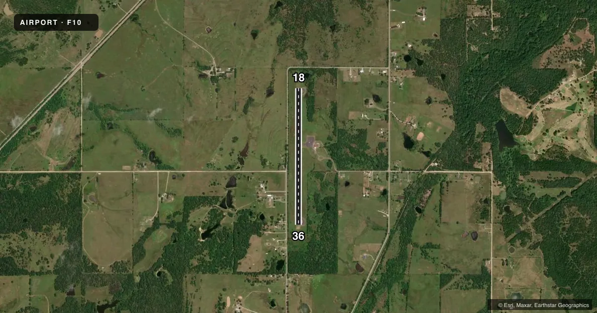
Runways & pattern
Full pagePattern entry · RWY 18
LEFT TRAFFICRunway end performance
| End | TORA | TODA | ASDA | LDA | VGSI | Approach lights | Obstruction |
|---|---|---|---|---|---|---|---|
| 18 | — | — | — | — | PSIL(3.5°) | — | 45', trees, 330' from thr, 140' R of cntrln, slope 2 |
| 36 | — | — | — | — | — | — | 27', trees, 332' from thr, 230' R of cntrln, slope 4 |
Declared distances in feet. TORA = takeoff run available, TODA = takeoff distance, ASDA = accelerate-stop, LDA = landing distance.
Airport sketch
Runways drawn to scale from FAA survey coordinates, rendered over satellite imagery. Not for navigation.
Approaches & charts
Services on the field
Fuel grades, oxygen, maintenance, ramp storage and lighting — as declared to the FAA by the airport operator.
Fuel & services
- Fuel
- Not available
- Oxygen (bottled)
- Not available
- Oxygen (bulk)
- Not available
- Airframe repair
- Not available
- Power plant repair
- Not available
Ramp & ground
- Transient storage
- Tie-down
- Landing fee
- No fee published
- Customs
- Not available
- Lighting schedule
- SEE RMK
- Beacon schedule
- SS-SR
- Beacon
- White / Green (civil land)(WG)
- Wind indicator
- Lighted
- Segmented circle
- Yes
Fuel & FBOs
Cheapest 100LL and Jet A on the field and nearby. Always confirm with the FBO before taxi.
Airport notes
Surface conditions, obstructions, local procedures, lighting outages and other notes published with each FAA cycle.
General notes
- FOR CD CTC FORT WORTH ARTCC AT 817-858-7584.
Lighting notes
- DUSK-DAWN. ACTVT MIRL RY 18/36 - CTAF.
Approach & departure obstructions
- 3626 FT TREE 120 FT FM RWY 36 END 154 FT LEFT OF APCH.
- 18MARKINGS SEVERELY FADED.
- 36MARKINGS SEVERELY FADED.
Other notes
- THIS AIRPORT HAS BEEN SURVEYED BY THE NATIONAL GEODETIC SURVEY.
VFR map & nearby airports
VFR sectional. Tap any ICAO chip to open that airport.
Key facts · F10
Answer card- ICAO
- F10
- Name
- HENRYETTA MUNI
- Location
- HENRYETTA, OKLAHOMA
- Elevation
- 849 ft MSL
- Traffic pattern altitude
- 1,849 ft MSL (1,000 AGL)
- Control tower
- Non-towered (use CTAF)
- Total runways
- 1
- Longest runway
- 18/36 · 3,501 ft
- Published ILS approaches
- 0
- Published frequencies
- 2
- Magnetic variation
- 4°
- Current flight rules
- VFR
- Current wind
- 160° at 8 kt
- Favored runway now
- RWY 18
Henryetta Muni is in Henryetta, Oklahoma. Field elevation is 849 ft MSL. The airport has one runway. Runway 18/36 is 3,501 ft long and asphalt. There is no control tower. CTAF and UNICOM are both 122.8. No ILS approaches are published here.
The published pattern altitude is not listed, so use standard 1,000 ft AGL for light piston operations unless the current Chart Supplement says otherwise. Henryetta Municipal Airport is the on-field FBO. It carries AVGAS 100LL. Call (918) 652-8634 before you go if you need current service details.
A few field notes matter here. Runway 18/36 has medium intensity lights that are activated from dusk to dawn on CTAF. Runway markings on both ends are severely faded, so plan for a careful visual check on rollout and lineup. There is also a 26-foot tree near the runway 36 end, 120 feet from the threshold and 154 feet left of the approach path. Clearance delivery is handled through Fort Worth ARTCC at 817-858-7584. This is a non-towered field, so expect self-announce traffic and review the current Chart Supplement before arrival.