METAR & TAF 6F1
6F1 does not publish a METAR.
Showing the nearest reporting station: KRKR (ROBERT S KERR) · 29.2 NM away. Conditions at 6F1 may differ.
METAR · KRKR
Observed 13:35Z
KRKR 271335Z AUTO 20003KT 10SM CLR 29/21 A2996 RMK AO2
- Wind
- 200° @ 3 kt
- Visibility
- 10 SM
- Temp / Dew
- 29°C / 21°C
- Altimeter
- 29.96 inHg
- Clouds
- CLR
- Density alt
- 2,482 ft
- Ceiling
- Unlimited
- Rules
- VFR
Airport info & contacts
Manager on record, flight service, ARTCC, attendance schedule and pattern altitude — published by the FAA and refreshed every 28 days.
Location
- From city
- 3 NM SW
- VFR sectional
- DALLAS-FT WORTH
- ARTCC
- ZFW · FORT WORTH
- NOTAM facility
- MLC (NOTAM-D)
Airport manager
- Name
- BRANN LINGENFELTER
- Phone
- (918) 413-2088
- Address
- CITY HALL PO BOX 457, TALIHINA OK 74571
Flight service · Hours
- FSS MLC
- MC ALESTER1-800-WX-BRIEF
- Attendance
- Unattended
Frequencies
Tap any row to copy the frequency to your clipboard.
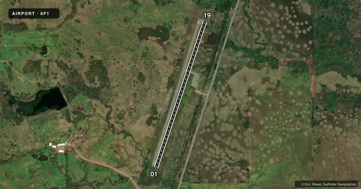
Runways & pattern
Full pagePattern entry · RWY 19
LEFT TRAFFICRunway end performance
| End | TORA | TODA | ASDA | LDA | VGSI | Approach lights | Obstruction |
|---|---|---|---|---|---|---|---|
| 01 | — | — | — | — | — | — | 9', trees, 281' from thr, 0' R of cntrln, slope 9 |
Declared distances in feet. TORA = takeoff run available, TODA = takeoff distance, ASDA = accelerate-stop, LDA = landing distance.
Airport sketch
Runways drawn to scale from FAA survey coordinates, rendered over satellite imagery. Not for navigation.
Approaches & charts
Services on the field
Fuel grades, oxygen, maintenance, ramp storage and lighting — as declared to the FAA by the airport operator.
Fuel & services
- Fuel
- Not available
Ramp & ground
- Transient storage
- Tie-down
- Landing fee
- No fee published
- Lighting schedule
- SEE RMK
- Beacon schedule
- SS-SR
- Beacon
- White / Green (civil land)(WG)
- Wind indicator
- Lighted
- Segmented circle
- Yes
Fuel & FBOs
Cheapest 100LL and Jet A on the field and nearby. Always confirm with the FBO before taxi.
Airport notes
Surface conditions, obstructions, local procedures, lighting outages and other notes published with each FAA cycle.
General notes
- FOR CD CTC FORT WORTH ARTCC AT 817-858-7584.
Lighting notes
- ACTVT MIRL RWY 01/19 - CTAF.
Approach & departure obstructions
- 019 FT TREES 120 FT FM THLD 88 FT LEFT OF CNTRLN.
- 1911FT TREES 134 FT FM THLD 315 FT LEFT OF CNTRLN.
Other notes
- ACTVT WDI LGHTS - CTAF
VFR map & nearby airports
VFR sectional. Tap any ICAO chip to open that airport.
Key facts · 6F1
Answer card- ICAO
- 6F1
- Name
- TALIHINA MUNI
- Location
- TALIHINA, OKLAHOMA
- Elevation
- 687 ft MSL
- Traffic pattern altitude
- 1,687 ft MSL (1,000 AGL)
- Control tower
- Non-towered (use CTAF)
- Total runways
- 1
- Longest runway
- 01/19 · 3,300 ft
- Published ILS approaches
- 0
- Published frequencies
- 1
- Magnetic variation
- 5°
- Current flight rules
- VFR
- Current wind
- 200° at 3 kt
- Favored runway now
- RWY 19
Talihina Muni sits in Talihina, Oklahoma. Field elevation is 687 ft MSL. The airport has one runway. Runway 01/19 is 3,300 ft long and asphalt. There is no control tower. CTAF is 122.9.
No ILS approaches are published here. Pattern altitude is not published. Use the standard 1,000 ft AGL pattern for light piston traffic unless the current Chart Supplement says otherwise. The published remarks also note that runway lights on 01/19 are activated by CTAF. The wind direction indicator lights are tied to the same frequency. That is useful after sunset when you want a quick check on field lighting.
There are no on-field FBOs listed. Plan fuel and services with the airport operator or call the field directly before departure. The published remarks also call out trees near both runway ends. On runway 01 there are 9 ft trees 120 ft from the threshold, 88 ft left of centerline. On runway 19 there are 11 ft trees 134 ft from the threshold, 315 ft left of centerline. Clearance delivery is handled through Fort Worth ARTCC at 817-858-7584. This is a non-towered field, so keep your scan tight and work the CTAF early. Check the current FAA Chart Supplement for any updated local procedures before you go.