METAR & TAF 90F
90F does not publish a METAR.
Showing the nearest reporting station: KDEQ (J LYNN HELMS SEVIER COUNTY) · 18.0 NM away. Conditions at 90F may differ.
METAR · KDEQ
Observed 15:38Z
KDEQ 241538Z AUTO 19006KT 10SM BKN018 OVC050 28/24 A3005 RMK AO2 T02780239
- Wind
- 190° @ 6 kt
- Visibility
- 10 SM
- Temp / Dew
- 28°C / 24°C
- Altimeter
- 30.05 inHg
- Clouds
- OVC
- Density alt
- 1,900 ft
- Ceiling
- 1,800 ft AGL
- Rules
- MVFR
Airport info & contacts
Manager on record, flight service, ARTCC, attendance schedule and pattern altitude — published by the FAA and refreshed every 28 days.
Location
- From city
- 2 NM SW
- VFR sectional
- MEMPHIS
- ARTCC
- ZFW · FORT WORTH
- NOTAM facility
- MLC (NOTAM-D)
Airport manager
- Name
- RANDEL RUTLEDGE
- Phone
- 580-306-2568
- Address
- CITY HALL, 210 N. BROADWAY, BROKEN BOW OK 74728
Flight service · Hours
- FSS MLC
- MC ALESTER1-800-WX-BRIEF
- Attendance
- Unattended
Frequencies
Tap any row to copy the frequency to your clipboard.
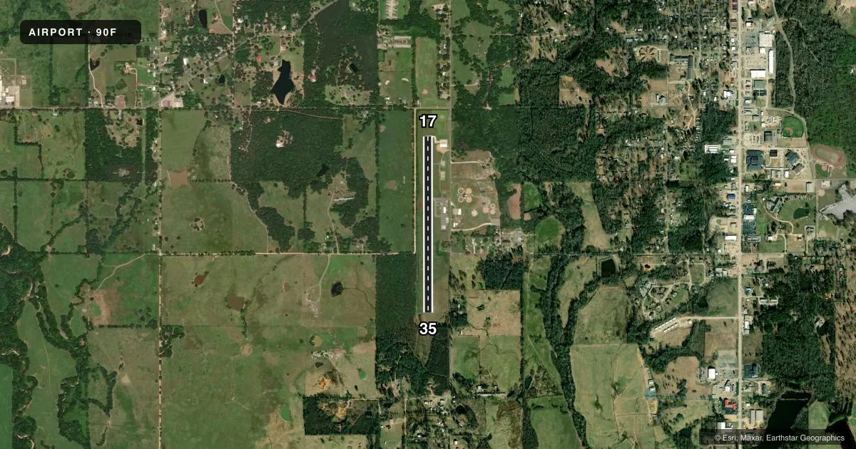
Runways & pattern
Full pagePattern entry · RWY 17
LEFT TRAFFICRunway end performance
| End | TORA | TODA | ASDA | LDA | VGSI | Approach lights | Obstruction |
|---|---|---|---|---|---|---|---|
| 17 | — | — | — | — | PAPI 2-box left(2°) | — | 55', trees, 534' from thr, 153' R of cntrln, slope 6 |
| 35 | — | — | — | — | PAPI 2-box left(2°) | — | 89', trees, 788' from thr, 271' R of cntrln, slope 6 |
Declared distances in feet. TORA = takeoff run available, TODA = takeoff distance, ASDA = accelerate-stop, LDA = landing distance.
Airport sketch
Runways drawn to scale from FAA survey coordinates, rendered over satellite imagery. Not for navigation.
Approaches & charts
Services on the field
Fuel grades, oxygen, maintenance, ramp storage and lighting — as declared to the FAA by the airport operator.
Fuel & services
- Fuel
- 100LL
- Oxygen (bottled)
- Not available
- Oxygen (bulk)
- Not available
- Airframe repair
- Not available
- Power plant repair
- Not available
Ramp & ground
- Transient storage
- Not published
- Landing fee
- No fee published
- Customs
- Not available
- Lighting schedule
- SS-SR
- Beacon schedule
- SS-SR
- Beacon
- White / Green (civil land)(WG)
- Wind indicator
- Yes
- Segmented circle
- Yes
Fuel & FBOs
Cheapest 100LL and Jet A on the field and nearby. Always confirm with the FBO before taxi.
Airport notes
Surface conditions, obstructions, local procedures, lighting outages and other notes published with each FAA cycle.
General notes
- HIGH SPEED; LOW ALTITUDE MILITARY ACTIVITY INVOF BROKEN BOW LAKE.
- FOR CD CTC FORT WORTH ARTCC AT 817-858-7584.
VFR map & nearby airports
VFR sectional. Tap any ICAO chip to open that airport.
Key facts · 90F
Answer card- ICAO
- 90F
- Name
- BROKEN BOW MUNI
- Location
- BROKEN BOW, OKLAHOMA
- Elevation
- 404 ft MSL
- Traffic pattern altitude
- 1,404 ft MSL (1,000 AGL)
- Control tower
- Non-towered (use CTAF)
- Total runways
- 1
- Longest runway
- 17/35 · 3,200 ft
- Published ILS approaches
- 0
- Published frequencies
- 1
- Magnetic variation
- 5°
- Current flight rules
- MVFR
- Current wind
- 190° at 6 kt
- Favored runway now
- RWY 17
Broken Bow Muni (90F) sits in Broken Bow, Oklahoma. Field elevation is 404 ft MSL. The airport has one runway. Runway 17/35 is 3,200 ft of asphalt. There is no control tower. CTAF is 122.9.
No ILS approaches are published here. Pattern altitude is not published, so use the standard 1,000 ft AGL for light piston operations unless the current Chart Supplement says otherwise. The airport is a simple one-runway field, so runway length is the main planning item for performance and landing distance. The published remarks also matter. High speed and low altitude military activity occurs in the vicinity of Broken Bow Lake. Keep that in mind when you are working the area near the lake. For clearance delivery, Fort Worth ARTCC can be reached at 817-858-7584.
There are no on-field FBOs listed in the facts. Contact the airport operator directly before arrival, or call the field on CTAF for current service availability. If you need current procedures, noise notes, or any local operating limits, check the current FAA Chart Supplement before you go.