METAR & TAF KDEQ
Current METAR
Observed 14:53Z
KDEQ 271453Z AUTO 26004KT 10SM CLR 29/22 A2997 RMK AO2 SLP142 T02940217 50006
- Wind
- 260° @ 4 kt
- Visibility
- 10 SM
- Temp / Dew
- 29°C / 22°C
- Altimeter
- 29.97 inHg
- Clouds
- CLR
- Density alt
- 2,058 ft
- Ceiling
- Unlimited
- Rules
- VFR
Airport info & contacts
Manager on record, flight service, ARTCC, attendance schedule and pattern altitude — published by the FAA and refreshed every 28 days.
Location
- From city
- 3 NM W
- VFR sectional
- MEMPHIS
- ARTCC
- ZFW · FORT WORTH
- NOTAM facility
- DEQ (NOTAM-D)
Airport manager
- Name
- SCOTT SIMMONS
- Phone
- 870-582-2492
- Address
- PO BOX 206, DEQUEEN AR 71832
Flight service · Hours
- FSS JBR
- JONESBORO1-800-WX-BRIEF
- Attendance
- Unattended
Frequencies
Tap any row to copy the frequency to your clipboard.
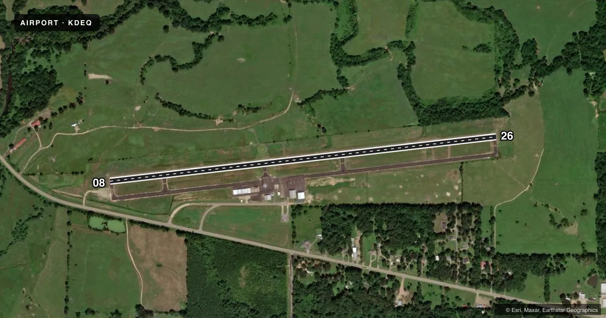
Runways & pattern
Full pagePattern entry · RWY 26
LEFT TRAFFICRunway end performance
| End | TORA | TODA | ASDA | LDA | VGSI | Approach lights | Obstruction |
|---|---|---|---|---|---|---|---|
| 08 | — | — | — | — | PAPI 2-box left(3°) | — | 25', tree, 1075' from thr, 10' R of cntrln, slope 35 |
| 26 | — | — | — | — | PAPI 2-box left(3°) | — | 45', trees, 1500' from thr, 400' R of cntrln, slope 28 |
Declared distances in feet. TORA = takeoff run available, TODA = takeoff distance, ASDA = accelerate-stop, LDA = landing distance.
Airport sketch
Runways drawn to scale from FAA survey coordinates, rendered over satellite imagery. Not for navigation.
Approaches & charts
Services on the field
Fuel grades, oxygen, maintenance, ramp storage and lighting — as declared to the FAA by the airport operator.
Fuel & services
- Fuel
- 100LLA
- Airframe repair
- Not available
- Power plant repair
- Not available
- Other services
- AGRI
Ramp & ground
- Transient storage
- Tie-down
- Hangar
- Landing fee
- No fee published
- Customs
- Not available
- Lighting schedule
- SEE RMK
- Beacon schedule
- SS-SR
- Beacon
- White / Green (civil land)(WG)
- Wind indicator
- Lighted
- Segmented circle
- Yes
Fuel & FBOs
Cheapest 100LL and Jet A on the field and nearby. Always confirm with the FBO before taxi.
Airport notes
Surface conditions, obstructions, local procedures, lighting outages and other notes published with each FAA cycle.
General notes
- (E81) TWY EXIT SIGNS.
- FOR CD CTC FORT WORTH ARTCC AT 817-858-7584.
Lighting notes
- DUSK-DAWN. ACTVT REIL RWY 08 & 26; PAPI RWY 08 & 26; MIRL RWY 08/26 - CTAF.
Fuel notes
- 100LLFUEL AVBL 24 HR SELF SERVE WITH MAJOR CC (100LL & JET A)
Approach & departure obstructions
- 26+6 FT FENCE 198 FT FM RY END 100 FT L.
Other notes
- THIS AIRPORT HAS BEEN SURVEYED BY THE NATIONAL GEODETIC SURVEY.
- MANAGERSECONDARY PHONE #: 870-582-5414
VFR map & nearby airports
VFR sectional. Tap any ICAO chip to open that airport.
Key facts · KDEQ
Answer card- ICAO
- KDEQ
- Name
- J LYNN HELMS SEVIER COUNTY
- Location
- DE QUEEN, ARKANSAS
- Elevation
- 354.8 ft MSL
- Traffic pattern altitude
- 1,354.8 ft MSL (1,000 AGL)
- Control tower
- Non-towered (use CTAF)
- Total runways
- 1
- Longest runway
- 08/26 · 5,001 ft
- Published ILS approaches
- 0
- Published frequencies
- 2
- Magnetic variation
- 4°
- Current flight rules
- VFR
- Current wind
- 260° at 4 kt
- Favored runway now
- RWY 26
J Lynn Helms Sevier County Airport sits in De Queen, Arkansas. Field elevation is 354.8 ft MSL. The airport has one runway. Runway 08/26 is 5,001 ft long with asphalt pavement. The field is not towered. CTAF and UNICOM are both 122.8. No ILS approaches are published here.
Pattern altitude is not published. Use 1,000 ft AGL as the standard light-piston pattern reference unless local procedures or the current Chart Supplement say otherwise. The airport has a single on-field FBO, Sevier County Airport. It carries 100LL and Jet A Prist. Fuel is available 24 hours self-serve with major credit cards. The published remarks also note runway end identifier lights, PAPI on both runway ends and medium intensity runway lights that are controlled on the CTAF.
For a first trip in, pay attention to the runway 26 fence note. There is a 6-foot fence 198 feet from the runway end and 100 feet left of centerline. Taxiway exit signs are installed. For clearance delivery, contact Fort Worth ARTCC. If you need current operating details, check the current FAA Chart Supplement or call the airport operator directly.