METAR & TAF M77
M77 does not publish a METAR.
Showing the nearest reporting station: KDEQ (J LYNN HELMS SEVIER COUNTY) · 28.1 NM away. Conditions at M77 may differ.
METAR · KDEQ
Observed 14:53Z
KDEQ 271453Z AUTO 26004KT 10SM CLR 29/22 A2997 RMK AO2 SLP142 T02940217 50006
- Wind
- 260° @ 4 kt
- Visibility
- 10 SM
- Temp / Dew
- 29°C / 22°C
- Altimeter
- 29.97 inHg
- Clouds
- CLR
- Density alt
- 2,304 ft
- Ceiling
- Unlimited
- Rules
- VFR
Airport info & contacts
Manager on record, flight service, ARTCC, attendance schedule and pattern altitude — published by the FAA and refreshed every 28 days.
Location
- From city
- 3 NM N
- VFR sectional
- MEMPHIS
- ARTCC
- ZFW · FORT WORTH
- NOTAM facility
- JBR (NOTAM-D)
Airport manager
- Name
- MARK WILEY
- Phone
- 870-904-0733
- Address
- 421 N MAIN, NASHVILLE AR 71852
Flight service · Hours
- FSS JBR
- JONESBORO1-800-WX-BRIEF
- Attendance
- Unattended
Frequencies
Tap any row to copy the frequency to your clipboard.
Runways & pattern
Full pagePattern entry · RWY 19
LEFT TRAFFICRunway end performance
| End | TORA | TODA | ASDA | LDA | VGSI | Approach lights | Obstruction |
|---|---|---|---|---|---|---|---|
| 01 | — | — | — | — | PAPI 2-box left(3°) | — | 40', trees, 1650' from thr, 525' R of cntrln, slope 36 |
| 19 | — | — | — | — | PAPI 2-box left(3°) | — | 15', trees, 500' from thr, 95' R of cntrln, slope 20 |
Declared distances in feet. TORA = takeoff run available, TODA = takeoff distance, ASDA = accelerate-stop, LDA = landing distance.
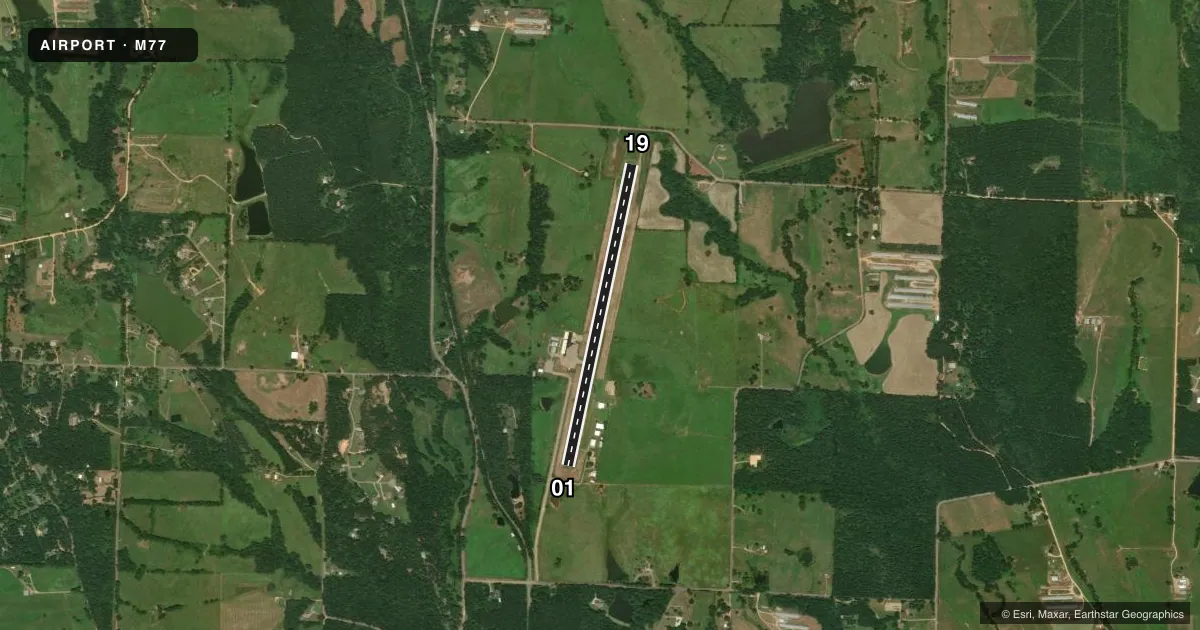
Airport sketch
Runways drawn to scale from FAA survey coordinates, rendered over satellite imagery. Not for navigation.
Approaches & charts
Services on the field
Fuel grades, oxygen, maintenance, ramp storage and lighting — as declared to the FAA by the airport operator.
Fuel & services
- Fuel
- 100LL
- Oxygen (bottled)
- Not available
- Oxygen (bulk)
- Not available
- Airframe repair
- Not available
- Power plant repair
- Not available
Ramp & ground
- Transient storage
- Tie-down
- Landing fee
- No fee published
- Customs
- Not available
- Lighting schedule
- SEE RMK
- Beacon schedule
- SS-SR
- Beacon
- White / Green (civil land)(WG)
- Wind indicator
- Lighted
- Segmented circle
- No
Fuel & FBOs
Cheapest 100LL and Jet A on the field and nearby. Always confirm with the FBO before taxi.
Airport notes
Surface conditions, obstructions, local procedures, lighting outages and other notes published with each FAA cycle.
General notes
- RY 01 FENCE 3 FT AND ROAD 7 FT BELOW THLD 200 FT FM RY END.
- RY 19 TURNAROUND HAS A 10 FT DROP OFF.
- FOR CD CTC FORT WORTH ARTCC AT 817-858-7584.
Lighting notes
- ACTVT MIRL RWY 01/19 & PAPI RWYS 01 & 19 - CTAF.
Fuel notes
- 100LLSELF SERVE FUEL AVBL 24 HRS.
Approach & departure obstructions
- 01+3 FT FENCE 183 FT FROM RWY END.
- 01MARKINGS FADED RWY 1
- 19MARKINGS FADED RWY 19
- 01APCH RATIO 44:1 FM DTHR.
VFR map & nearby airports
VFR sectional. Tap any ICAO chip to open that airport.
Key facts · M77
Answer card- ICAO
- M77
- Name
- HOWARD COUNTY
- Location
- NASHVILLE, ARKANSAS
- Elevation
- 553.1 ft MSL
- Traffic pattern altitude
- 1,553.1 ft MSL (1,000 AGL)
- Control tower
- Non-towered (use CTAF)
- Total runways
- 1
- Longest runway
- 01/19 · 3,994 ft
- Published ILS approaches
- 0
- Published frequencies
- 1
- Magnetic variation
- 2°
- Current flight rules
- VFR
- Current wind
- 260° at 4 kt
- Favored runway now
- RWY 19
Howard County Airport sits in Nashville, Arkansas. Field elevation is 553.1 ft MSL. The airport has one runway. Runway 01/19 is 3,994 ft long with an asphalt surface. There is no control tower. CTAF is 122.9. No ILS approaches are published here.
Pattern altitude is not published. Use 1,000 ft AGL for light piston traffic unless the current Chart Supplement says otherwise. That puts the pattern at about 1,553 ft MSL based on the field elevation. The runway lights and PAPI on both ends are activated on CTAF. Self-serve 100LL is available 24 hours.
For a first-time arrival, pay attention to the runway end notes. Markings are faded on both runway ends. Runway 01 has nearby fence and road obstacles near the threshold. Runway 19 has a turnaround with a 10-foot drop off. The approach to runway 01 also has a published 44:1 ratio from the displaced threshold. There is no on-field FBO listed, so plan fuel and ground support with the airport operator or call ahead before you go. For clearance delivery, Fort Worth ARTCC is listed in the remarks. Check current procedures before departure.