METAR & TAF M18
M18 does not publish a METAR.
Showing the nearest reporting station: KTXK (TEXARKANA RGNL-WEBB FLD) · 23.1 NM away. Conditions at M18 may differ.
METAR · KTXK
Observed 04:53Z
KTXK 270453Z AUTO 20005KT 10SM CLR 30/23 A2995 RMK AO2 SLP137 T03000228
- Wind
- 200° @ 5 kt
- Visibility
- 10 SM
- Temp / Dew
- 30°C / 23°C
- Altimeter
- 29.95 inHg
- Clouds
- CLR
- Density alt
- 2,208 ft
- Ceiling
- Unlimited
- Rules
- VFR
Airport info & contacts
Manager on record, flight service, ARTCC, attendance schedule and pattern altitude — published by the FAA and refreshed every 28 days.
Location
- From city
- 4 NM NW
- VFR sectional
- MEMPHIS
- ARTCC
- ZFW · FORT WORTH
- NOTAM facility
- JBR (NOTAM-D)
Airport manager
- Name
- DARRELL ALLEN
- Phone
- 870-777-3444
- Address
- PO BOX 667, HOPE AR 71802
Flight service · Hours
- FSS JBR
- JONESBORO1-800-WX-BRIEF
- Attendance
- MON-THU · 0600-1630
Frequencies
Tap any row to copy the frequency to your clipboard.
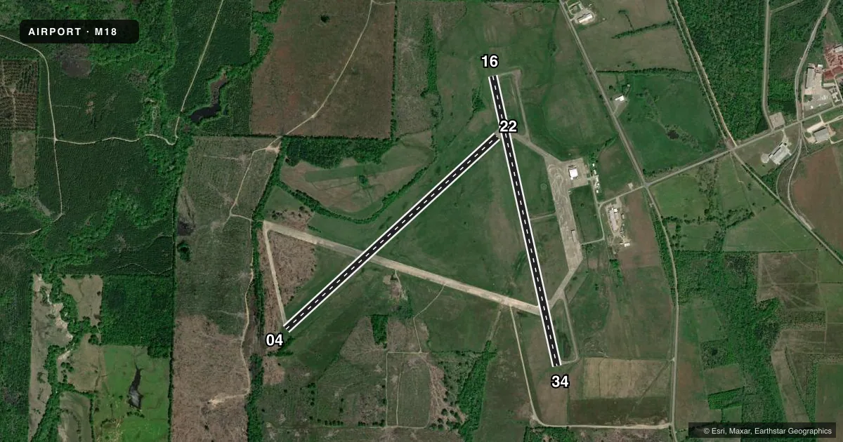
Runways & pattern
Full pagePattern entry · RWY 22
LEFT TRAFFIC| Runway | Heading (°M) | Length | Surface | Traffic |
|---|---|---|---|---|
| 16/34 | 164° / 344° | 5,501 ft | CONC | Standard L |
| 04/22Favored | 45° / 225° | 5,301 ft | CONC | Standard L |
Runway end performance
| End | TORA | TODA | ASDA | LDA | VGSI | Approach lights | Obstruction |
|---|---|---|---|---|---|---|---|
| 16 | — | — | — | — | PAPI 2-box left(3°) | — | 32', tree, 1300' from thr, 330' R of cntrln, slope 34 |
| 34 | — | — | — | — | PAPI 2-box left(3°) | — | 29', trees, 1200' from thr, 0' R of cntrln, slope 34 |
| 04 | — | — | — | — | — | — | 50', trees, 250' from thr, 0' R of cntrln, slope 1 |
Declared distances in feet. TORA = takeoff run available, TODA = takeoff distance, ASDA = accelerate-stop, LDA = landing distance.
Airport sketch
Runways drawn to scale from FAA survey coordinates, rendered over satellite imagery. Not for navigation.
Approaches & charts
Services on the field
Fuel grades, oxygen, maintenance, ramp storage and lighting — as declared to the FAA by the airport operator.
Fuel & services
- Fuel
- 100LLA
- Airframe repair
- Not available
- Power plant repair
- Not available
Ramp & ground
- Transient storage
- Tie-down
- Hangar
- Landing fee
- No fee published
- Customs
- Not available
- Lighting schedule
- SEE RMK
- Beacon schedule
- SS-SR
- Beacon
- White / Green (civil land)(WG)
- Wind indicator
- Lighted
- Segmented circle
- Yes
Fuel & FBOs
Cheapest 100LL and Jet A on the field and nearby. Always confirm with the FBO before taxi.
Airport notes
Surface conditions, obstructions, local procedures, lighting outages and other notes published with each FAA cycle.
General notes
- FOR CD CTC FORT WORTH ARTCC AT 817-858-7584.
- DEER ON & INVOF ARPT.
Lighting notes
- DUSK-DAWN. REIL & MIRL RY 16/34 OPER DUSK-2200; AFT 2200 ACTVT - CTAF.
Fuel notes
- 100LLSELF-SERVE FUEL AVBL 24 HRS (100LL & JET A)
Runway surface & condition
- 16/34NSTD MIRL - LGTS LCTD APRXLY 35 FT FM MARKED RY EDGE.
Approach & departure obstructions
- 04CNTRLN AND THR MKGS FADED.
- 16CNTRLN AND THR MKGS FADED.
- 22CNTRLN AND THR MKGS FADED.
- 34CNTRLN AND THR MKGS FADED.
- 04APCH RATIO FROM DSPLCD THR 28:1.
Other notes
- EXISTED PRIOR TO 1959.
- 1FOR SVC AFT HRS CALL 870-397-1651
VFR map & nearby airports
VFR sectional. Tap any ICAO chip to open that airport.
Key facts · M18
Answer card- ICAO
- M18
- Name
- HOPE MUNI
- Location
- HOPE, ARKANSAS
- Elevation
- 359.2 ft MSL
- Traffic pattern altitude
- 1,359.2 ft MSL (1,000 AGL)
- Control tower
- Non-towered (use CTAF)
- Total runways
- 2
- Longest runway
- 16/34 · 5,501 ft
- Published ILS approaches
- 0
- Published frequencies
- 2
- Magnetic variation
- 3°
- Current flight rules
- VFR
- Current wind
- 200° at 5 kt
- Favored runway now
- RWY 22
Hope Muni sits in Hope, Arkansas at 359.2 ft MSL. It has two concrete runways. The longest is 16/34 at 5,501 ft. Runway 04/22 is 5,301 ft. The field is non-towered. CTAF and UNICOM are both 122.8. No ILS approaches are published here.
Pattern altitude is not published. Use the standard 1,000 ft AGL for light piston operations unless the current FAA Chart Supplement says otherwise. The airport has one on-field FBO, Hope Municipal Airport. It carries AVGAS 100LL and Jet A with Prist. Self-serve fuel is available 24 hours for both grades.
A few field notes matter here. Runway 04 has faded centerline and threshold markings. Runway 16/34 also has faded centerline and threshold markings. The runway 16/34 lighting is nonstandard, with the medium intensity lights set about 35 ft from the marked edge. Lighting runs from dusk to dawn. The runway end identifier lights and the runway 16/34 medium intensity lights operate from dusk to 2200. After 2200, lighting is activated on CTAF. Deer are reported on and near the airport. For clearance delivery, contact Fort Worth ARTCC. For after-hours service, call the airport number in the Chart Supplement or the FBO directly by phone.