METAR & TAF 4F8
4F8 does not publish a METAR.
Showing the nearest reporting station: KAGO (RALPH C WEISER FLD) · 15.3 NM away. Conditions at 4F8 may differ.
METAR · KAGO
Observed 15:15Z
KAGO 271515Z AUTO VRB06KT 10SM CLR 32/24 A2998 RMK A01
- Wind
- VAR @ 6 kt
- Visibility
- 10 SM
- Temp / Dew
- 32°C / 24°C
- Altimeter
- 29.98 inHg
- Clouds
- CLR
- Density alt
- 2,251 ft
- Ceiling
- Unlimited
- Rules
- VFR
Airport info & contacts
Manager on record, flight service, ARTCC, attendance schedule and pattern altitude — published by the FAA and refreshed every 28 days.
Location
- From city
- 2 NM NE
- VFR sectional
- MEMPHIS
- ARTCC
- ZFW · FORT WORTH
- NOTAM facility
- JBR (NOTAM-D)
Airport manager
- Name
- RICHARD WILLIAMSON
- Phone
- 870-510-5874
- Address
- PO BOX 85, STAMPS AR 71860
Flight service · Hours
- FSS JBR
- JONESBORO1-800-WX-BRIEF
- Attendance
- Unattended
Frequencies
Tap any row to copy the frequency to your clipboard.
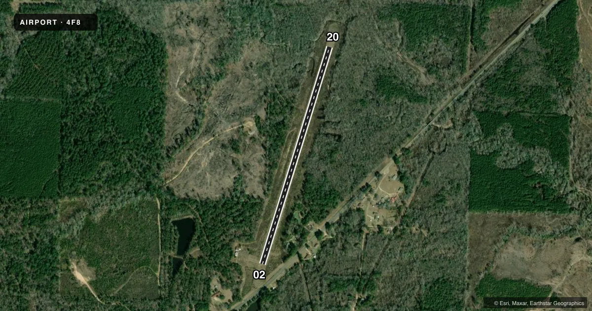
Runways & pattern
Full pagePattern entry · RWY 02
LEFT TRAFFICRunway end performance
| End | TORA | TODA | ASDA | LDA | VGSI | Approach lights | Obstruction |
|---|---|---|---|---|---|---|---|
| 02 | — | — | — | — | — | — | 60', trees, 450' from thr, 150' R of cntrln, slope 4 |
| 20 | — | — | — | — | — | — | 60', trees, 375' from thr, 90' R of cntrln, slope 2 |
Declared distances in feet. TORA = takeoff run available, TODA = takeoff distance, ASDA = accelerate-stop, LDA = landing distance.
Airport sketch
Runways drawn to scale from FAA survey coordinates, rendered over satellite imagery. Not for navigation.
Approaches & charts
Services on the field
Fuel grades, oxygen, maintenance, ramp storage and lighting — as declared to the FAA by the airport operator.
Fuel & services
- Fuel
- Not available
- Oxygen (bottled)
- Not available
- Oxygen (bulk)
- Not available
- Airframe repair
- Not available
- Power plant repair
- Not available
Ramp & ground
- Transient storage
- Tie-down
- Landing fee
- No fee published
- Customs
- Not available
- Beacon schedule
- SS-SR
- Beacon
- White / Green (civil land)(WG)
- Wind indicator
- No
- Segmented circle
- Yes
Fuel & FBOs
Cheapest 100LL and Jet A on the field and nearby. Always confirm with the FBO before taxi.
Airport notes
Surface conditions, obstructions, local procedures, lighting outages and other notes published with each FAA cycle.
General notes
- DEER ON & INVOF ARPT.
- FOR CD CTC FORT WORTH ARTCC AT 817-858-7584.
Lighting notes
- BCN OTS INDEFLY
Runway surface & condition
- 02/20RWY LIGHTS OTS INDEFLY
Approach & departure obstructions
- 02MARKINGS FADED
- 20MARKINGS FADED
Other notes
- 02/20RWY 02-20 MANY LONGITUDINAL CRACKS WITH VEGETATION.
VFR map & nearby airports
VFR sectional. Tap any ICAO chip to open that airport.
Key facts · 4F8
Answer card- ICAO
- 4F8
- Name
- WILSON
- Location
- STEPHENS, ARKANSAS
- Elevation
- 230 ft MSL
- Traffic pattern altitude
- 1,230 ft MSL (1,000 AGL)
- Control tower
- Non-towered (use CTAF)
- Total runways
- 1
- Longest runway
- 02/20 · 3,000 ft
- Published ILS approaches
- 0
- Published frequencies
- 1
- Magnetic variation
- 4°
- Current flight rules
- VFR
- Current wind
- 000° at 6 kt
- Favored runway now
- RWY 02
Wilson Airport (4F8) sits in Stephens, Arkansas. Field elevation is 230 ft MSL. The airport has one runway. Runway 02/20 is 3,000 ft long with an asphalt surface. There is no control tower. CTAF is 122.9. No ILS approaches are published here.
Pattern altitude is not published. Use the standard 1,000 ft AGL for light piston traffic unless the current Chart Supplement says otherwise. That puts the pattern at 1,230 ft MSL based on the field elevation. Verify before you fly. Published remarks matter here. Runway lights are out of service indefinitely. The airport beacon is also out of service indefinitely. Runway 02/20 has longitudinal cracks with vegetation. Markings on both ends are faded. Runway 20 is specifically noted as faded. Deer are on and in the vicinity of the airport.
For clearance delivery, Fort Worth ARTCC is listed in the remarks. If you need current operational details, check the current FAA Chart Supplement or contact the airport operator directly. This is a small non-towered field. Plan your arrival with the runway condition, wildlife and lighting status in mind.