METAR & TAF 0R6
0R6 does not publish a METAR.
Showing the nearest reporting station: KCDH (HARRELL FLD) · 16.3 NM away. Conditions at 0R6 may differ.
METAR · KCDH
Observed 18:35Z
KCDH 261835Z AUTO 28007KT 9SM FEW280 SCT330 SCT360 SCT380 35/23 A2998 RMK AO2 T03480230 $
- Wind
- 280° @ 7 kt
- Visibility
- 9 SM
- Temp / Dew
- 35°C / 23°C
- Altimeter
- 29.98 inHg
- Clouds
- SCT
- Density alt
- 2,546 ft
- Ceiling
- Unlimited
- Rules
- VFR
Airport info & contacts
Manager on record, flight service, ARTCC, attendance schedule and pattern altitude — published by the FAA and refreshed every 28 days.
Location
- From city
- 2 NM SE
- VFR sectional
- MEMPHIS
- ARTCC
- ZME · MEMPHIS
- NOTAM facility
- JBR (NOTAM-D)
Airport manager
- Name
- FLOYD W. NUTT / RICK SHIRRON
- Phone
- 870-798-4818
- Address
- PO BOX 566, HAMPTON AR 71744
Flight service · Hours
- FSS JBR
- JONESBORO1-800-WX-BRIEF
- Attendance
- Unattended
Frequencies
Tap any row to copy the frequency to your clipboard.
Runways & pattern
Full pagePattern entry · RWY 20
LEFT TRAFFICRunway end performance
| End | TORA | TODA | ASDA | LDA | VGSI | Approach lights | Obstruction |
|---|---|---|---|---|---|---|---|
| 02 | — | — | — | — | — | — | 25', trees, 200' from thr, 0' R of cntrln, slope 0 |
| 20 | — | — | — | — | — | — | 75', trees, 950' from thr, 100' R of cntrln, slope 10 |
Declared distances in feet. TORA = takeoff run available, TODA = takeoff distance, ASDA = accelerate-stop, LDA = landing distance.
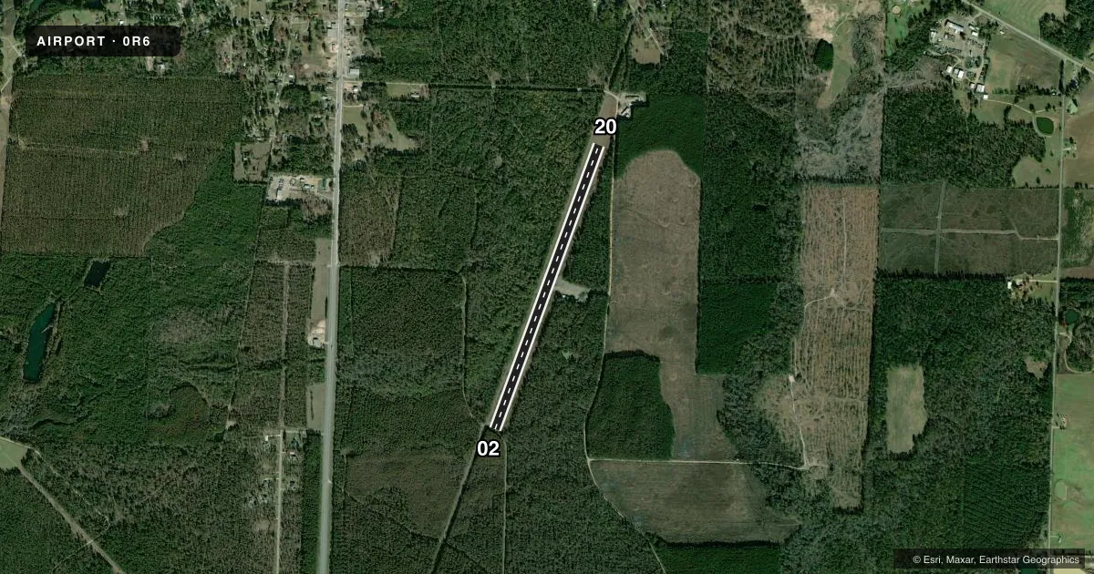
Airport sketch
Runways drawn to scale from FAA survey coordinates, rendered over satellite imagery. Not for navigation.
Approaches & charts
Services on the field
Fuel grades, oxygen, maintenance, ramp storage and lighting — as declared to the FAA by the airport operator.
Fuel & services
- Fuel
- Not available
Ramp & ground
- Transient storage
- Not published
- Landing fee
- No fee published
- Wind indicator
- Yes
- Segmented circle
- No
Fuel & FBOs
Cheapest 100LL and Jet A on the field and nearby. Always confirm with the FBO before taxi.
Airport notes
Surface conditions, obstructions, local procedures, lighting outages and other notes published with each FAA cycle.
General notes
- DEER ON & INVOF ARPT
- FOR CD CTC MEMPHIS ARTCC AT 901-368-8453/8449.
Approach & departure obstructions
- 02+20 FT TREE 10 FT SOUTH; +15 FT ROAD 30 FT SOUTH.
- 02MARKINGS FADED.
- 20MARKINGS FADED.
Other notes
- VFR OPNS ONLY.
- MANAGERCOUNTY JUDGE / MAYOR
- 02/20POTHOLES NORTHERN THIRD OF RWY.
VFR map & nearby airports
VFR sectional. Tap any ICAO chip to open that airport.
Key facts · 0R6
Answer card- ICAO
- 0R6
- Name
- HAMPTON MUNI
- Location
- HAMPTON, ARKANSAS
- Elevation
- 178 ft MSL
- Traffic pattern altitude
- 1,178 ft MSL (1,000 AGL)
- Control tower
- Non-towered (use CTAF)
- Total runways
- 1
- Longest runway
- 02/20 · 4,326 ft
- Published ILS approaches
- 0
- Published frequencies
- 1
- Magnetic variation
- 4°
- Current flight rules
- VFR
- Current wind
- 280° at 7 kt
- Favored runway now
- RWY 20
Hampton Muni sits in Hampton, Arkansas. Field elevation is 178 ft MSL. The airport has one runway. Runway 02/20 is 4,326 ft of asphalt. There is no control tower, so use CTAF 122.9 and standard non-towered procedures. No ILS approaches are published here. Pattern altitude is not published in the Chart Supplement. Plan on the standard 1,000 ft AGL for light piston traffic unless the current FAA Chart Supplement says otherwise.
This is a VFR-only field per the published remarks. That matters for planning. Deer are reported on and near the airport. There is also a 20-foot tree 10 feet south of the runway 02 end. A 15-foot road sits 30 feet south of that end. Runway 02 markings are faded. Runway 20 markings are faded too. The northern third of the runway has potholes, so a careful taxi and landing rollout check makes sense on arrival and departure.
No on-field FBOs are listed. Contact the airport operator directly before arrival if you need local services. For clearance delivery, the published remarks point pilots to Memphis ARTCC by phone. First-time visitors should treat this as a small rural strip with basic facilities, VFR-only operations and a runway that deserves a close look before you commit.