METAR & TAF 3M9
3M9 does not publish a METAR.
Showing the nearest reporting station: KLLQ (MONTICELLO MUNI/ELLIS FLD) · 17.4 NM away. Conditions at 3M9 may differ.
METAR · KLLQ
Observed 11:53Z
KLLQ 271153Z AUTO 00000KT 10SM CLR 26/22 A2997 RMK AO2 SLP145 T02610222 10289 20256 53013
- Wind
- 000° @ 0 kt
- Visibility
- 10 SM
- Temp / Dew
- 26°C / 22°C
- Altimeter
- 29.97 inHg
- Clouds
- CLR
- Density alt
- 1,549 ft
- Ceiling
- Unlimited
- Rules
- VFR
Airport info & contacts
Manager on record, flight service, ARTCC, attendance schedule and pattern altitude — published by the FAA and refreshed every 28 days.
Location
- From city
- 3 NM S
- VFR sectional
- MEMPHIS
- ARTCC
- ZME · MEMPHIS
- NOTAM facility
- JBR (NOTAM-D)
Airport manager
- Name
- DR. JOE WHARTON
- Phone
- 870-820-9119
- Address
- 10 SYLVAN HILLS DR., WARREN AR 71671
Flight service · Hours
- FSS JBR
- JONESBORO1-800-WX-BRIEF
- Attendance
- Unattended
Frequencies
Tap any row to copy the frequency to your clipboard.
Runways & pattern
Full pagePattern entry · RWY 03
LEFT TRAFFICRunway end performance
| End | TORA | TODA | ASDA | LDA | VGSI | Approach lights | Obstruction |
|---|---|---|---|---|---|---|---|
| 03 | — | — | — | — | PAPI 2-box left(3°) | — | 30', trees, 1200' from thr, 0' R of cntrln, slope 33 |
| 21 | — | — | — | — | PAPI 2-box left(3.5°) | — | 10', road, 201' from thr, 170' R of cntrln, slope 0 |
Declared distances in feet. TORA = takeoff run available, TODA = takeoff distance, ASDA = accelerate-stop, LDA = landing distance.
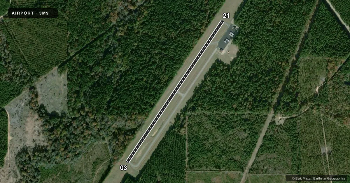
Airport sketch
Runways drawn to scale from FAA survey coordinates, rendered over satellite imagery. Not for navigation.
Approaches & charts
Services on the field
Fuel grades, oxygen, maintenance, ramp storage and lighting — as declared to the FAA by the airport operator.
Fuel & services
- Fuel
- 100LL
- Oxygen (bottled)
- Not available
- Oxygen (bulk)
- Not available
- Airframe repair
- Not available
- Power plant repair
- Not available
Ramp & ground
- Transient storage
- Tie-down
- Landing fee
- No fee published
- Customs
- Not available
- Lighting schedule
- SEE RMK
- Beacon schedule
- SS-SR
- Beacon
- White / Green (civil land)(WG)
- Wind indicator
- Lighted
- Segmented circle
- No
Fuel & FBOs
Cheapest 100LL and Jet A on the field and nearby. Always confirm with the FBO before taxi.
Airport notes
Surface conditions, obstructions, local procedures, lighting outages and other notes published with each FAA cycle.
General notes
- DEER ON & INVOF ARPT. CTC POLICE 870-226-3703 TO CLEAR RWY.
Lighting notes
- ACTVT LIRL & PAPI RWY 03/21 - CTAF
Fuel notes
- 100LLSELF SVC FUEL AVBL 24 HRS WITH CREDIT CARD.
Approach & departure obstructions
- 03PAPI UNUSBL BYD 2 DEGS LEFT OF CNTRLN.
- 21PAPI UNUSBL BYD 3 DEGS RIGHT AND LEFT OF CNTRLN.
Other notes
- THIS AIRPORT HAS BEEN SURVEYED BY THE NATIONAL GEODETIC SURVEY.
- 1FOR SERVICES CALL 870-226-6743 OR AFT HRS 870-226-3703.
- MANAGERCOMMISSION CHAIRMAN.
VFR map & nearby airports
VFR sectional. Tap any ICAO chip to open that airport.
Key facts · 3M9
Answer card- ICAO
- 3M9
- Name
- WARREN MUNI/JOHN B FRAZER JR FLD
- Location
- WARREN, ARKANSAS
- Elevation
- 235 ft MSL
- Traffic pattern altitude
- 1,235 ft MSL (1,000 AGL)
- Control tower
- Non-towered (use CTAF)
- Total runways
- 1
- Longest runway
- 03/21 · 3,829 ft
- Published ILS approaches
- 0
- Published frequencies
- 1
- Magnetic variation
- 0°
- Current flight rules
- VFR
- Current wind
- 000° at 0 kt
- Favored runway now
- –
Warren Muni/John B Frazer Jr Fld sits in Warren, Arkansas. The field elevation is 235 ft MSL. It has one asphalt runway, 03/21, at 3,829 ft. There is no control tower. CTAF is 122.9.
No ILS approaches are published here. Pattern altitude is not published, so use the standard 1,000 ft AGL unless the current Chart Supplement says otherwise. The airport uses low intensity runway lights and PAPI on runway 03/21. The lights and PAPI are activated by the CTAF.
Warren Municipal Airport is the on-field FBO. It carries 100LL. Self-serve 100LL is available 24 hours with a credit card. For services, call the airport at the number in the Chart Supplement. Deer are reported on and near the airport, so plan a careful taxi and runway scan, especially at dawn and dusk. The PAPI has published viewing limits on both ends, so verify glidepath cues on short final and do not rely on it outside the usable centerline range. The airport is surveyed by the National Geodetic Survey.