METAR & TAF 55M
55M does not publish a METAR.
Showing the nearest reporting station: KPBF (PINEBLUFF RGNL/GRIDER FLD) · 15.3 NM away. Conditions at 55M may differ.
METAR · KPBF
Observed 15:53Z
KPBF 271553Z AUTO 25005KT 10SM CLR 34/22 A2996 RMK AO2 SLP140 T03390222 PWINO
- Wind
- 250° @ 5 kt
- Visibility
- 10 SM
- Temp / Dew
- 34°C / 22°C
- Altimeter
- 29.96 inHg
- Clouds
- CLR
- Density alt
- 2,724 ft
- Ceiling
- Unlimited
- Rules
- VFR
Airport info & contacts
Manager on record, flight service, ARTCC, attendance schedule and pattern altitude — published by the FAA and refreshed every 28 days.
Location
- From city
- 2 NM SW
- VFR sectional
- MEMPHIS
- ARTCC
- ZME · MEMPHIS
- NOTAM facility
- JBR (NOTAM-D)
Airport manager
- Name
- MATTHEW PADGETT
- Phone
- 870-329-0484
- Address
- PO BOX 219, STAR CITY AR 71667
Flight service · Hours
- FSS JBR
- JONESBORO1-800-WX-BRIEF
- Attendance
- Unattended
Frequencies
Tap any row to copy the frequency to your clipboard.
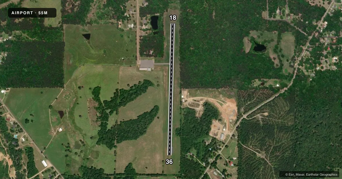
Runways & pattern
Full pagePattern entry · RWY 18
LEFT TRAFFICRunway end performance
| End | TORA | TODA | ASDA | LDA | VGSI | Approach lights | Obstruction |
|---|---|---|---|---|---|---|---|
| 18 | — | — | — | — | — | — | 30', tree, 300' from thr, 130' R of cntrln, slope 3 |
| 36 | — | — | — | — | — | — | 50', tree, 450' from thr, 140' R of cntrln, slope 5 |
Declared distances in feet. TORA = takeoff run available, TODA = takeoff distance, ASDA = accelerate-stop, LDA = landing distance.
Airport sketch
Runways drawn to scale from FAA survey coordinates, rendered over satellite imagery. Not for navigation.
Approaches & charts
Services on the field
Fuel grades, oxygen, maintenance, ramp storage and lighting — as declared to the FAA by the airport operator.
Fuel & services
- Fuel
- 100LL
- Oxygen (bottled)
- Not available
- Oxygen (bulk)
- Not available
Ramp & ground
- Transient storage
- Tie-down
- Landing fee
- No fee published
- Lighting schedule
- SS-SR
- Wind indicator
- Yes
- Segmented circle
- No
Fuel & FBOs
Cheapest 100LL and Jet A on the field and nearby. Always confirm with the FBO before taxi.
Airport notes
Surface conditions, obstructions, local procedures, lighting outages and other notes published with each FAA cycle.
General notes
- FOR CD CTC MEMPHIS ARTCC AT 901-368-8453/8449.
Fuel notes
- 100LLSELF SERVE FUEL AVBL 24 HRS WITH CREDIT CARD.
Approach & departure obstructions
- 18RWY 18 MARKINGS FADED
- 36RWY 36 MARKINGS FADED
Other notes
- MANAGERPAD_7507@YAHOO.COM
VFR map & nearby airports
VFR sectional. Tap any ICAO chip to open that airport.
Key facts · 55M
Answer card- ICAO
- 55M
- Name
- JB WEST MUNICIPAL AIRPORT
- Location
- STAR CITY, ARKANSAS
- Elevation
- 398 ft MSL
- Traffic pattern altitude
- 1,398 ft MSL (1,000 AGL)
- Control tower
- Non-towered (use CTAF)
- Total runways
- 1
- Longest runway
- 18/36 · 3,000 ft
- Published ILS approaches
- 0
- Published frequencies
- 1
- Magnetic variation
- 4°
- Current flight rules
- VFR
- Current wind
- 250° at 5 kt
- Favored runway now
- RWY 18
JB West Municipal Airport sits in Star City, Arkansas. The field elevation is 398 ft MSL. It has one runway. The longest runway is 18/36 at 3,000 ft of asphalt. The airport is not towered. CTAF is 122.9.
No ILS approaches are published here. The pattern altitude is not published, so use the standard 1,000 ft AGL for light piston traffic unless the current FAA Chart Supplement says otherwise. With the field at 398 ft MSL, that works out to about 1,398 ft MSL. Runway 18 and runway 36 markings are reported as faded, so plan for a careful look on short final and on rollout.
Star City Municipal Airport is on the field and carries AVGAS 100LL. Self-serve fuel is available 24 hours with credit card. For clearance delivery, contact Memphis ARTCC before departure if you need IFR coordination. The airport sits in flat Arkansas terrain, so the main pilot concern is straightforward local traffic and runway identification rather than terrain. Check the current FAA Chart Supplement for any published noise or curfew restrictions before flying into the field.