METAR & TAF 7M1
7M1 does not publish a METAR.
Showing the nearest reporting station: KLLQ (MONTICELLO MUNI/ELLIS FLD) · 19.3 NM away. Conditions at 7M1 may differ.
METAR · KLLQ
Observed 15:53Z
KLLQ 271553Z AUTO 26008KT 10SM CLR 34/21 A2996 RMK AO2 SLP141 T03440211
- Wind
- 260° @ 8 kt
- Visibility
- 10 SM
- Temp / Dew
- 34°C / 21°C
- Altimeter
- 29.96 inHg
- Clouds
- CLR
- Density alt
- 2,405 ft
- Ceiling
- Unlimited
- Rules
- VFR
Airport info & contacts
Manager on record, flight service, ARTCC, attendance schedule and pattern altitude — published by the FAA and refreshed every 28 days.
Location
- From city
- 2 NM E
- VFR sectional
- MEMPHIS
- ARTCC
- ZME · MEMPHIS
- NOTAM facility
- JBR (NOTAM-D)
Airport manager
- Name
- BILL SIMMONS
- Phone
- 870-919-5172
- Address
- P.O. BOX 612, MC GEHEE AR 71654
Flight service · Hours
- FSS JBR
- JONESBORO1-800-WX-BRIEF
- Attendance
- FEB - OCT · MON-FRI · 0800-1700
Frequencies
Tap any row to copy the frequency to your clipboard.
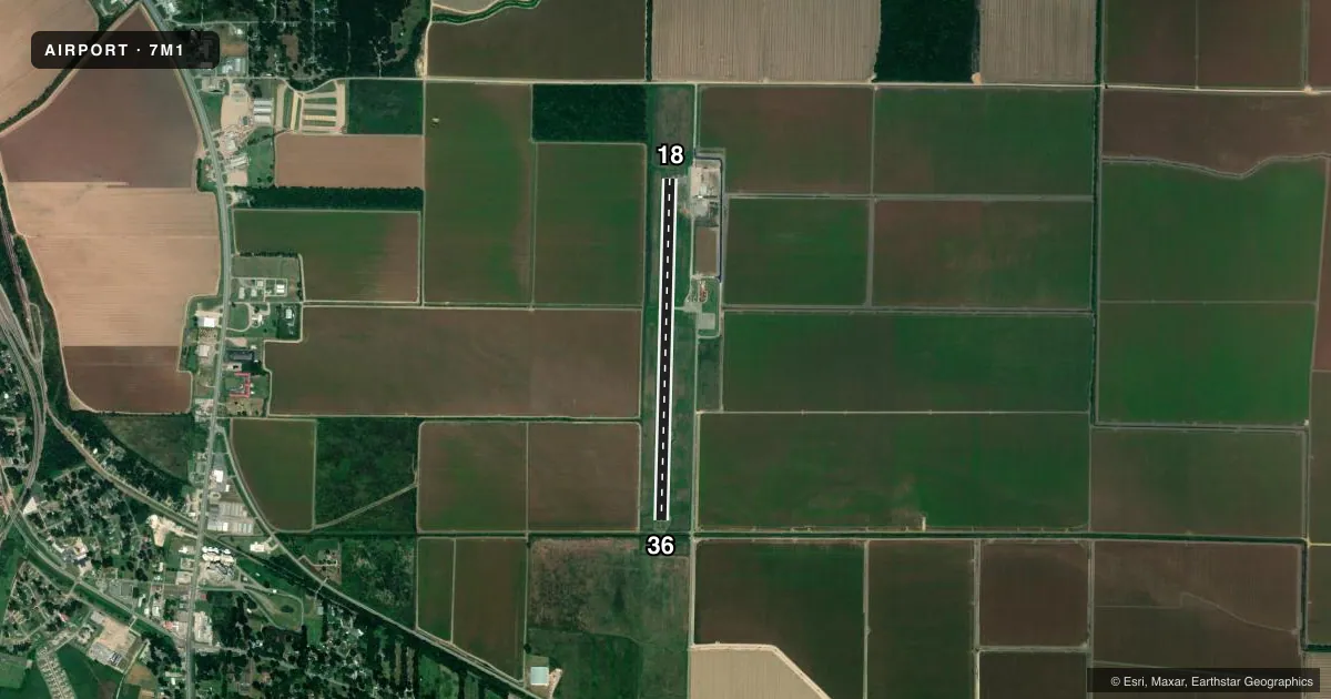
Runways & pattern
Full pagePattern entry · RWY 18
LEFT TRAFFICAirport sketch
Runways drawn to scale from FAA survey coordinates, rendered over satellite imagery. Not for navigation.
Approaches & charts
Services on the field
Fuel grades, oxygen, maintenance, ramp storage and lighting — as declared to the FAA by the airport operator.
Fuel & services
- Fuel
- 100LLA
- Oxygen (bottled)
- Not available
- Oxygen (bulk)
- Not available
- Other services
- AGRI
Ramp & ground
- Transient storage
- Tie-down
- Landing fee
- No fee published
- Customs
- Not available
- Lighting schedule
- SS-SR
- Beacon schedule
- SS-SR
- Beacon
- White / Green (civil land)(WG)
- Wind indicator
- Yes
- Segmented circle
- Yes
Fuel & FBOs
Cheapest 100LL and Jet A on the field and nearby. Always confirm with the FBO before taxi.
Airport notes
Surface conditions, obstructions, local procedures, lighting outages and other notes published with each FAA cycle.
General notes
- RY 36 TURNAROUND HAS 3-4 FT DROP-OFF ON EAST & NORTH SIDE.
- NUMEROUS AGRICULTURE ACFT OPS FROM FEB-NOV 500 FT AGL AND BELOW.
- FOR CD CTC MEMPHIS ARTCC AT 901-368-8453/8449.
Fuel notes
- 100LL24 HR SELF SERVICE FUEL AVBL WITH CREDIT CARD.
Approach & departure obstructions
- 18DITCH 100 FT B0TH SIDES OF EXTDD CNTRLN APRXLY 3 FT DEEP.
- 36EROSION FM END OF CULVERT TOWARD CNTR, BOTH SIDES 6 FT LONG 1-3 FT DEEP.
Other notes
- LAND PURCHASED
- THIS AIRPORT HAS BEEN SURVEYED BY THE NATIONAL GEODETIC SURVEY.
- 1FOR SRVC AFT HRS CALL 870-644-0069 OR 870-222-8830
VFR map & nearby airports
VFR sectional. Tap any ICAO chip to open that airport.
Key facts · 7M1
Answer card- ICAO
- 7M1
- Name
- MC GEHEE MUNI
- Location
- MC GEHEE, ARKANSAS
- Elevation
- 141 ft MSL
- Traffic pattern altitude
- 1,141 ft MSL (1,000 AGL)
- Control tower
- Non-towered (use CTAF)
- Total runways
- 1
- Longest runway
- 18/36 · 4,007 ft
- Published ILS approaches
- 0
- Published frequencies
- 1
- Magnetic variation
- 1°
- Current flight rules
- VFR
- Current wind
- 260° at 8 kt
- Favored runway now
- RWY 18
Mc Gehee Muni is in Mc Gehee, Arkansas. The field elevation is 141 ft MSL. It has one runway, 18/36, which is 4,007 ft long. There is no control tower. No ILS approaches are published. The pattern altitude is not published, so use the standard 1,000 ft AGL for light piston traffic unless current local guidance says otherwise.
This is a simple single-runway airport, but there are a few things to brief before you go. Runway 36 has a turnaround with a 3 to 4 ft drop-off on the east and north side. Runway 18 has a ditch about 100 ft both sides of the extended centerline. It is about 3 ft deep. Runway 36 also has erosion near the end of the culvert toward center on both sides. The airport has 24-hour self-serve 100LL with credit card. For after-hours service, call the numbers listed in the Chart Supplement.
There are no on-field FBOs listed. CTAF is 122.9. Clearance delivery is handled through Memphis ARTCC using the published phone numbers. Expect ag operations from February through November at 500 ft AGL and below. That matters for low-level traffic and pattern awareness. If you need current noise, curfew, or airport-use details, check the current FAA Chart Supplement or call the airport operator before departure.