METAR & TAF KRNV
Current METAR
Observed 16:35Z
KRNV 271635Z AUTO 00000KT 9SM CLR 34/25 A2994 RMK AO2 T03410248 $
- Wind
- 000° @ 0 kt
- Visibility
- 9 SM
- Temp / Dew
- 34°C / 25°C
- Altimeter
- 29.94 inHg
- Clouds
- CLR
- Density alt
- 2,429 ft
- Ceiling
- Unlimited
- Rules
- VFR
Airport info & contacts
Manager on record, flight service, ARTCC, attendance schedule and pattern altitude — published by the FAA and refreshed every 28 days.
Location
- From city
- 2 NM NW
- VFR sectional
- MEMPHIS
- ARTCC
- ZME · MEMPHIS
- NOTAM facility
- GWO (NOTAM-D)
Airport manager
- Name
- CLINT JOHNSON
- Phone
- 662-719-1189
- Address
- PO BOX 1439, CLEVELAND MS 38732
Flight service · Hours
- FSS GWO
- GREENWOOD1-800-WX-BRIEF
- Attendance
- MON-FRI · 0800-1700
- SAT-SUN · ON CALL
Frequencies
Tap any row to copy the frequency to your clipboard.
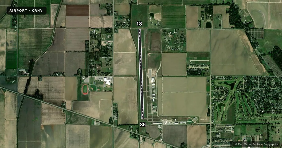
Runways & pattern
Full pagePattern entry · RWY 18
LEFT TRAFFICRunway end performance
| End | TORA | TODA | ASDA | LDA | VGSI | Approach lights | Obstruction |
|---|---|---|---|---|---|---|---|
| 18 | — | — | — | — | PAPI 4-box left(3°) | — | — |
| 36 | — | — | — | — | PAPI 4-box right(3.25°) | — | 40', trees, 1000' from thr, 0' R of cntrln, slope 20 |
Declared distances in feet. TORA = takeoff run available, TODA = takeoff distance, ASDA = accelerate-stop, LDA = landing distance.
Airport sketch
Runways drawn to scale from FAA survey coordinates, rendered over satellite imagery. Not for navigation.
Approaches & charts
Services on the field
Fuel grades, oxygen, maintenance, ramp storage and lighting — as declared to the FAA by the airport operator.
Fuel & services
- Fuel
- 100LLA
- Oxygen (bottled)
- Not available
- Oxygen (bulk)
- Not available
- Airframe repair
- Major
- Power plant repair
- Major
- Other services
- AGRI,INSTR,RNTL
Ramp & ground
- Transient storage
- Tie-down
- Landing fee
- No fee published
- Customs
- Not available
- Lighting schedule
- SEE RMK
- Beacon schedule
- SS-SR
- Beacon
- White / Green (civil land)(WG)
- Wind indicator
- Lighted
- Segmented circle
- Yes
Fuel & FBOs
Cheapest 100LL and Jet A on the field and nearby. Always confirm with the FBO before taxi.
Airport notes
Surface conditions, obstructions, local procedures, lighting outages and other notes published with each FAA cycle.
General notes
- STUDENT ACT ON & INVOF ARPT.
- FOR CD CTC MEMPHIS ARTCC AT 901-368-8453/8449.
- COURTESY CAR AVBL.
Lighting notes
- ACTVT REIL RWY 18 & 36; MIRL RWY 18/36 - CTAF. PAPI RWY 18 & 36 OPR CONSLY.
Fuel notes
- 100LLFUEL AVBL WITH CREDIT CARD 24 HRS.
Other notes
- EXISTED PRIOR TO 1959.
- PILOTS MUST PRVD THEIR OWN TIEDOWN ROPES.
VFR map & nearby airports
VFR sectional. Tap any ICAO chip to open that airport.
Key facts · KRNV
Answer card- ICAO
- KRNV
- Name
- CLEVELAND MUNI
- Location
- CLEVELAND, MISSISSIPPI
- Elevation
- 140 ft MSL
- Traffic pattern altitude
- 1,140 ft MSL (1,000 AGL)
- Control tower
- Non-towered (use CTAF)
- Total runways
- 1
- Longest runway
- 18/36 · 5,005 ft
- Published ILS approaches
- 0
- Published frequencies
- 2
- Magnetic variation
- 0°
- Current flight rules
- VFR
- Current wind
- 000° at 0 kt
- Favored runway now
- –
Cleveland Muni sits in Cleveland, Mississippi. The field elevation is 140 ft MSL. It has one runway, 18/36, which is 5,005 ft long and asphalt. The airport is non-towered. CTAF and UNICOM are both 122.725. No ILS approaches are published here.
Pattern altitude is not published. Use the standard 1,000 ft AGL for light piston traffic unless the current Chart Supplement says otherwise. The runway lighting is pilot-controlled on CTAF. Runway end identifier lights are available for both ends. Precision approach path indicators operate continuously for runway 18 and runway 36.
Air Repair is on field. It carries AVGAS 100LL and Jet A. Fuel is available 24 hours with a credit card. Pilots should bring their own tiedown ropes. Student activity is noted on and near the airport, so expect training traffic. For clearance delivery, contact Memphis ARTCC at the numbers listed in the Chart Supplement. If you need current operating details before arrival, confirm with the airport operator or the FBO directly by phone.