METAR & TAF M37
M37 does not publish a METAR.
Showing the nearest reporting station: KRNV (CLEVELAND MUNI) · 11.7 NM away. Conditions at M37 may differ.
METAR · KRNV
Observed 16:15Z
KRNV 261615Z AUTO 26005KT 10SM CLR 32/28 A3001 RMK AO2 T03150279 $
- Wind
- 260° @ 5 kt
- Visibility
- 10 SM
- Temp / Dew
- 32°C / 28°C
- Altimeter
- 30.01 inHg
- Clouds
- CLR
- Density alt
- 2,098 ft
- Ceiling
- Unlimited
- Rules
- VFR
Airport info & contacts
Manager on record, flight service, ARTCC, attendance schedule and pattern altitude — published by the FAA and refreshed every 28 days.
Location
- From city
- 2 NM S
- VFR sectional
- MEMPHIS
- ARTCC
- ZME · MEMPHIS
- NOTAM facility
- GWO (NOTAM-D)
Airport manager
- Name
- BUDDY WEEKS
- Phone
- 662-745-2733
- Address
- 4141 HWY 49 W, DREW MS 38737
Flight service · Hours
- FSS GWO
- GREENWOOD1-800-WX-BRIEF
- Attendance
- IREG
Frequencies
Tap any row to copy the frequency to your clipboard.
Runways & pattern
Full pagePattern entry · RWY 18
LEFT TRAFFICRunway end performance
| End | TORA | TODA | ASDA | LDA | VGSI | Approach lights | Obstruction |
|---|---|---|---|---|---|---|---|
| 18 | — | — | — | — | PAPI 2-box left(3°) | — | — |
| 36 | — | — | — | — | PAPI 2-box left(3°) | — | — |
Declared distances in feet. TORA = takeoff run available, TODA = takeoff distance, ASDA = accelerate-stop, LDA = landing distance.
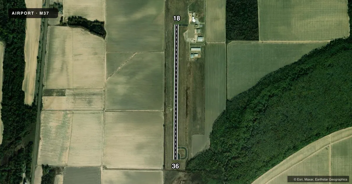
Airport sketch
Runways drawn to scale from FAA survey coordinates, rendered over satellite imagery. Not for navigation.
Approaches & charts
Services on the field
Fuel grades, oxygen, maintenance, ramp storage and lighting — as declared to the FAA by the airport operator.
Fuel & services
- Fuel
- Not available
- Oxygen (bottled)
- Not available
- Oxygen (bulk)
- Not available
- Airframe repair
- Not available
- Power plant repair
- Not available
- Other services
- AGRI
Ramp & ground
- Transient storage
- Tie-down
- Landing fee
- No fee published
- Customs
- Not available
- Lighting schedule
- SEE RMK
- Beacon schedule
- SS-SR
- Beacon
- White / Green (civil land)(WG)
- Wind indicator
- Lighted
- Segmented circle
- Yes
Fuel & FBOs
Cheapest 100LL and Jet A on the field and nearby. Always confirm with the FBO before taxi.
Airport notes
Surface conditions, obstructions, local procedures, lighting outages and other notes published with each FAA cycle.
General notes
- FOR CD CTC MEMPHIS ARTCC AT 901-368-8453/8449.
Lighting notes
- OTS INDEF.
- MIRL RWY 18/36 OPRS DUSK-2200; AFT 2200 ACTVT - CTAF. PAPI RWY 18 & 36 OPR CONSLY.
Other notes
- THIS AIRPORT HAS BEEN SURVEYED BY THE NATIONAL GEODETIC SURVEY.
- PILOTS MUST PRVD THEIR OWN TIEDOWN ROPES.
- MANAGERMELANIE TOWNSEND-BLACKMAN, MAYOR OF DREW 662-745-8556.
VFR map & nearby airports
VFR sectional. Tap any ICAO chip to open that airport.
Key facts · M37
Answer card- ICAO
- M37
- Name
- RULEVILLE-DREW
- Location
- DREW, MISSISSIPPI
- Elevation
- 137 ft MSL
- Traffic pattern altitude
- 1,137 ft MSL (1,000 AGL)
- Control tower
- Non-towered (use CTAF)
- Total runways
- 1
- Longest runway
- 18/36 · 3,000 ft
- Published ILS approaches
- 0
- Published frequencies
- 1
- Magnetic variation
- 0°
- Current flight rules
- VFR
- Current wind
- 260° at 5 kt
- Favored runway now
- RWY 18
Ruleville-Drew Airport sits in Drew, Mississippi. Field elevation is 137 ft MSL. The airport has one runway, 18/36, at 3,000 ft of asphalt. There is no control tower. CTAF is 122.9. No ILS approaches are published here, so plan with the current chart and your own weather minimums.
Pattern altitude is not published. Use 1,000 ft AGL for light piston operations unless the current Chart Supplement says otherwise. The runway lights on 18/36 operate from dusk to 2200. After 2200, they are activated by CTAF. The PAPI on both ends operates continuously. The beacon and lens are out of service indefinitely, so do not rely on them for night orientation. Pilots must bring their own tiedown ropes.
There are no on-field FBOs listed in the facts. Contact the airport operator directly before arrival if you need fuel or ramp details. For clearance delivery, Memphis ARTCC is the published contact. First-time arrivals should also note that this field has been surveyed by the National Geodetic Survey. Keep an eye on the runway lighting setup if you plan a late arrival. Verify any current operational details in the FAA Chart Supplement before you go.