METAR & TAF KCKM
Current METAR
Observed 14:55Z
KCKM 161455Z AUTO RMK A01 PNO
- Wind
- Calm
- Visibility
- —
- Temp / Dew
- —
- Altimeter
- —
- Clouds
- Clear
- Density alt
- —
- Ceiling
- Unlimited
- Rules
- VFR
Airport info & contacts
Manager on record, flight service, ARTCC, attendance schedule and pattern altitude — published by the FAA and refreshed every 28 days.
Location
- From city
- 7 NM NE
- VFR sectional
- MEMPHIS
- ARTCC
- ZME · MEMPHIS
- NOTAM facility
- GWO (NOTAM-D)
Airport manager
- Name
- DAVID HUGGINS
- Phone
- 662-627-4126
- Address
- PO BOX 700, CLARKSDALE MS 38614
Flight service · Hours
- FSS GWO
- GREENWOOD1-800-WX-BRIEF
- Attendance
- DALGT
Frequencies
Tap any row to copy the frequency to your clipboard.
Runways & pattern
Full pagePattern entry · RWY 18
LEFT TRAFFICRunway end performance
| End | TORA | TODA | ASDA | LDA | VGSI | Approach lights | Obstruction |
|---|---|---|---|---|---|---|---|
| 18 | — | — | — | — | PAPI 4-box right(3°) | — | — |
| 36 | — | — | — | — | PAPI 4-box left(3°) | — | 95', trees, 2240' from thr, 200' R of cntrln, slope 21 |
Declared distances in feet. TORA = takeoff run available, TODA = takeoff distance, ASDA = accelerate-stop, LDA = landing distance.
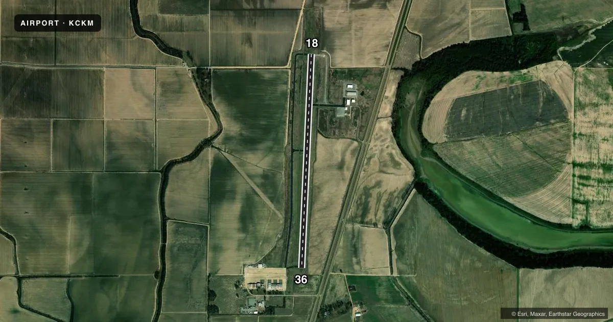
Airport sketch
Runways drawn to scale from FAA survey coordinates, rendered over satellite imagery. Not for navigation.
Approaches & charts
Services on the field
Fuel grades, oxygen, maintenance, ramp storage and lighting — as declared to the FAA by the airport operator.
Fuel & services
- Fuel
- 100LLA
- Oxygen (bottled)
- Not available
- Oxygen (bulk)
- Not available
- Power plant repair
- Minor
- Other services
- AGRI,INSTR,RNTL
Ramp & ground
- Transient storage
- Tie-down
- Hangar
- Landing fee
- No fee published
- Customs
- Not available
- Lighting schedule
- SEE RMK
- Beacon schedule
- SS-SR
- Beacon
- White / Green (civil land)(WG)
- Wind indicator
- Lighted
- Segmented circle
- Yes
Fuel & FBOs
Cheapest 100LL and Jet A on the field and nearby. Always confirm with the FBO before taxi.
Airport notes
Surface conditions, obstructions, local procedures, lighting outages and other notes published with each FAA cycle.
General notes
- NMRS AGRICULTURAL ACFT OPS W OF N/S TWY. ACFT DEP N & LAND S.
- TWY LGTS ON S STUB TWY TO APN.
- FOR CD CTC MEMPHIS ARTCC AT 901-368-8453/8449.
Lighting notes
- ACTVT REIL RWY 18 & 36; MIRL RWY 18/36 - CTAF. PAPI RWY 18 & 36 OPR CONSLY.
Fuel notes
- 100LLFUEL AVBL 24 HRS WITH CREDIT CARD. OTS INDEF.
Runway surface & condition
- 18/361 HR PPR FOR ACFT OVER 30000 LBS, CALL 662-624-5554 OR 662-902-1893.
Other notes
- EXISTED PRIOR TO 1959.
- PILOTS MUST PRVD THEIR OWN TIEDOWN ROPES.
- OWNERAND CITY OF CLARKSDALE.
VFR map & nearby airports
VFR sectional. Tap any ICAO chip to open that airport.
Key facts · KCKM
Answer card- ICAO
- KCKM
- Name
- FLETCHER FLD
- Location
- CLARKSDALE, MISSISSIPPI
- Elevation
- 173.3 ft MSL
- Traffic pattern altitude
- 1,173.3 ft MSL (1,000 AGL)
- Control tower
- Non-towered (use CTAF)
- Total runways
- 1
- Longest runway
- 18/36 · 5,404 ft
- Published ILS approaches
- 0
- Published frequencies
- 2
- Magnetic variation
- 0°
- Current flight rules
- VFR
- Current wind
- Calm / unavailable
- Favored runway now
- –
Fletcher Fld sits in Clarksdale, Mississippi. The field elevation is 173.3 ft MSL. It has one runway, 18/36, at 5,404 ft. There is no control tower. Pattern altitude is not published, so use the standard 1,000 ft AGL for light piston operations unless the current Chart Supplement says otherwise.
No ILS approaches are published here. CTAF and UNICOM are both 122.8. Red Panther Aero is on the field. It carries 100LL and Jet A. Fuel is available 24 hours with credit card. The airport also notes that pilots must provide their own tiedown ropes.
A few local items matter for planning. Agricultural aircraft operate west of the north-south taxiway. Aircraft depart to the north and land to the south. Taxiway lights are on the south stub taxiway to the apron. Runway end identifier lights on 18 and 36 operate by CTAF. The medium intensity runway lights on 18/36 also activate by CTAF. PAPI on both ends runs continuously. The airport is owned by the City of Clarksdale. For clearance delivery, contact Memphis ARTCC before departure if you need it.